


ALONG THE RIO COLORADO — They came to see the river return, a half-century after U.S. dams kept it from flowing into Mexico.
Forty-seven-year-old Carlos Bazua drove 30 miles from his home in Mexicali, Baja California.
“Since I was a kid, my father told me that long ago there was water, but I do not remember that,” he said.
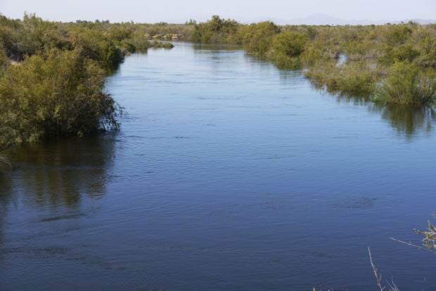
He stood Thursday next to the San Luis Bridge over the river that links Baja California with Sonora. The Colorado now carried enough water for kids to stand in waist-deep. “I feel great,” Bazua said.
“I hope so, I hope so,” he said, when asked if he thought the U.S. and Mexico can continue the progress they made in agreeing to let the water return.
“Water is life. It brings life to everyone. It’s better for wildlife,” he said.
On hand at the bridge was Jennifer Pitt, director of the Environmental Defense Fund’s Colorado River Project, and one of the key players in the complex negotiations that made this historic release of water possible.
She had been at the bridge on Tuesday and seen only a dry channel, but people were already standing there, drinking sodas and beer, waiting.
That night, after the first water arrived, “there was a party — music, fireworks and cervezas.”
Once a desert oasis
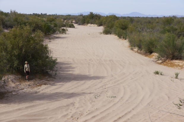
One minute, the river was sand and salt cedar, nothing more. The next minute, water dribbled into view from the north, making a faint, bubbling sound as it oozed a path a few feet wide through a channel at least five times as wide and 20 feet deep.
“This is the Colorado River,” said Dale Turner, a conservation planner for the Nature Conservancy, smiling as he watched.
The spot where the water arrived at 3:40 on Friday — in Baja California, about five miles downstream from the San Luis Bridge — was not the river delta that at least two generations of Sonora and Baja California residents have known for most of the past 50 years.
Except during periodic floods — nonexistent for the last 15 of those years — that river was a dry, dusty vehicle for non-native shrubbery to thrive in, but not much else.
The river’s water is shared between seven U.S. states and Mexico to serve cities and farms, and until now, no one would agree to give up some to replenish the delta, once a lush desert oasis.
But the new binational agreement allows release of 105,000 acre-feet — enough to serve 200,000 to 300,000 people annually — through the river’s plumbing system of dams and canals going as far north as Lake Mead at the Arizona-Nevada border.
The water’s last stop in that system, Morelos Dam at the U.S.-Mexican border, started releasing the water into the delta in small quantities a week ago today and stepped up the releases on Thursday. The peak releases end this weekend and releases will continue in much lesser amounts until May 8.
The spot the water reached Friday afternoon lies 30 to 35 twisting and turning river miles downstream from the dam. How far and how intensively it will travel and how much good it will do this now-sapped delta remains a matter of informed speculation.
The Nature Conservancy, other environmental groups and a phalanx of U.S. and Mexican researchers were on hand last week and will return off and on over the next few months and years to record what happens.
Their hope is that the results of what they call a pilot project, to last five years, will lay the groundwork for future agreements to continue the releases. That’s also an unknown, given the strong potential for future droughts and river shortages due to climate change.
But for the conservancy’s Turner and Brooke Gebow, who photographed “before” and “after” shots of the river from a week ago and now this day, it was a time to celebrate.
They saw a side-blotched lizard — “our first refugee,” said Gebow — perched halfway up a dead branch above the river and a caterpillar slither through neighboring rocks to avoid the water. They saw the stream channel gradually get broader and deeper. As more water arrived, the stream’s bubbling grew more audible.
“Yippie,” said Gebow, the conservancy’s Southeastern Arizona preserve manager. “This is a big day.”
Echoed Turner, of the group’s Tucson office, “Rivers look good with water in them.”
Side channels
Just east of the river and about 40 miles south of Morelos Dam, a group of activists who have worked to restore the river’s once-ubiquitous cottonwood and willow trees are eagerly awaiting the new water.
They work at the four-mile-long Laguna Grande site, where now stands the largest grove of cottonwoods and willows in the entire river delta that runs from just south of Yuma for at least 70 miles into the Gulf of California.
The site is run jointly by the Tucson-based Sonoran Institute and ProNatura Noroeste, a Mexican conservation group. They say that this site contains more cottonwoods today than the total living in the rest of the delta.
The trees here — 80,000 so far — stand up to 45 feet tall, and in stark contrast to the sand that adjoins them.
The entire area was “absolute sand” before the first batch of trees was planted two years ago, observed Peter Culp, an attorney who represented conservation interests in the multiparty negotiations that led to the water release.
The trees occupy 95 acres. The groups hope to plant as many as 400 acres this year and eventually, 1,200 acres total here and at a second site in the Baja town of Miguel Alleman, lying upstream. Their goal is to restore four to five other sites along the river over the next decade or two.
The group is hoping the restoration efforts will eventually re-create meandering side channels to connect with the main river channel, said Francisco Zamora, director of the institute’s delta legacy program.
Water for the trees has come so far through an irrigation canal, which carries river water for which conservation groups have purchased water rights from Mexican farmers. They now have more than 7,500 acre-feet annually of such rights and hope to have 10,000 by the end of the five-year test period. They hope that the new release of water will germinate more trees and raise the water table enough to keep them alive long after the major pulse flow is gone.
“This seems like a magical moment, silently, a river coming down here,” said Yamilett Carrillo, director of ProNatura’s Sustainable Water Initiative for northwest Mexico, who lives in San Luis Rio Colorado, Sonora. “A lot of kids were out there at the river when the water arrived this week,” she noted.
“I’ve been hearing all kinds of stories from people — you ask them what the river meant for you and they say that the river is life. . . My kids are so young, they thought the river was a canal.”
Karina Patino took a moment from planting trees for ProNatura to say that while she was growing up in San Luis, her grandparents and parents were always talking about how great the river was, with its water and trees and wildlife.
“It was very hard imagining that scenario,” Patino said through a translator. “I was always seeing the river dry, with different vegetation than what they described.”
“We’ve waited 50 years”
What she saw was mostly salt cedar, also known as tamarisks, shrubs that thrive in dry weather and can compete with cottonwoods and willows even when it’s wet.
On Friday, as the Nature Conservancy’s Turner and Gebow drove up and down the river in both countries to shoot pictures, many of the salt cedars were partially submerged. In some areas in Mexico where the river hadn’t reached, the salt cedars still stood tall. At one spot just below where Turner and Gebow rejoiced at the site of river water, however, the river carried nothing but sand.
At one U.S. spot about four miles below Morelos Dam, a U.S. Geological Survey monitoring station was recording a speed of 3,350 cubic feet per second. The river normally carries water at this spot but a month ago it was running at about 20 cfs, said Jimmy Tunnell, a USGS hydraulic technician.
In fact, just the day before, he was able to step on a concrete footing to his left and now it’s submerged, Tunnell said. In various spots, the river there ranges from 20 to 35 feet deep, he said.
Along the river delta from Morelos Dam well into Mexico, 22 such monitoring sites are being run by the USGS and other parties to record the water table’s elevation and how well cottonwood and willow seedlings respond to the new water.
In addition, the Baja California-based UABC university has temperature sensors planted along the river as a way to measure river flow — the temperature drops suddenly when the water arrives.
By late Friday, the newly released water still was flowing through the upper part of a very sandy area, an area where some hydrologists were concerned that the water might all seep into the groundwater rather than move downstream. But most experts associated with the water release were still optimistic that the river would continue flowing well south of that point to nourish trees down below.
“I think we’re on target,” said Karl Flessa, a University of Arizona Geosciences professor, and co-director of the delta restoration monitoring effort.
“Most people are really anxious for water to move faster. Water is going to move at the rate it’s going to move," said Flessa, a former UA Geosciences Department head. "In a sense, we’ve waited 50 years for this to happen.”

