


Arizona can be divided into three physiographic zones, each distinct and unique from the other. They are: the Colorado Plateau, the Arizona Transition Zone and the Basin and Range Province.
The Colorado Plateau in Northern Arizona is the largest portion, covering 42 percent of the state. The Transition Zone in Central Arizona includes 28 percent of the state. The Basin and Range Province in the south encompasses 30 percent of the state.
Ninety percent of Arizona’s population is found in the Basin and Range Province, which includes the large metropolitan areas of Phoenix and Tucson. Parts of the Colorado Plateau and the Basin and Range Province are found in northwestern Arizona.
Basin and Range topography covers northern Mexico along with Arizona, California, Nevada, Utah and part of Idaho. Its parallel mountain ranges, many composed of igneous rock trending north-south or northwest-southeast separated by broad valleys, are one of its key characteristics, along with low elevation, lack of surface water and dryness.
Dryness is brought about by the rain shadow effect caused by California mountain ranges including the Sierra Nevadas, whose western flanks draw upon the majority of moisture from the Pacific, leaving only scattered remnants reaching Arizona except during times of tropical depression. Some mountain ranges differ in pattern. Those include the Buckskin Mountains, Harcuvar Mountains, Harquahala Mountains and White Tank Mountains that trend northeast-southwest.
The Basin and Range geologic province encompasses several desert regions in Arizona including the Mohave, Sonoran (120,000 square miles) and Chihuahuan deserts covering the western and southern parts of the state. The Basin and Range geologic provinces are characterized by being separated by broad sandy basins, between steep, linear mountain ranges. Some of these ranges include the “Sky Islands,” which are more than 9,000 feet above sea level and include the Chiricahua, Huachuca, Santa Catalina and Santa Rita Mountains.
The mountain sky islands are biologically diverse, with many unique plant and animal species endemic to their geographic boundaries.
Additional mountains include the Hualapai and Phoenix mountains in northwestern Arizona. The Pinaleño Mountain range includes Mount Graham, which at 10,717 feet is the highest peak in Southeastern Arizona.
The Phoenix and Hualapai Mountains around Kingman are part of the northwestern topographic band of Basin and Range in Arizona. Major waterways found in the Basin and Range include the Little Colorado, Santa Cruz, San Pedro and San Simon rivers, all of which flow northward.
Instigated by the effect of tectonic plate movements along North America’s west coast over the past 15 to 30 million years, the Basin and Range Province has been undergoing crustal extension, a pull-apart action of the earth’s crust responsible for geologic uplift and faulting.
Mountain-building episodes known as orogenies caused by the rise and fall of crustal blocks along with volcanism were responsible for forming the topography that today defines Arizona’s Basin and Range Province.
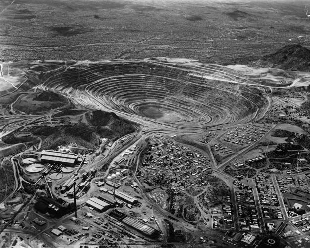
Chief mineral commodities of the Basin and Range Province include copper, silver, gold and industrial minerals.
The Basin and Range geologic province includes the bulk of the porphyry copper deposits in Arizona. Porphyry is a term defining an igneous rock with a homogeneous ground-mass that encloses distinct crystals including quartz, feldspar and hornblende. It is used in relation to large low-grade copper deposits and sometimes referred to as “disseminated.”
A good analogy of porphyritic rock is raisins in a muffin. The raisins are the ore deposits that lie buried in the muffin, or waste rock.
The novel concept of recovering these metal-bearing ores was implemented by Daniel Jackling, at Bingham Canyon, Utah, in 1907. Jackling, a metallurgical engineer, pioneered the method of open-pit mining as a means of developing and processing the ore body on a large industrial scale. Chief mineral commodities of the Basin and Range Province include copper, lead and molybdenum.

