Where does water go when it rains? The answer: It depends. Exactly how rainfall gets partitioned among evaporation, infiltration into soils and aquifers and discharge into streams depends on the unique features of the climate and landscape where it falls.
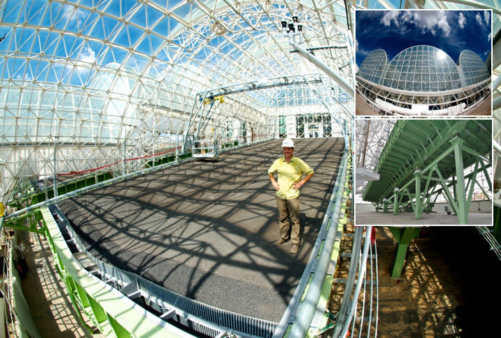
We are using a groundbreaking, new experimental infrastructure to better understand how landscapes store and transmit water, called the Landscape Evolution Observatory.
LEO includes three artificial landscapes constructed inside the University of Arizona’s Biosphere 2 north of Tucson in Oracle. Each landscape consists of more than 1 million pounds of loamy sand soil packed to a depth of 3.3 feet within a supporting structure. Each landscape surface covers more than 3,500 square feet and has a 10 degree slope. The downslope portion converges into a gully, creating similar topography as exists in upland landscapes in the southwestern United States. The landscapes have a bare-soil surface, though in years to come they will be colonized by microorganisms and plants.
Although we can directly measure the amount of water available in a river channel or aquifer, those measurements alone don’t tell us much about why that amount varies over time. LEO is designed to advance our knowledge of the physical and biological processes occurring at the land surface that controls those fluctuations.
We can leverage the climate-control capabilities inside Biosphere 2 and an engineered irrigation system to create different scenarios of rainfall and air temperature, and evaluate how those conditions affect the movement of water within soil, plants and the atmosphere.
Each landscape is equipped with more than 1,800 sensors and sampling devices that enable more precise monitoring of water than would ever be possible in a natural landscape.
Early research at LEO focused on understanding how landscapes store and transmit water during very intense storms. We applied more than 10 inches of rainfall to one landscape over 22 hours.
Initially, the rainfall slowly infiltrated vertically within the soil until encountering the impermeable structure (analogous to bedrock that underlies natural soils). A water table then formed and generated groundwater discharge out of the landscape (analogous to discharge into a stream channel).
Interestingly, the upward expansion of the water table occurred much faster than the downward infiltration of rainfall, especially in the gully area, which by now was also receiving laterally flowing water from upslope. The rapidly expanding water table ultimately reached the land surface and caused overland flow — a mechanism responsible for flood wave generation.
Guo-Yue Niu, a mathematical modeler on our research team, simulated this event using a state-of-the-art hydrological model. He discovered that the simulated water flow matched the actual observations only if the permeability of the soil was lower in the downslope gully area — possibly due to movement of fine particles into that zone and clogging of the soil pore space.
This study provides one example of how we use LEO to better understand the movement of water within landscapes, through both experimentation and testing of models.
LEO is a unique scientific facility that is attracting interest and cooperation from other scientists around the world. Research at LEO will improve our understanding of how environmental change may affect water resources in arid environments like the Southwest.


