


The Santa Cruz River through downtown is floodprone once again, a just-obtained report done for Pima County shows.
The river lacks capacity to handle a 100-year flood due to the buildup of sediment and vegetation since the record-setting flood of October 1983, the report says.
It seems the soil cement lining the Santa Cruz through downtown isn't the flood control cure-all it was once touted to be.
In the years just before and just after Tucson's biggest known flood 34 years ago, city and county officials installed a thick layer of the impermeable cement material along the banks of that stretch of river, leaving the river bed in its natural state.Officials believed that would keep even the fiercest floods from washing away the banks, as had happened before in the Santa Cruz and in other Tucson-area washes.

After years of waiting, crews began clearing debris and channeling the Santa Cruz River in November, 1977, and constructing what would become a 14-mile river park.
The soil cement has withstood the river's erosive force since then, but the buildup of sediment and trees in the river bed now puts it at risk of being overtopped during a 100-year flood, says the recent report, done by a private consultant for the Pima County Regional Flood Control District. The river bed has risen up to 10 feet since 1983 between 22nd Street and Grant Road, flood control officials have said.

A 100-year flood would push 60,000 cubic feet of water per second through downtown — more than the 52,700 cfs that coursed past a federal stream gauge at Congress Street at the peak of the 1983 deluge. If that happened, 159 residences and businesses would be at risk, the county says.
Not only that, the report says the four-year-old Cushing Street bridge is the only one of six bridges crossing the Santa Cruz in or near downtown built to withstand a 100-year flood. The rest, from the 1950s, '60s and '70s, likely can handle no more than half that size of flood — in some cases substantially less, says the report from consultant J.E. Fuller.
"It’s nothing more complicated than you put something physically in the ground, it requires maintenance — a soil cement channel requires maintenance," County Adminisrator Chuck Huckelberry said. "We haven’t done anything there in 20 years."
These warnings are not new. More than 30 years ago the late activist and geologist Doug Shakel called the soil cement being installed on the banks of the Santa Cruz and Rillito rivers and the Pantano Wash, "flood guarantee projects." He predicted the soil cement would force high river flows over the banks because water would have nowhere else to go.

Surprising amounts of green abound in the wash underneath the Speedway Boulevard bridge along the Santa Cruz River west of Interstate 10 on Sept. 7, 2017, at in Tucson, Ariz. Vegetation and sediment build-up along the river may prove disastrous for some vehicle bridges between Grant Road and 22nd Street.
Victor Baker, a University of Arizona geosciences professor who has studied floods in Tucson and worldwide for more than 50 years, warned about the risk from sediment buildup in an interview with the Star two years ago. While less strident than Shakel, he said the soil cement's presence could have aggravated the sediment buildup because it, too, had nowhere to go.
But dealing with the flood risks won't be easy — the study recommends clearing vegetation and removing excess soil. The County Regional Flood Control District will tackle the easiest part first: clearing vegetation and sediment from from Speedway Boulevard north to Grant Road — a section of the river the county owns — starting early next year. Getting rid of soil and vegetation through downtown will be more difficult.
Doing so could interfere with Agua Dulce, a project that could bring back year-round water to the river within in a few years and is a popular idea with neighbors, environmentalists and officials of the Rio Nuevo redevelopment project, who think it will attract business to the area. If the project proceeds, Tucson Water would release reclaimed water into the Santa Cruz at 29th and Cushing streets to restore the feel of the river before groundwater pumping dried it up three generations ago.

Sediment has accumulated against the concrete bridge abutments at Starr Pass Boulevard along the Santa Cruz River west of Interstate 10.
Flood control officials worry that the extra water and vegetation will increase flood risks, but many neighbors of the river like the vegetation and object to its removal. The Community Water Coalition, representing various local environmental groups, hasn't taken a position on the Santa Cruz but doesn't want a repeat of when Pima County cleared virtually every tree and shrub from Alvernon Way to Craycroft Road on the Rillito in 2016.
They're looking for alternatives to what Eric Holler, a former U.S. Bureau of Reclamation official here, calls the "Band-aid" solution of removing vegetation and soil from the Santa Cruz because it will just return again in a few years.
Some people in the neighborhood are concerned about vegetation removal and natural habitat but others want to be sure they're protected against floods, said Gene Einfrank, the Menlo Park Neighborhood Association's president.
"That’s where the tug of war exists between the neighborhood and the county," Einfrank said. "That's why we want to have more dialogue."
It's too early to tell what direction the county will take, but the alternative to clearing is to live with the possibility of flood damage, Huckelberry said.
In general, solving the flood risk requires a channel that's more like a storm sewer, such as the concrete-lined Los Angeles River that's mostly barren of vegetation, geologist Victor Baker said in an email.
"The Agua Dulce vision is incompatible with that. It seems to be trying to re-create something similar to the 'natural' river that was there before urbanization. Floods and their effects were part of that 'natural' river," he said.
"It really comes down to what the community wants: a barren storm sewer . . . or a vegetated river bottom land with flowing water — but subject to major inundation of surrounding land when that next big flood occurs."

Residents watch the surging Santa Cruz River rush past West St. Mary's Road on January 19, 1993.
When the water rises
Andelia Muniz, now 92, lost a home near downtown Tucson to a raging Santa Cruz River so long ago that she doesn't remember the exact year.
"The water came too high and took the house down the river," recalled Muniz, who lived near the present Verdugo Park, along 19th Street a few blocks west of Interstate 10, when the flood struck in the 1940s. "It took part of the land close to my fence. I had to move."
Late at night, Muniz fled the four-room house that she and her late husband Ascension lived in, a house they'd moved into in 1942. They'd read in the newspaper that day that a flood was coming, and knew they had to get out, recalled Muniz, who now lives in the Kroeger Lane neighborhood just northeast of there.
Besides ripping out her house, the flood also took out a line of "big, huge trees" lining the river, she said. It also tore the grave of one of her daughters, who had died several years earlier at six months old, from a cemetery downstream.
Nothing like that happened in 1983, because by then the river between Congress and 22nd was lined with soil cement. Only far downstream in the town of Marana, where there was no flood protection, was the river overtopped. The town's entire population of about 3,000 was evacuated for a couple of days.
But since 1983, lands along the Santa Cruz from Grant to 22nd are home to motels, restaurants, apartments, offices and homes. In all, 34 new structures have gone up within what is now the 100-year floodplain due to elevated sediment levels in the river, county officials say.
The existing floodplain map that's used to determine the need for landowners to buy flood insurance isn't accurate, wrote County Regional Flood Control District Director Suzanne Shields in a February 2017 memo to County Administrator Chuck Huckelberry.
That map, drawn in 1986, "does not reflect the existing floodplain conditions reducing the channel capacity," among other things, Shields wrote.
The Zona Rio Apartments were built south of Saint Mary's Road next to the river in the 1980s. The 210 units are in a series of three-story buildings that sprawl across the floodplain.
One first-floor resident, Matt Casebier, said he'd prefer to keep the river's trees rather than have them cleared in the name of public safety. Not only does the vegetation reduce dust and soil erosion, it also offers shelter to homeless people who camp along the river because they have nowhere else to go, said Casebier, who's lived in the complex nine years.

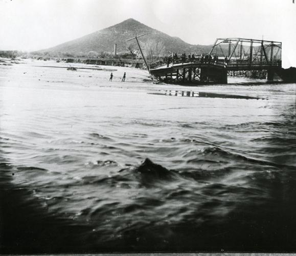
The Congress Street bridge over the Santa Cruz River near Sentinel Peak in Tucson washed out during flooding in 1915.
A prospective flood would have to be "pretty epic" to justify clearing the trees, Casebier said. He grew up in Flagstaff and remembers the Rio de Flagstaff having a 50-year flood in the early 1990s. Floodwaters drained onto neighboring golf courses and created a huge lake.
"It was a once-in-a-lifetime type flood. We're probably due for that here. But something that epic is out of your control," Casebier said. "If something happens, you just deal with it."
Another first floor resident, A.J. Harris, said he's not that nervous about the flood risk, but thinks clearing the river channel to reduce it would be beneficial.
"I couldn't really care less about the trees," he said.
Down at Kroeger Lane south of Congress Street, Andelia Muniz's great-grandson Julian Mendez wants the trees removed — "it should be safety first." Muniz counters, "Take a chance. I think the water won't come any higher."

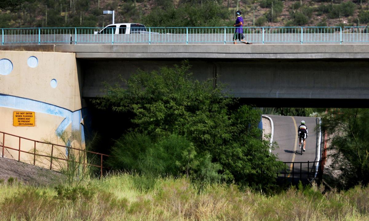
As crews work on the Sunset Road bridge over the Santa Cruz River in February, 2017. It is the newest bridge over the river.
Weighing the risk
To evaluate the flood risk, county consultant Haller used computer models to compare the 100-year floodplain's size based on a variety of scenarios for vegetation clearing.
— In the river's current condition, the floodplain extends outside the river from Grant to 22nd. Its 159 buildings have an assessed value of $59.3 million.
— Under a "flood risk optimization" scenario, sediment and vegetation would be removed only from areas near where flooding would most likely damage private property. The city's Agua Dulce project would proceed. That would leave 92 buildings assessed at $36.5 million in the floodplain.
— With enough vegetation and soil removed to return the Santa Cruz to conditions of the 1980s and with no Agua Dulce, 39 buildings worth nearly $17.8 million would remain in the floodplain.
— A plan to save the biggest trees and have Agua Dulce would leave 136 buildings worth $59.6 million in the floodplain.
Flood control officials said they have no timetable for the clearing work beyond the Grant-Speedway segment. They'll talk to neighbors and work with Tucson officials on that because the city owns the river channel through downtown.
A 2014 city-county agreement, under which the county took over flood maintenance of the Santa Cruz, requires the flood district to get city approval of a maintenance plan for city-owned lands on the river. City officials have asked the flood control district for more information about the channel maintenance options, said Lane Mandle, the city's communications coordinator.
As for Agua Dulce, a memo from Flood Control District Director Suzanne Shields said that, while it would create a more aesthetically pleasing environment, it would increase risks to roads, bridges, parks and landfills and private land along the river.
Yet Pima County flood control officials and Tucson Water agree that work on the project's first phase — releasing effluent at 29th Street — won't increase flooding risks downtown. That's partly because the river there is wide, giving water and sediment more room. Tucson Water hopes to start putting effluent there on Memorial Day 2019.
But the next leg, releasing effluent at Cushing Street, is more problematic because that stretch of river is narrower and lined with far more development, the agencies say.