

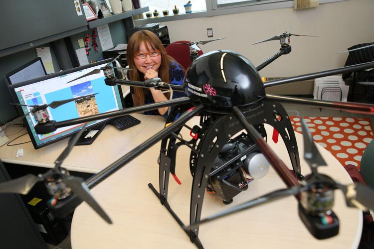
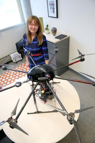
FLAGSTAFF — The machine perched on Teky Sankey’s cabinet looks like a giant bionic spider, with four legs and eight propeller-tipped arms extending from a sleek dome of a body.
Attached to the belly of the dome is a sophisticated suite of imaging, data storage and GPS devices.
And perhaps the coolest part is that the spider-like contraption can fly.
The octocopter is the newest contributor to Sankey’s collection of satellite and airplane-based data. The Northern Arizona University professor’s research focuses on analyzing images collected by remote imaging sensors on various aerial devices in order to measure the effects of human and natural forces acting on the landscape.
Her latest project analyzed thousands of images of northern Arizona’s forests to help confirm a concept many others have spent years measuring on the ground: that thinning and prescribed burning is remarkably effective in restoring the health and functionality of forest watersheds.
Using the images collected from satellites circling the Earth as well as others taken by an airplane, Sankey was able to estimate historical snow cover across northern Arizona and compare the amount of snow cover in forests that received restoration treatment like thinning and prescribed fire with those that didn’t.
She found that sites where trees had been thinned had about double the snow cover of non-treated sites. That means twice as much snow soaking into soils, benefiting plant roots and groundwater tables, instead of landing on tree canopies and evaporating away.
“Especially for our state, that’s a big deal,” she said.
Sankey’s analysis found that about 24 percent canopy cover was ideal to allow a maximum amount of snow to reach the forest floor while providing enough shade to keep the snow around for the longest amount of time.
That number is about equal to historical canopy coverage in the region, Sankey said.
“It’s interesting that sweet spot is also what we would naturally have if we didn’t have fire exclusion and things like that,” she said.
Sankey’s findings were published in the journal Remote Sensing of Environment in September.
The octocopter will expand upon that research, Senkey said. Among the drone’s measuring devices is a lidar sensor that can produce 3-dimensional images. That will allow Sankey to measure things like snow depth, tree height and tree canopy volume, which can help estimate the amount of snow moisture on the ground, timber harvest yield and carbon storage in a forest.
Also onboard the machine is a hyperspectral sensor that records hundreds of wavelengths of reflected sunlight, enabling Sankey to differentiate between various species of plants. Sankey explained that plants have unique ways they reflect the sun’s light based on factors like the chemical components and levels of photosynthetic activity inside the leaves.
Once it’s off the ground, the octocopter machine flies according to a pre-programmed flight path, but because it carries so much equipment, it can only make trips up to nine minutes or about 600 meters, she said.
The impetus for Sankey’s current research was the Four Forest Restoration Initiative, the 2.4-million acre project using mechanical means as well as prescribed and managed fire to restore forests to their historical condition.
“From a scientific perspective and an ecological perspective I wanted to know what is restoration doing and how it is going?” she said.
Her study of the effects of forest restoration on soil moisture also caught the interest of the Bureau of Reclamation and the agency funded Sankey’s analysis of snow cover images over northern Arizona.
Another use of Sankey’s data captured from the sky is to complement similar research happening on the ground, she said. The two sources of data help validate each other, she said.
Sankey is among a growing number of scientists turning to remote sensing equipment to get a big-picture view of shifts across the landscape. In California, in the context of historic drought conditions, researchers are using airborne sensors to measure groundwater depletion, snowpack and the chemical composition of the tree canopy. In Idaho, scientists have deployed drones to map remote landscapes in an effort to better restore and reseed burned areas according to their original vegetation composition.
Closer to home, U.S. Geological Survey researchers in Flagstaff have used unmanned aerial vehicles to create 3-dimensional maps of river channels, which allow water modelers to project what path waters will take during heavy rain and flood events, said John Vogel, a USGS geographer. Future drone-related projects the USGS has planned in the region include aerial mapping of sandbars in the Colorado River to monitor how they build up and erode according to operations of Glen Canyon Dam, Vogel said.

