


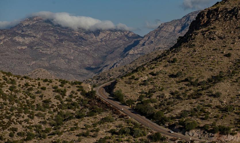
Some recreational areas along Catalina Highway have reopened, about six weeks after the massive Bighorn Fire was finally put out.
The fire started June 5 and burned about 120,000 acres in the Catalina Mountains by the time the Forest Service declared it fully contained on July 23.
The Forest Service reopened some recreational areas beginning Tuesday night.
Visitors can use the areas, but services like restrooms and trash pickup still are unavailable, officials said. Visitors are asked to clean up after themselves.
However, restrooms and trash services will resume at four recreation sites on Thursday, Sept. 3: General Hitchcock Campground, Inspiration Rock Picnic Area, Alder Picnic Area and Box Elder Picnic Area.
The order reopening some areas is expected to be in effect until Nov. 1, though changes can be made.
Photos: The Bighorn Fire burn scar in the Santa Catalina Mountains
Bighorn Fire Burn Scar, hiking trails
Updated
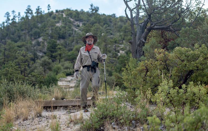
Gregg Sasek, dispersed recreation manager for the Coronado National Forest Santa Catalina Ranger District, demonstrates how ground along the Palisade Trail has been burnt out making it easy for hikers to sink a leg into the soil, on Aug. 12, 2020. Various dangers are still being accessed throughout the Coronado National Forest as a result of the Bighorn Fire. Pool photo by Josh Galemore / Arizona Daily Star
Bighorn Fire Burn Scar, hiking trails
Updated
Santa Catalina District Ranger CJ Woodard looks at the burn scar caused by the Bighorn Fire along the Palisade Trail in the Santa Catalina Ranger District of the Coronado National Forest, on Aug. 12, 2020. Pool photo by Josh Galemore / Arizona Daily Star
Bighorn Fire Burn Scar, hiking trails
Updated
A scorched tree along the Palisade Trail in the Santa Catalina Ranger District of the Coronado National Forest, on Aug. 12, 2020. Dangers including burnt vegetation, unstable trees and loose soil as a result of the Bighorn Fire are being accessed by the Forest Service before trails in the area are opened to the public. Pool photo by Josh Galemore / Arizona Daily Star
Bighorn Fire Burn Scar, hiking trails
Updated
A tree uprooted by burnt roots and soil as a result of the Bighorn Fire along the Palisade Trail in the Santa Catalina Ranger District of the Coronado National Forest, on Aug. 12, 2020. Pool photo by Josh Galemore / Arizona Daily Star
Bighorn Fire Burn Scar, hiking trails
Updated
Gregg Sasek, dispersed recreation manager with the Coronado National Forest Santa Catalina Ranger District, leads media and other Forest Service workers along the Palisade Trail to showcase various types of damage done to wilderness area as a result of the Bighorn Fire, on Aug. 12, 2020. Pool photo by Josh Galemore / Arizona Daily Star
Bighorn Fire Burn Scar, hiking trails
Updated
A scorched tree along the Palisade Trail in the Santa Catalina Ranger District of the Coronado National Forest, on Aug. 12, 2020. Dangers including burnt vegetation, unstable trees and loose soil as a result of the Bighorn Fire are being accessed by the Forest Service before trails in the area are opened to the public. Pool photo by Josh Galemore / Arizona Daily Star
Bighorn Fire Burn Scar, hiking trails
Updated
Ponderosa Pines charred by the Bighorn Fire stand along the Palisade Trail in the Santa Catalina Ranger District of the Coronado National Forest, on Aug. 12, 2020. Pool photo by Josh Galemore / Arizona Daily Star
Bighorn Fire Burn Scar, hiking trails
Updated
A tree uprooted and burnt as a result of the Bighorn Fire along the Palisade Trail in the Santa Catalina Ranger District of the Coronado National Forest, on Aug. 12, 2020. Pool photo by Josh Galemore / Arizona Daily Star
Bighorn Fire Burn Scar, hiking trails
Updated
Gregg Sasek, dispersed recreation manager with the Coronado National Forest Santa Catalina Ranger District, carries a combi-tool (a woodland fire tool which combines a shovel and pick) as he leads media and other Forest Service personnel along the Palisade Trail to showcase various types of damage done to wilderness area as a result of the Bighorn Fire, on Aug. 12, 2020. Pool photo by Josh Galemore / Arizona Daily Star
Bighorn Fire Burn Scar, hiking trails
Updated
Forest Service personnel and media walk through a burn scar caused by the Bighorn Fire along the Palisade Trail in the Santa Catalina Ranger District of the Coronado National Forest, on Aug. 12, 2020. Pool photo by Josh Galemore / Arizona Daily Star
Bighorn Fire Burn Scar, hiking trails
Updated
Forest Service personnel and media walk through a burn scar caused by the Bighorn Fire along the Palisade Trail in the Santa Catalina Ranger District of the Coronado National Forest, on Aug. 12, 2020. Pool photo by Josh Galemore / Arizona Daily Star
Bighorn Fire Burn Scar, hiking trails
Updated
Gregg Sasek, dispersed recreation manager with the Coronado National Forest Santa Catalina Ranger District, leads media and other Forest Service workers along the Palisade Trail to showcase various types of damage done to wilderness area as a result of the Bighorn Fire, on Aug. 12, 2020. Pool photo by Josh Galemore / Arizona Daily Star
Bighorn Fire Burn Scar, hiking trails
Updated
A fern sprouts from the soil in a burnt out area along the Palisade Trail in the Santa Catalina Ranger District of the Coronado National Forest, on Aug. 12, 2020. Pool photo by Josh Galemore / Arizona Daily Star
Bighorn Fire Burn Scar, hiking trails
Updated
Gregg Sasek, dispersed recreation manager with the Coronado National Forest Santa Catalina Ranger District, checks tree tops for signs of burn while leading media and other Forest Service workers along the Palisade Trail to showcase various types of damage done to wilderness area as a result of the Bighorn Fire, on Aug. 12, 2020. Pool photo by Josh Galemore / Arizona Daily Star
Bighorn Fire Burn Scar, hiking trails
Updated
A burn scar along the Palisade Trail in the Santa Catalina Ranger District of the Coronado National Forest, on Aug. 12, 2020. Pool photo by Josh Galemore / Arizona Daily Star
Bighorn Fire Burn Scar, hiking trails
Updated
A tree base scorched by the Bighorn Fire along the Palisade Trail in the Santa Catalina Ranger District of the Coronado National Forest, on Aug. 12, 2020. The weakening of the base makes it easier for trees to fall and are a serious danger to hikers. Pool photo by Josh Galemore / Arizona Daily Star
Bighorn Fire Burn Scar, hiking trails
Updated
Gregg Sasek, dispersed recreation manager with the Coronado National Forest Santa Catalina Ranger District, walks by a "leaner" (an uprooted tree hung up on another tree or object) as he leads media and other Forest Service workers along the Palisade Trail to showcase various types of damage done to wilderness area as a result of the Bighorn Fire, on Aug. 12, 2020. Pool photo by Josh Galemore / Arizona Daily Star
Bighorn Fire Burn Scar, hiking trails
Updated
A burn scar from the Bighorn Fire along a hilltop near the Palisade Trail in the Santa Catalina Ranger District of the Coronado National Forest, on Aug. 12, 2020. Pool photo by Josh Galemore / Arizona Daily Star
Bighorn Fire Burn Scar, hiking trails
Updated
Scorched pine needles along the Palisade Trail in the Santa Catalina district of the Coronado National Forest, on Aug. 12, 2020. Pool photo by Josh Galemore / Arizona Daily Star
Bighorn Fire
Updated
Bighorn Fire scar north of Summerhaven, Ariz, right, on July 15, 2020. The Mt. Lemmon Fire station is top center in the photo.
Bighorn Fire
Updated
Bighorn Fire in the Santa Catalina Mountains below Summerhaven, Ariz, right, on July 15, 2020.
Bighorn Fire
Updated
Bighorn Fire scar in the Santa Catalina Mountains north of Summerhaven (lower right) on July 15, 2020.
Bighorn Fire
Updated
Bighorn Fire scar in the Santa Catalina Mountains below the town of Summerhaven on July 15, 2020.
Bighorn Fire
Updated
The Mt. Lemmon Control Road cuts through the Bighorn Fire scar on the north side of the Santa Catalina Mountains near Oracle, Ariz., on July 15, 2020.
Bighorn Fire
Updated
Bighorn Fire scar below Mt. Lemmon in the Santa Catalina Mountains on July 15, 2020.
Bighorn Fire
Updated
Bighorn Fire scar area: Cañada del Oro basin looking south at Samaniego Ridge in the Santa Catalina Mountains north of Tucson on July 1, 2020. The summit of Mt Lemmon is at left.
Bighorn Fire
Updated
The Bighorn Fire scar area shown looking from East Ski Run toward Oracle Ridge, left, and Sanmaniego Ridge, right, in the Santa Catalina Mountains north of Tucson.
Bighorn Fire
Updated
Bighorn Fire scar area: South face of Mt Kimball on July 3, 2020, in the Santa Catalina Mountains north of Tucson.
Bighorn Fire
Updated
Bighorn Fire scar area: Regional Flood Control Staff installing a new real-time ALERT rainfall monitoring site in the burn area in the Santa Catalina Mountains north of Tucson in July, 2020. These are the backbone of the flash flood warning system.
Bighorn Fire
Updated
Charred debris from the Bighorn Fire moves down the Cañada del Oro Wash after a monsoon storm on July 15, 2020.
Bighorn Fire
Updated
Charred debris from the Bighorn Fire moves down the Cañada del Oro Wash after a monsoon storm on July 15, 2020.

