


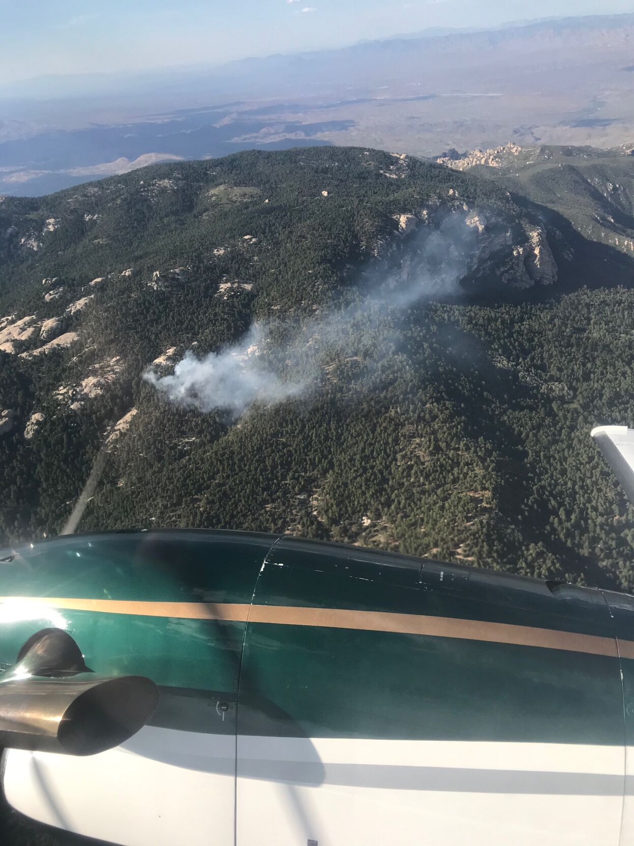
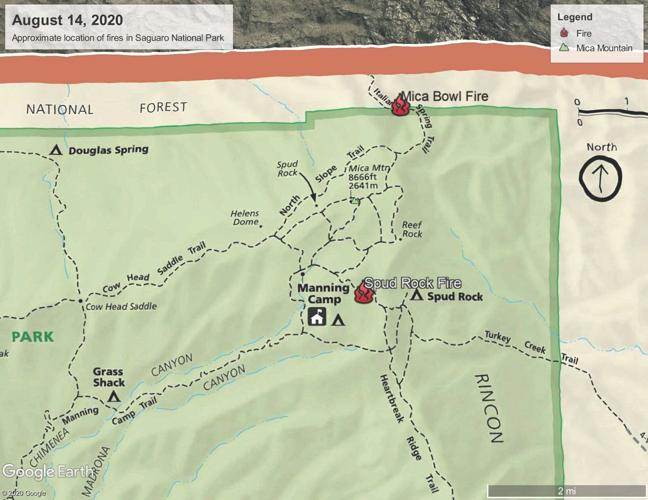
Two lightning-sparked wildfires are burning in the Saguaro National Park's Rincon Mountains east of Tucson.
The fires are burning in remote areas, in high elevations within the Saguaro Wilderness and were started by lightning strikes from a thunderstorm that passed through the area on Thursday, according to a news release from the park.
Smoke may be visible from Tucson, Redington Pass, Mescal and surrounding areas.
The Spud Rock Fire was reported at about 4:30 p.m. Thursday and is about 10 acres in size. It is estimated to be located within a section of network trails in the Manning Camp area, just west of the junction of the Heartbreak Ridge Trail and the Switchback Trail that leads to the Spud Rock campground.
The Mica Bowl Fire was reported Friday about 9 a.m. It is estimated to be about two acres in size. The preliminary location is estimated to be just west of the Italian Springs Trail near the park boundary with the Coronado National Forest.
Firefighters will be hiking in to the remote back-country area to assess the fires Saturday so fire managers can take action as needed.
There are no immediate threats to structures at this time. The Mica Bowl Fire is estimated to be about a mile southeast of Manning Camp, a back-country cabin located in Saguaro National Park.
There are no trail closures at this time. Back-country hikers and campers should be aware of their surroundings and are encouraged to check with the Rincon Mountain Visitor Center for current conditions and updates on potential trail closures.
For updated information visit inciweb.nwcg.gov/ or call the park’s fire hotline at (520) 733-5150.
Photos: The Bighorn Fire burn scar in the Santa Catalina Mountains
Bighorn Fire Burn Scar, hiking trails
Updated
Gregg Sasek, dispersed recreation manager for the Coronado National Forest Santa Catalina Ranger District, demonstrates how ground along the Palisade Trail has been burnt out making it easy for hikers to sink a leg into the soil, on Aug. 12, 2020. Various dangers are still being accessed throughout the Coronado National Forest as a result of the Bighorn Fire. Pool photo by Josh Galemore / Arizona Daily Star
Bighorn Fire Burn Scar, hiking trails
Updated
Santa Catalina District Ranger CJ Woodard looks at the burn scar caused by the Bighorn Fire along the Palisade Trail in the Santa Catalina Ranger District of the Coronado National Forest, on Aug. 12, 2020. Pool photo by Josh Galemore / Arizona Daily Star
Bighorn Fire Burn Scar, hiking trails
Updated
A scorched tree along the Palisade Trail in the Santa Catalina Ranger District of the Coronado National Forest, on Aug. 12, 2020. Dangers including burnt vegetation, unstable trees and loose soil as a result of the Bighorn Fire are being accessed by the Forest Service before trails in the area are opened to the public. Pool photo by Josh Galemore / Arizona Daily Star
Bighorn Fire Burn Scar, hiking trails
Updated
A tree uprooted by burnt roots and soil as a result of the Bighorn Fire along the Palisade Trail in the Santa Catalina Ranger District of the Coronado National Forest, on Aug. 12, 2020. Pool photo by Josh Galemore / Arizona Daily Star
Bighorn Fire Burn Scar, hiking trails
Updated
Gregg Sasek, dispersed recreation manager with the Coronado National Forest Santa Catalina Ranger District, leads media and other Forest Service workers along the Palisade Trail to showcase various types of damage done to wilderness area as a result of the Bighorn Fire, on Aug. 12, 2020. Pool photo by Josh Galemore / Arizona Daily Star
Bighorn Fire Burn Scar, hiking trails
Updated
A scorched tree along the Palisade Trail in the Santa Catalina Ranger District of the Coronado National Forest, on Aug. 12, 2020. Dangers including burnt vegetation, unstable trees and loose soil as a result of the Bighorn Fire are being accessed by the Forest Service before trails in the area are opened to the public. Pool photo by Josh Galemore / Arizona Daily Star
Bighorn Fire Burn Scar, hiking trails
Updated
Ponderosa Pines charred by the Bighorn Fire stand along the Palisade Trail in the Santa Catalina Ranger District of the Coronado National Forest, on Aug. 12, 2020. Pool photo by Josh Galemore / Arizona Daily Star
Bighorn Fire Burn Scar, hiking trails
Updated
A tree uprooted and burnt as a result of the Bighorn Fire along the Palisade Trail in the Santa Catalina Ranger District of the Coronado National Forest, on Aug. 12, 2020. Pool photo by Josh Galemore / Arizona Daily Star
Bighorn Fire Burn Scar, hiking trails
Updated
Gregg Sasek, dispersed recreation manager with the Coronado National Forest Santa Catalina Ranger District, carries a combi-tool (a woodland fire tool which combines a shovel and pick) as he leads media and other Forest Service personnel along the Palisade Trail to showcase various types of damage done to wilderness area as a result of the Bighorn Fire, on Aug. 12, 2020. Pool photo by Josh Galemore / Arizona Daily Star
Bighorn Fire Burn Scar, hiking trails
Updated
Forest Service personnel and media walk through a burn scar caused by the Bighorn Fire along the Palisade Trail in the Santa Catalina Ranger District of the Coronado National Forest, on Aug. 12, 2020. Pool photo by Josh Galemore / Arizona Daily Star
Bighorn Fire Burn Scar, hiking trails
Updated
Forest Service personnel and media walk through a burn scar caused by the Bighorn Fire along the Palisade Trail in the Santa Catalina Ranger District of the Coronado National Forest, on Aug. 12, 2020. Pool photo by Josh Galemore / Arizona Daily Star
Bighorn Fire Burn Scar, hiking trails
Updated
Gregg Sasek, dispersed recreation manager with the Coronado National Forest Santa Catalina Ranger District, leads media and other Forest Service workers along the Palisade Trail to showcase various types of damage done to wilderness area as a result of the Bighorn Fire, on Aug. 12, 2020. Pool photo by Josh Galemore / Arizona Daily Star
Bighorn Fire Burn Scar, hiking trails
Updated
A fern sprouts from the soil in a burnt out area along the Palisade Trail in the Santa Catalina Ranger District of the Coronado National Forest, on Aug. 12, 2020. Pool photo by Josh Galemore / Arizona Daily Star
Bighorn Fire Burn Scar, hiking trails
Updated
Gregg Sasek, dispersed recreation manager with the Coronado National Forest Santa Catalina Ranger District, checks tree tops for signs of burn while leading media and other Forest Service workers along the Palisade Trail to showcase various types of damage done to wilderness area as a result of the Bighorn Fire, on Aug. 12, 2020. Pool photo by Josh Galemore / Arizona Daily Star
Bighorn Fire Burn Scar, hiking trails
Updated
A burn scar along the Palisade Trail in the Santa Catalina Ranger District of the Coronado National Forest, on Aug. 12, 2020. Pool photo by Josh Galemore / Arizona Daily Star
Bighorn Fire Burn Scar, hiking trails
Updated
A tree base scorched by the Bighorn Fire along the Palisade Trail in the Santa Catalina Ranger District of the Coronado National Forest, on Aug. 12, 2020. The weakening of the base makes it easier for trees to fall and are a serious danger to hikers. Pool photo by Josh Galemore / Arizona Daily Star
Bighorn Fire Burn Scar, hiking trails
Updated
Gregg Sasek, dispersed recreation manager with the Coronado National Forest Santa Catalina Ranger District, walks by a "leaner" (an uprooted tree hung up on another tree or object) as he leads media and other Forest Service workers along the Palisade Trail to showcase various types of damage done to wilderness area as a result of the Bighorn Fire, on Aug. 12, 2020. Pool photo by Josh Galemore / Arizona Daily Star
Bighorn Fire Burn Scar, hiking trails
Updated
A burn scar from the Bighorn Fire along a hilltop near the Palisade Trail in the Santa Catalina Ranger District of the Coronado National Forest, on Aug. 12, 2020. Pool photo by Josh Galemore / Arizona Daily Star
Bighorn Fire Burn Scar, hiking trails
Updated
Scorched pine needles along the Palisade Trail in the Santa Catalina district of the Coronado National Forest, on Aug. 12, 2020. Pool photo by Josh Galemore / Arizona Daily Star
Bighorn Fire
Updated
Bighorn Fire scar north of Summerhaven, Ariz, right, on July 15, 2020. The Mt. Lemmon Fire station is top center in the photo.
Bighorn Fire
Updated
Bighorn Fire in the Santa Catalina Mountains below Summerhaven, Ariz, right, on July 15, 2020.
Bighorn Fire
Updated
Bighorn Fire scar in the Santa Catalina Mountains north of Summerhaven (lower right) on July 15, 2020.
Bighorn Fire
Updated
Bighorn Fire scar in the Santa Catalina Mountains below the town of Summerhaven on July 15, 2020.
Bighorn Fire
Updated
The Mt. Lemmon Control Road cuts through the Bighorn Fire scar on the north side of the Santa Catalina Mountains near Oracle, Ariz., on July 15, 2020.
Bighorn Fire
Updated
Bighorn Fire scar below Mt. Lemmon in the Santa Catalina Mountains on July 15, 2020.
Bighorn Fire
Updated
Bighorn Fire scar area: Cañada del Oro basin looking south at Samaniego Ridge in the Santa Catalina Mountains north of Tucson on July 1, 2020. The summit of Mt Lemmon is at left.
Bighorn Fire
Updated
The Bighorn Fire scar area shown looking from East Ski Run toward Oracle Ridge, left, and Sanmaniego Ridge, right, in the Santa Catalina Mountains north of Tucson.
Bighorn Fire
Updated
Bighorn Fire scar area: South face of Mt Kimball on July 3, 2020, in the Santa Catalina Mountains north of Tucson.
Bighorn Fire
Updated
Bighorn Fire scar area: Regional Flood Control Staff installing a new real-time ALERT rainfall monitoring site in the burn area in the Santa Catalina Mountains north of Tucson in July, 2020. These are the backbone of the flash flood warning system.
Bighorn Fire
Updated
Charred debris from the Bighorn Fire moves down the Cañada del Oro Wash after a monsoon storm on July 15, 2020.
Bighorn Fire
Updated
Charred debris from the Bighorn Fire moves down the Cañada del Oro Wash after a monsoon storm on July 15, 2020.

