


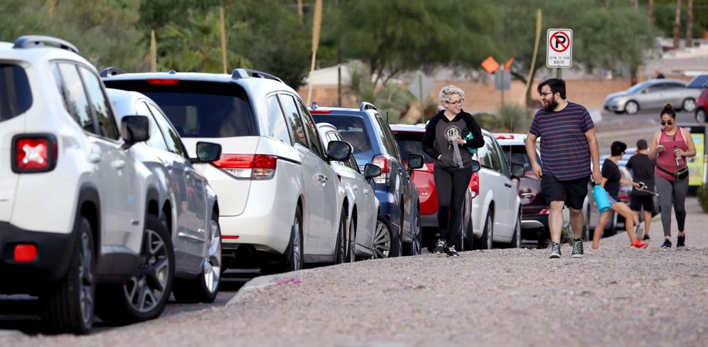
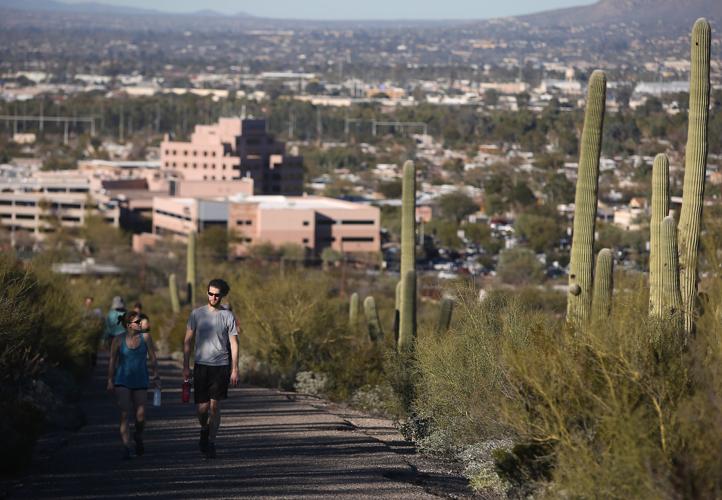

It’ll take you about 700 feet high at its peak, but before heading up Tumamoc Hill visitors are likely to spend a chunk of time finding a place to park.
More than 1,000 people are drawn to the 860-acre U.S. National Historic Landmark each day. And parking along West Anklam Road can be difficult during the 4 a.m. to 10 p.m. hours of operation.
“If you come up here between 5 p.m. and 6 p.m., you’d be surprised. You’d be like, ‘Well, there’s a party up there. I’m going to go up there because something’s going on,’” said Elizabeth Santamaria.
But security staff at Carondelet St. Mary’s Hospital, which is next door to Tumamoc, recently reminded visitors that their parking lots are not the remedy for parking problems.
“We want to ensure ease of access for hospital staff and visitors. In the hospital lot, notices are meant to help educate the public that nurse and staff parking is important to our ability to provide care, and the hospital reserves the right to enforce parking rules,” hospital officials said in a statement.
Earlier this month, flyers were handed out to visitors about unauthorized use of the hospital’s parking lots. Within the formal notice to visitors was a reminder that vehicles could be towed.
How the hospital security department is identifying vehicles used by Tumamoc visitors was not disclosed, but tow fees are expensive.
Santamaria, who regularly enjoys the scenic 1.5-mile path up the hill, said her daughter’s vehicle was towed after she parked at one of the medical clinics after closing time.
It cost her daughter at least $200 to get the vehicle out of impound.
“I understand that during the daytime if they have a lot of patients that can’t park trying to go to a doctor’s appointment. But after they close at 5 o’clock, why don’t they allow them to park?” Santamaria said. “That’s when it gets more packed over here. I don’t understand that, they should have some extra parking for people here.”
The threat of towing, she says, still does not stop all walkers from using the medical parking.
“In the evening, you can sit there and watch people’s vehicles be towed. The tow truck just comes and drives around like it knows when to come,” she said.
The hospital is working with the city to find a solution to the parking situation.
“Hospital leaders are actively engaged with the city to discuss parking options for those who visit Tumamoc Hill, and we look forward to a productive dialogue,” a statement from St. Mary’s said.
At Councilwoman Regina Romero’s Ward 1 office, her staff has looked at possible remedies.
“My office is aware of St. Mary’s decision and I have asked city staff to work with the U of A and St. Mary’s to try to come up with a plan for alternative parking,” Romero said in a statement.
Tumamoc Hill land adjacent to the road is mainly operated by the University of Arizona as a study site.
“Fifteen hundred people a day hike the hill and it is important to our city that we, as a community, continue to offer this amenity to the people of Tucson,” Romero said in the statement.
Down the Road
Motorists should expect minor delays starting Monday near the Tanque Verde and Tanque Verde Loop Road intersection project.
From 6 a.m. to 4 p.m., construction crews will use heavy equipment to remove structures and obstruction near the site.
After the project’s completion in spring 2020, motorists will find a “four-legged signalized intersection,” with sidewalks and Americans with Disabilities pedestrian access ramps and street lighting.
Motorists should use caution and watch for personnel in the area.
Photos: Tucson streets through the years
Photos: Tucson streets through the years
Tucson streets
Updated
Traffic on East Grant Road in Feb., 1981. Arizona Daily Star file
Tucson streets
Updated
Speedway Boulevard, looking east from Country Club, probably in the mid-1970s. Arizona Daily Star file
Tucson streets
Updated
Speedway Boulevard in Dec. 1957. Arizona Daily Star file
Tucson streets
Updated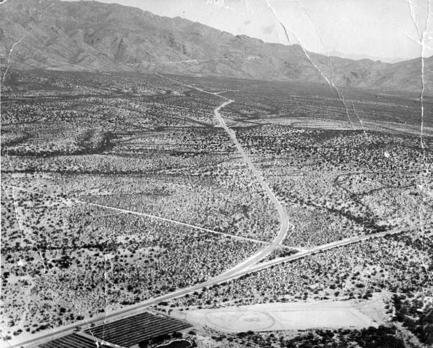
Undated aerial photo fo Tanque Verde Road and the Catalina Highway. Arizona Daily Star file
Tucson streets
Updated
Old Oracle Road bridge over the Rillito River in 1950. Arizona Daily Star file
Tucson streets
Updated
Ina Road under construction looking east toward La Ca–ada Drive in December, 1980. By Joe Vitti / Arizona Daily Star
Tucson streets
Updated
A temporary bridge over Interstate 10 at 6th Avenue that was used while the new bridge was being built in 1990. Benjie Sanders/ Arizona Daily Star
Tucson streets
Updated
Flooding under the stone Stone Ave. underpass caught a city bus. Photo probably from the 1970s. Arizona Daily Star
Tucson streets
Updated
Undated photo of Congress Street, probably in the 1950s. Arizona Daily Star
Tucson streets
Updated
East Broadway looking East from an unknown intersection on July 21, 1958. Arizona Daily Star
Tucson streets
Updated
Undated photo of Congress Street downtown before a city street lighting project in the 1950s. Arizona Daily Star
Tucson streets
Updated
The railroad crossings at 22nd Street, prior to construction of the overpass. Arizona Daily Star
Tucson streets
Updated
Most likely Alvernon Way north of 29th Street in the early 1980s. Arizona Daily Star

