


Photos: Images from Mars HiRise camera
- Updated
Newly released images of the Mars surface taken by the Mars HiRise camera aboard the Mars Reconnaissance Orbiter.
Mars HiRise images
- NASA / JPL / University of Arizona
- Updated
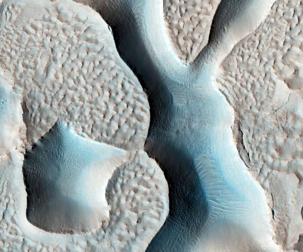
Ridges and Troughs in Deuteronilus Mensae - (17 June 2016, 189 km above the surface). The ridges here are very sharp looking and the troughs are large and deep.
Mars HiRise images
- NASA / JPL / University of Arizona
- Updated
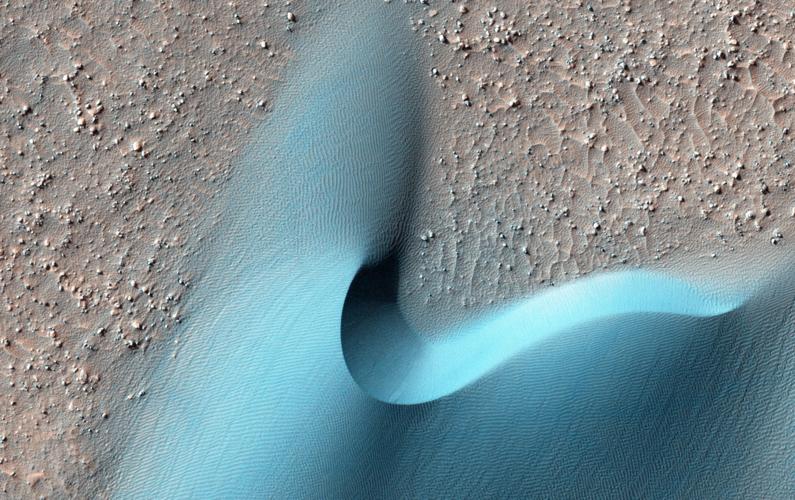
This enhanced photo, taken from about 100 miles above Mars’ surface, shows dunes within Arkhangelsky Crater. Blue typically indicates basalt. This is what is known as a barchan dune.

Mars HiRise images
- NASA / JPL / University of Arizona
- Updated
Sedimentary Processes North of Hellas Region - (5 June 2016, 160 km above the surface). An erosional window into sedimentary deposits.

Mars HiRise images
- NASA / JPL / University of Arizona
- Updated
Eos Chasma - (12 June 2016, 165 km above the surface). Beautiful fans of sediment spilling away from an outcrop atop a large mound. Eos Chasma is in the southern part of Valles Marineris.

Mars HiRise images
- NASA / JPL / University of Arizona
- Updated
A Ridge and Layered Bedrock - (18 June 2016, 189 km above the surface). Prominent are the bedrock layers you can see under the ridge.

Mars HiRise images
- NASA / JPL / University of Arizona
- Updated
Arcadia Planitia - (8 June 2016, 160 km above the surface). This features a very ancient and in-filled crater in Arcadia Planitia, known for being fairly smooth due to old lava flows.

Mars HiRise images
- NASA / JPL / University of Arizona
- Updated
Candidate Recent Impact Site - (18 June 2016, 189 km above the surface). A favorite target of HiRISE is to find possible new impact sites (we�ve catalogued hundreds) where we can also see exposed ice, which appears as blue in enhanced color images.

Mars HiRise images
- NASA / JPL / University of Arizona
- Updated
Spiders on Sastrugi! - (21 June 2016, 154 km above the surface). A good follow up the previous image, where defrosting carbon dioxide can create these sprawling channels called �araneiform,� although �spider� is often a more relatable term. This is another polar image.
Mars HiRise images
- NASA / JPL / University of Arizona
- Updated
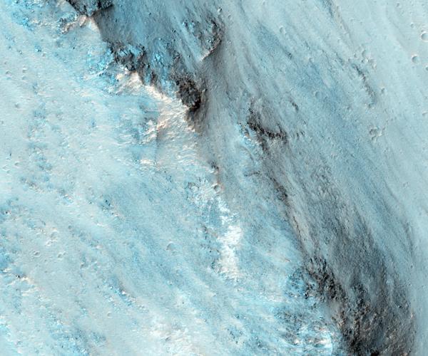
Excellent Bedrock Exposures in the South Wall of Capri Chasma - (11 June 2016, 163 km above the surface). This region is at the eastern end of giant Valles Marineris, the largest canyon the Solar System.

Mars HiRise images
- NASA / JPL / University of Arizona
- Updated
Steep Slope in Eastern Noctis Labyrinthus - (14 June 2016, 163 km above the surface). Latin for �Labyrinth of the Night,� and an area that might be promising for locating RSL, or recurring slope lineae.

Mars HiRise images
- NASA / JPL / University of Arizona
- Updated
Frosty Dunes - (19 June 2016, 156 km above the surface). Spots everywhere, made by sublimation, where a solid transforms directly to a gas (in this case, carbon dioxide ice). When that happens, darker subsurface material is exposed and eventually fades over time.
Mars HiRise images
- NASA / JPL / University of Arizona
Candidate Recent Impact Site - (18 June 2016, 189 km above the surface). A favorite target of HiRISE is to find possible new impact sites (we�ve catalogued hundreds) where we can also see exposed ice, which appears as blue in enhanced color images.
Mars HiRise images
- NASA / JPL / University of Arizona
Spiders on Sastrugi! - (21 June 2016, 154 km above the surface). A good follow up the previous image, where defrosting carbon dioxide can create these sprawling channels called �araneiform,� although �spider� is often a more relatable term. This is another polar image.
Mars HiRise images
- NASA / JPL / University of Arizona
Excellent Bedrock Exposures in the South Wall of Capri Chasma - (11 June 2016, 163 km above the surface). This region is at the eastern end of giant Valles Marineris, the largest canyon the Solar System.
Mars HiRise images
- NASA / JPL / University of Arizona
Steep Slope in Eastern Noctis Labyrinthus - (14 June 2016, 163 km above the surface). Latin for �Labyrinth of the Night,� and an area that might be promising for locating RSL, or recurring slope lineae.
Mars HiRise images
- NASA / JPL / University of Arizona
Frosty Dunes - (19 June 2016, 156 km above the surface). Spots everywhere, made by sublimation, where a solid transforms directly to a gas (in this case, carbon dioxide ice). When that happens, darker subsurface material is exposed and eventually fades over time.
As featured on

Scientists continue to analyze more than ten years of Mars images taken by the University of Arizona's HIRISE camera aboard NASA's Mars Reconnaissance Orbiter.
More information
- UA-run HiRISE takes photos of Earth, moon as viewed from Mars orbit
- The search for water on Mars has intrigued scientists for centuries
- Cienega High students readying for work on total solar eclipse movie
- Hubble, with Arizona scientists in big roles, 'changed the way we look at the universe'
- Tucson-based institute maps ice on Mars to fuel future missions


View this profile on Instagram#ThisIsTucson 🌵 (@this_is_tucson) • Instagram photos and videos
Most viewed stories
-
Over 30 fun events happening in Tucson March 27-29!
-
A Jets fan and a Bills fan walk into a bar: My tasty journey at Anchor Bar
-
New Eats! 20 new restaurants that opened up in Tucson this winter 🍽️
-
Bloomfest celebrates palo verde blooms and Tucson culture
-
The #ThisIsTucson Snail Mail Club is here! Here's how you can get a little piece of Tucson in your mailbox 💗
-
OaxaRico opened their first brick-and-mortar, serving up delicious mole and gorditas
-
Over 40 exciting events to check out this weekend! 🌱
-
Nearly 90 fun events happening in March! 🌺
-
$25 challenge kicks off at Tucson’s Pop Cycle
-
Snickerdoodle pancakes all the time! Baja Cafe is creating boxed mixes featuring their beloved pancake flavors