


Dark lines that appear seasonally on sunny Martian slopes could be evidence of flowing water, University of Arizona scientists say in a paper published today in the journal Science.
The lines showed up when an undergraduate researcher at the UA's Lunar and Planetary Laboratory created digital terrain models of portions of the surface of Mars, basically converting the two-dimensional images taken by the HiRISE camera aboard NASA's Mars Reconnaissance Orbiter into 3-D maps.
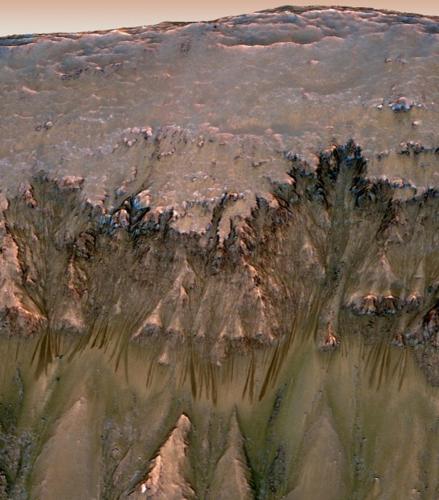
The lines, up to 5 yards wide and 200 meters in length, are not scientific evidence of flowing water, said UA planetary scientist Alfred McEwen, principal investigator for HiRISE.
But McEwen said at a NASA news conference Thursday that water is the only explanation for them that makes sense.
"This is the best evidence we have to date of liquid water occurring today on Mars," said Phil Christensen, a geophysicist at Arizona State University, who also spoke at the news conference.
If it is water, McEwen said, it would be extremely salty - salty enough to remain solid at sub-zero temperatures and not boil away at higher temperatures in the Martian atmosphere.
"So we have this circumstantial evidence of flowing water on Mars. We have no direct evidence," said McEwen.
HiRISE, in nearly six years of operation, has revealed many changes on the surface of Mars, including gullies that appear and disappear. The camera has even captured landslides on the Martian surface.
Until now, however, most of those surface alterations have been attributed to frozen gases such as carbon dioxide.
These new features appear in a region that would be "too hot for CO2 frost," said Shane Byrne, a UA planetary scientist who is also an author on the Science paper.
Spring and summer temperatures on the sunny side of craters in Mars' mid latitudes range from just below zero to about 80 degrees Fahrenheit.
Very briny water could remain liquid at those temperatures, said Byrne.
Byrne said project scientists went through "a process of elimination" after the lines were discovered, looking for any reason other than the presence of water to explain them. Nothing else made sense for the temperature and topography, he said.
Lujendra Ojha, the 21-year-old undergraduate whose work uncovered the lines, said he had gotten bored with his student job as image validator for HiRISE. "I had to make sure the images are good with no defects, really a tedious job," he said.
He asked McEwen for something different and was put to work on an independent project to make 3-D images from stereo images taken from slightly different positions.
He was the first to see the new features, said Byrne. "It shows some individual initiative," said Byrne, who said Ojha is "well on his way" to a career in planetary sciences.
"I just happened to be a lucky guy," said Ojha. "These features were there in the images but they are really small and unless you're looking for them, you might not see them."
Ojha moved to Tucson six years ago from Nepal and attended Tucson High School. He is a university senior in geosciences.
He did research at Tucson High and has been involved in several research projects at UA, he said.
"This is my first major publication," he said. "I'm thinking that this will help me carve my gateway to grad school."
DID YOU KNOW?
The HiRISE camera, developed at the University of Arizona, has been circling Mars aboard the Mars Reconnaissance Orbiter since March 2006.
The camera, whose full name is the High Resolution Imaging Science Experiment, has captured a series of historic and detailed pictures of Mars' surface and in 2008 captured an image of the Phoenix Mars Lander as it descended to the red planet.
Contact reporter Tom Beal at tbeal@azstarnet.com or 573-4158.

