


Yuma-area farmers are fighting a proposed set of Colorado River water use curbs, saying they favor urban users in Phoenix and Tucson even though the farmers have higher-priority rights to the water.
The disagreement means puts Arizona’s two biggest Colorado River water using sectors — big cities and farms — squarely at odds. And it’s happening at the same time Arizona and five other Colorado River Basin states are squaring off against California over how to shave millions of acre feet a year off total diversions of water from the overallocated, depleted river.
An attorney for the Yuma farmers, Wade Noble, wrote Arizona state water chief Tom Buschatzke recently that the farmers don’t agree with a number of key points in a proposal for river water cuts made by Arizona and all the other seven river basin states except California. Among them are how evaporation losses on the river will be counted against the farms’ legal access to river water, whether river water should be allocated to cities for “human health and safety” purposes and over cities’ ability to access river water they’ve temporarily stored in Lake Mead to prop up its water level.
In an interview, Noble said his biggest concern is that the six-state proposal appears to take hundreds of thousands of acre feet of river water Yuma irrigation districts have long held rights to and essentially turn it over to Central Arizona cities that legally have lower priorities for the water.
The large majority of crop acreage in Yuma has what’s called Priority 3 water rights to the river, whereas the Central Arizona Project has Priority 4 rights, the lowest available, he said.
The Yuma-area irrigation districts have rights to roughly 800,000 to 900,000 acre feet a year of river water. The CAP has historically had rights to at least 1.5 million acre feet a year of water. It’s cut its share to around 1 million acre feet annually in the past few years in response to earlier drought plans aimed at keeping Lake Mead from collapsing.
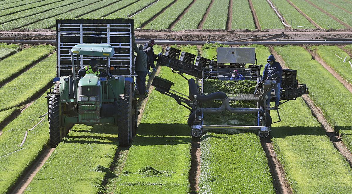
But taking too much water rights from river farmers could trigger a collapse of the agricultural industry there that grows winter vegetables sold across the U.S., Noble said. For one, about 95% of the country’s winter lettuce crop comes from Yuma, various experts have said.
“The industry can’t continue to function if you take out more than a certain percentage of the water,” he said. “I’m told you could take out 25% and keep the industry going. I don’t think people in Yuma County accept that. If you take it down, you take it down. The industry collapses.
“It’s not like you keep planting fewer veggies in the garden. It’s that the garden at some point dies.”
Buschatzke, director of the Arizona Department of Water Resources, declined last week to comment on Noble’s letter. It was written in late February on behalf of a coalition of Yuma-area irrigation districts.
But the farm-city split over water use curbs troubles Terry Goddard, president of the Central Arizona Project’s governing board. He sees a need for unity in the face of what could be a protracted struggle with California over who should bear the brunt of river water use cuts.
A proposal from the six basin states besides California relies heavily on accounting for evaporation losses in the river and reservoirs in the Lower Colorado River Basin to determine how big of a cut each state would take. Because California has easily the largest share of river water rights, it’s presumed to account for the largest share of total evaporation. So the large majority of this plan’s cuts would hit California.
The other proposal, from California, would divvy up cuts based on which users have the highest priority, under water rights allocations dating back a century or more. Since the Central Arizona Project — which delivers drinking water to Tucson and Phoenix — ranks last on the priority list for river water during shortages, the bulk of the California plan’s cuts would fall on Arizona.
In that context, Goddard said that even though he could argue with the points made in it, Noble’s letter is a good starting point for discussion.
“We have to have the discussion as part of a unified Arizona effort,” Goddard said. “We waited way too long for a statewide discussion on what is Arizona’s interest as a whole. If we get split up, we are not going to be significant factor (in the negotiations).”
“Arizona has certainly not the strongest position on the river,” he said. “We need to be unified. I think we have to resolve it among ourselves: This is what Arizona can do and what Arizona can’t do.”
Environmental impact statement pending
The U.S. Bureau of Reclamation is reviewing both sides’ proposals as it prepares a supplemental environmental impact statement onh how to carve up the river’s dwindling supplies.
It’s expected to release a draft statement this spring that will lay out its view on how cuts should be made. It has pushed for cuts of 2 million to 4 million acre feet annually in total river water use. The bureau has also said it would prefer for the states to settle on a negotiated solution but that it’s prepared to lay down its own plan if the states can’t agree.
Noble’s letter makes several points:
— The six-state proposal counts evaporation losses connected to farms based on what’s known as their “consumptive use.” That’s the net amount of water that a farm uses after accounting for the water that’s placed onto crops but rather than irrigating the crops stays above ground and flows back to the river.
But basing evaporation loss cuts on consumptive use takes a huge financial toll on farmers compared to what would happen if those cuts came strictly from a farmer’s legal water right “entitlement,” which is a much larger total amount of water, Noble said.
— Senior water rights holders in the Yuma area face water losses during shortages even as water users with junior water rights are able to remove water they left in Lake Mead years earlier under a program called Intentionally Created Surplus. This gives the junior water rights holders an ultimate “super priority” to that water compared to the junior rights holders, he said.
“As a result, water lawfully and contractually committed to senior priority users would not be delivered, and junior priority users, as a result of an unlawful super priority … would take water wrongfully denied to senior priority entitlement and water rights holders,” Noble said.
— The California plan, carried to its logical extension, could wipe out deliveries to the CAP due to its low priority. But some California-based water officials have said they would be open to insuring that CAP users including large cities such as Tucson would still gain access to enough river water to protect an undefined level of “human health and safety.”
In his letter, however, Noble said Yuma-area water rights holders “object and challenge” the use of human health and safety as a criteria to be used by either the bureau or the State of Arizona.
“’Human health and safety’ is not a legally recognized water right in Arizona and should not be given special consideration in the decision making process of the State of Arizona or the Bureau of Reclamation in determining how available Colorado River water should be allocated,” he wrote.
It should be treated with the same priority level a water user has under the user’s existing entitlement, he wrote.
Noble said the Yuma farmers also don’t support the California plan, which he says unfairly favors water users in that state compared to those in the Yuma area. He declined to speculate as to whether the farmers would sue to overturn whatever plan is approved if it wasn’t to their liking.
“We have no plan to litigate at this point. Is it possible? It’s certainly possible, if they wiped out all the priority 3 water in Yuma County agriculture, that would take away over 400,000 acre feet of 800 to 900,000 acre feet.”
He, like other Arizona water users, said he was encouraged by the recent announcement by Reclamation commissioner Camille Touton that the bureau will spend $250 million to pay Lower Basin water users to use less water, in an effort to save enough water to raise Lake Mead 10 feet this year.
Hopefully, when the bureau publishes its draft environmental review of the various water use proposals, “There will be some shaping of the plan that recognizes what the realities of water use in the basin, particularly in the Lower Basin,” Noble said.
When some people talk about opening up and possibly changing the Law of the River — a century-old collection of laws, regulations, court cases and other legal processes that govern the basin’s water use — “I think Reclamation will be very careful of doing that,” Noble said. “When you talk about wiping out part of the national food supply … that’s what I call reality.”
A blanket of crops covers the ground of the Imperial Valley in southern California, a patchwork of vibrant greens given life by the Colorado River in a landscape bleached by the desert sun. But as a decades-long drought desiccates the U.S. West and the once-mighty river dwindles, questions are being asked about why a handful of farmers are allowed to take as much water as all of Nevada and Arizona combined.
Photos: Construction of Hoover Dam on the Colorado River in the 1930s

This general view of Black Canyon on the Colorado River, looking upstream toward the site of Hoover Dam, shows a temporary steel suspension bridge in the foreground and portals of the 56-inch diversion tunnel bores which will carry the river water while the dam is under construction, March 12, 1932. The dam will be in Black Canyon, despite the fact that it is generally known as the Boulder Canyon Project. (AP Photo)

This photograph was made from the Nevada side of the river, and shows some of the blasting operations in progress, Aug. 24, 1932 in Nevada. Some idea of the difficulties of the operations may be gained from this view of the rock cliffs. (AP Photo)

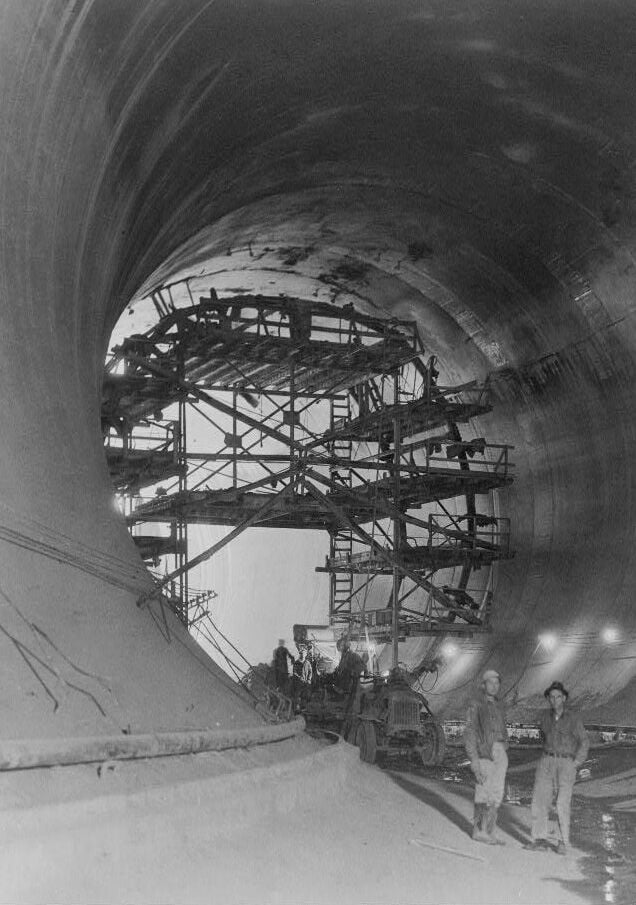
This view shows the interior of one of the tunnels through which the Colorado River will be diverted around the Hoover Dam site in Boulder City, Nev., April 18, 1932. The project is in the early stages of construction. (AP Photo)

Looking down on Hoover Dam site, the parapet is directly over the power plant site, and also part of the Nevada-Arizona highway which will traverse the dam, shown Aug. 24, 1932. Beyond this will be the greatest lake ever created by man. (AP Photo)

A lake covering 227 miles will form the 30,500,000 acre foot reservoir from Hoover Dam when completed. Elmer L. Chapman, junior reclamation service engineer, points to the hills which will be submerged after the completion of the project in Nevada, Aug. 24, 1932. The flat top lone mountain in the center of the photograph will be an island 14 feet above water. (AP Photo)

This is a downstream view of the Hoover Dam showing the immense concrete blocks rising from the bedrock of Black Canyon's floor, which will be the core of the dam, near Boulder City, Nev., Aug. 12, 1933. Concrete is being poured into the forms at the rate of about 6,000 cubic yards daily. (AP Photo)

Construction continues Jan. 9, 1932 as workers construct the retaining wall that gives support to the road leading over the top of Hoover Dam. Labor troubles were experienced during the huge engineering project on the Colorado River near Las Vegas, Nevada. (AP Photo)
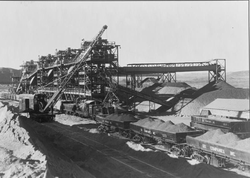
Gravel screening and washing plant in 1934. Glaha, Ben D., 1899-1970, photographer
Boulder Dam, (i.e. Hoover Dam) between Arizona and Nevada in 1933. Placing concrete in the sidewall of the Nevada spillway. A 2 cubic yard bottom-dump bucket is being handled by crane. Note the manner in which the panels are staggered
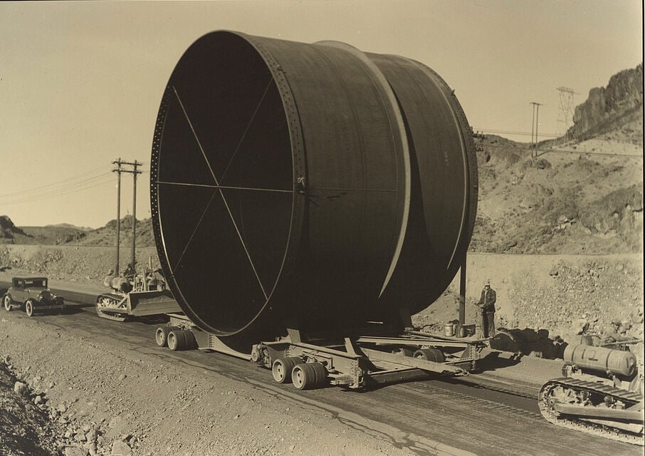
Penstock on trailer, 1934. Glaha, Ben D., 1899-1970, photographer
The Nevada intake towers at Boulder Dam in 1934. Glaha, Ben D., 1899-1970, photographer
Grouting concrete lining in 50' diameter diversion tunnel in 1934. Glaha, Ben D., 1899-1970, photographer

Construction of the Hoover Dam continues, a constant stream of large trucks dumping fifty tons of soil a minute, built an earth fill dam across the Colorado River, forcing its turbulent waters into two fifty-foot diversion tunnels on the Arizona canyon wall on Nov. 15, 1932. (AP Photo)

Inside of diversion tunnel no. 3, on the boulder dam project, showing concreting operations, July 9, 1934. The intersection of the inclined tunnel from the intake tower (above) with the present diversion which is being plugged. These tunnels will carry the 30-foot diameter steel penstocks for the power system. Photo by bureau of reclamation. (AP Photo)

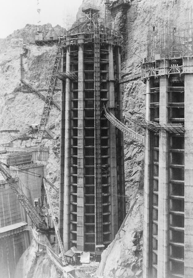
This is an aerial view of one of the four intake towers of the Hoover Dam, Aug. 9, 1934. The towers, two on each side of the canyon upstream from the dam, will measure at 380 feet high. (AP Photo)

The Boulder Dam, Black Canyon of Colorado River, is nearing completion, this view showing 500 of its projected 730 feet above the canyon floor, Aug. 28, 1934. The federal reclamation service, directing the construction, says the dam, now 80 per center completed will be finished next April, a full year ahead of schedule. (AP Photo)

A view of the huge Boulder Dam operation from a high point on the Nevada rim of the Black Canyon, shown Sept. 11, 1934. The immensity of the project can be seen from this picture. (AP Photo)

Hoover Dam takes shape from the concrete columns in which it was poured (shot from cableway control tower downstream on Nevada rim, so looking upstream) in 1934.

The rarely-seen upstream face of Hoover Dam, May 1935

This is a view of the Hoover Dam from upstream as construction continues near Boulder City, Nev., Feb. 1, 1935. The crack in the upper center of the dam is a space left open for cooling and settling of the concrete and will be filled as work progresses. (AP Photo)

This aerial view shows a crest of the Hoover Dam, aka Boulder Dam, showing the highway leading across it on July 16, 1935. The road, soon to be opened to the public, will provide an easy route between Las Vegas, Nev., and Kingman, Arizona. The intake towers jut up on the other side of the dam in Boulder City, Nevada. (AP Photo)

Night view of Boulder Dam and Mead Lake taken from a plane United airlines-western air express shows the roadway over the dam top illuminated and the candles atop the intake towers casting their reflections on the water, Sept.22, 1936 in Boulder City, Nevada. (AP Photo)

Behind boulder dam, in the black canyon of the Colorado River, is the largest man-made lake in the world shown, June 11, 1938. Pressing against the barrier of concrete and steel are 20,000,000 acre-feet of water which, translated into gallons, is enough to provide 51,100 gallons for every person in the United States. This water is to be used to meet the needs of the power house at the toe of the dam, and to irrigate the thousands of acres of reclaimed desert downstream in Arizona and California. (AP Photo)

Meet the Champs. These six 82,500 kva generators in the Nevada wing of the power house at Boulder Dam are the biggest in the word, Feb.7, 1939 . Power produced at the dam by these generators and one in the Arizona wing, amounts to 130,000,000 kilowatt hours of energy each month which sells for ?290,000. The Bureau of Reclamation which built and operates the dam, received $3,297,289 in two years. Production at this time is approximately one-third of the ultimate capacity. (AP Photo)

Aerial view of Hoover (Boulder) Dam on the Colorado River, Dec. 11, 1948. (AP Photo)

This is Main Street in Boulder City, Nevada, Aug. 24, 1932, the model construction housing center for the workers on the huge Hoover Dam project. This city was constructed at a cost of $2,000,000. (AP Photo)

A three million pound gate of tunnel no. 4, shown above at left, was ready to close, Feb. 1, 1935, stopping flow of the Colorado River at the Boulder Dam, thus starting filling of a huge reservoir. The above photo taken just before the gate stated closing shows a coffer dam built across the entrance of tunnel no. 3, which has been diverting the river through the canyon walls and around the dam on the Arizona side. (AP Photo)

Spectators watch from bridge over spillway as Boulder Dam overflows for first time, August 6, 1941, and pours 15,000 cubic feet per minute from record level of Lake Mead into Colorado River behind the dam. Spillway leads into tunnel 50 feet in diameter and then 2200 feet to river level below where water bursts out in great jet. At Dam, Lake Mead had reached level of 590 feet and contained more than 10,000,000,000,000 of water. (AP Photo)

The mighty man-made falls of the Colorado River with the six outlets wide open in a night display. Since the start of generation of power here the dam has been a night-time Mecca for tourists in Los Angeles, Sept. 22, 1936. The transmission of power to Los Angeles will be started on October 9. (AP Photo)

The 115,000-vollite generator in the world?s biggest power plant, here at Boulder City, Sept. 29, 1936, where all is in readiness to start electricity over the world?s longest power transmission line ? 365 miles to Los Angeles. (AP Photo)

This magnificent man-made scenic favorite is Hoover Dam by night, May 11, 1953, one of this century?s outstanding triumphs of engineering and construction. At its foot is Lake Mead, the world?s largest man-made body of water on Popular with anglers and fans of boating, Lake Mead is fast becoming a favorite vacation playground. Gateway to the Hoover Dam ? Lake Mead recreational area is fabulous Las Vegas, Nevada on the main line of Union Pacific Railroad. AP Photo)

The mighty Hoover Dam impresses a young Swiss couple making their first tour of United States on their scooter, April 9, 1954 in Nevada. Natives of Zurich, Fred and Beatrice Troller were veteran scooter travelers in Europe before coming here. (AP Photo)

Boulder Dam?s mighty water intake towers, rising 395 feet into the air, are in picture of the gigantic power project shown, April 14, 1938. Through these towers flows the water which operates the huge generators in the powerhouse below the 727-foot dam. On the shores of the 110-mile long lake impounded, the government has established the boulder dam recreational area. Luxurious accommodations are available at Boulder City. New a regular airline stop. (AP Photo)

English: Tourists gather around one of the generators in the Nevada wing of the powerhouse of Boulder Dam (later Hoover Dam) to hear its operation explained.

Hoover Dam at Dusk, Sept. 20, 1950. (AP Photo)

This July 18, 2014 photo shows generators inside the Hoover Dam, located on the Colorado River, on the border between Arizona and Nevada. It's considered one of America's great civil engineering wonders. Located about a half-hour from Las Vegas, it's a top destination for visitors to the region. (AP Photo/John Marshall)

In this July 28, 2014 photo, lightning strikes over Lake Mead near Hoover Dam at the Lake Mead National Recreation Area in Arizona. On the left are the Arizona intake towers of Hoover Dam. The bathtub ring of light minerals shows the high water mark of the reservoir which has shrunk to its lowest point since it was first filled in the 1930s. (AP Photo/John Locher)

Low water levels in the Lake Mead reservoir and at the Hoover Dam show a "bath tub ring" on October 14, 2015. Water in the lake has continued to drop. (Irfan Khan/Los Angeles Times/TNS)

A boater gets an up-close view the "bathtub ring" that is visible at low water levels and is the result of the deposition of minerals on previously submerged surfaces while touring the front of Hoover Dam, which sits on the border of Nevada and Arizona, at Lake Mead, Nevada, June 28, 2021.

The intake towers that feed Hoover Dam’s power generators are almost fully exposed as the Lake Mead water level continues to decline in June, 2022.

