


The U.S. Bureau of Reclamation is considering altering its monthly Colorado River forecasting methods in the face of criticism from experts inside and outside the agency that predictions have been too optimistic.
Changing forecast methods could have major ramifications in how the bureau manages the river, water experts say. Larger cutbacks in water deliveries to Arizona, Nevada and California could possibly be triggered, for example.
The agency will consider starting to base its forecasts on the past 20 years of flows into Lake Powell, compared to the 30 years it uses now, a bureau official told the Arizona Daily Star.
That’s what several outside scientists have urged the bureau to do, on the grounds that the shorter time period will screen out a lengthy wet period from the 1990s when runoff into the river was much greater than it’s been since 2000.
Such a change would almost certainly make the forecasts more pessimistic than now. That’s because the years since 2000 have not only been extremely dry, some scientists have found them to be the driest in the Southwest for the past 1,200 years. Average annual river flows have dropped from about 15 million acre-feet over the 20th century to barely 12 million since 2000.
The bureau’s expressed willingness to consider changes comes after one of its engineers, James Prairie, aired significant reservations about current forecasting methods at a public water conference held in Denver during the summer of 2022.
His concerns closely matched those raised for several years by outside scientists, most prominent among them Brad Udall. Udall, a Colorado State University water researcher, has been at the forefront since the early 2000s in warning about the risks to the Colorado River from climate change. He and several other outside scientists released a report about a year ago that criticized the accuracy of bureau forecasts.
Predicting availability of water
At issue are what’s called “24-month studies” that the bureau releases every month. The studies use computer models to forecast reservoir water levels for each of the upcoming 24 months. These monthly forecasts are well publicized and regularly discussed in the media by a wide range of water experts, including scholars, government water officials, activists, and engineers and hydrologists in the private sector.
A change to a 20-year forecasting model could have major implications for how the bureau plans its annual releases from Lake Powell to Lake Mead and how it determines the levels of future shortages in river water deliveries from Mead to Lower Basin states, said another outside critic, Eric Kuhn. He’s an author and researcher and retired general manager of the Colorado River Water Conservation District in Glenwood Springs, Colorado.
For one, it could affect the scale of cutbacks that the bureau makes annually from Lake Mead into the river’s Lower Basin of Arizona, Nevada and California. That’s because the bureau bases the amount of cutbacks, if any, it will make for the following year on what its monthly forecast predicts in August will be the most likely water level at Lake Mead by the end of the current year.
It could also affect how much water the bureau releases each year from Lake Powell to Mead — an amount also crucial for river water availability for Arizona, California and Nevada, Kuhn said.
“These forecasts are the best eyes we have on the future,” Udall said. “If they are grossly off, as they have been for many years, we will not make the best possible decisions” about managing the river.
The biggest change that will occur if the method changes will be in the bureau’s prediction of the lowest likely river flows — officially called “minimum probable” flows — expected over an upcoming year or longer, Udall said.
“Recent minimum probable forecasts have utterly downplayed our risk, as we have unfortunately found out recently,” when the bureau suddenly announced last June that drastic cuts need to be made by 2023 in river basin water use, Udall said.
Information ‘may be biased’
The bureau’s Prairie raised similar concerns at a public conference in August 2022, sponsored by the advocacy group Colorado Water Congress.
“I do not have a lot of confidence” in federal forecasts of reservoir levels looking about a year ahead, Prairie said. He cited what he said are biases that are built into the forecast methods because of their reliance on temperatures and precipitation from the 1990s.
“I’m going to want to tend to skew that down,” Prairie said.
Prairie is chief of the bureau’s Colorado Basin Research and Modeling Group and has been a hydrologic engineer for the agency since 2000. He has extensive experience directing and coordinating research, development and modeling projects. He leads applied research in a wide range of topics, including long-term water resource planning and climate variability.
“As you look at this, I would not walk away thinking this is exactly where we are going to end up,” Prairie said at the conference, referring to the bureau’s forecast for the most likely amount of flows into Powell in 2023. “I would likely lean toward these lower flows, and consider that as you’re thinking about how to protect the system more.”
He told the gathering that when he works with “folks,” he will tell them that the information they are looking at from the bureau “may be biased” because of the agency’s use of 30 years of data.
“That 30-year period is a standard of NOAA (the National Oceanic and Atmospheric Administration). That’s a standard view of climate. The way they look at the concept of climate, that idea is not something that’s going to change quickly,” Prairie said. “It’s something we’ve been talking about, but it is embedded at the international level.
“That’s one reason it is going to be hard for us to move away from those consistent methods, but it’s something to think about when you look at the results,” Prairie said.
A ‘wet bias’
The bureau declined to comment on Prairie’s remarks. But in an email to the Star, a Reclamation official said the 30-year period traditionally used for forecasting could be trimmed to 20 years sometime before authorities approve new, broader guidelines for operating the river’s reservoirs after existing guidelines expire in 2026.
The official acknowledged the current forecasting system has a “wet bias,” but added that there would be tradeoffs if the forecasts were to reflect 20 years of flows instead of 30.
The official noted the Colorado River Basin “has been seeing an increased temperature trend in the past 30 years. We also see the observed record observes a wetter period from 1990-1999 than we have experienced during the current drought beginning in 2000.
As water in one of the nation's largest reservoirs recedes, geologic features hidden for nearly 50 years are revealed in Glen Canyon National Recreation Area in Northern Arizona. Video courtesy of Glen Canyon Institute, 2022
“Given the warming trend, we believe excluding the early wet years (1990-1999) could reduce the wet bias we are seeing in the recent forecasts,” said the official, who declined to be quoted by name.
“Spread represents the range of forecast — if it’s too tight, you could miss the observation (too high or below it),” said the official, in explaining tradeoffs from switching forecasting methods. “If it’s too wide, then you don’t capture the specific forecast. Trying to balance the trend between accuracy and spread” is the need.
“Using a shorter forecast period may result in an overall drier forecast but may also result in narrower range of runoff possibilities (e.g., any future wet periods may not be forecast accurately),” Ashley Nielson, a senior hydrologist for the federal Colorado Basin River Forecast Center, has told the Star. “To account for the large amount of hydroclimactic variability within the Colorado River Basin, we cannot only rely on dry scenarios.”
The possibility that forecasting methods could be tightened comes a little more than a year since the bureau last altered them. Until then, it relied on river flows from 1981 to 2010, but has since changed that period to 1991 to 2020. The change being considered would make that 2000 to 2020.
Critics say a 30-year period isn’t workable in a rapidly changing climate.
“When I teach classes, you always teach that using more data is better,” said Professor Jack Schmidt, a longtime Utah State University water researcher. “Unfortunately, in a changing, warming world, having a long averaging period isn’t necessarily better.”
Udall, Kuhn and Schmidt collaborated with others on a February 2022 study by Utah State’s Center for Colorado River Studies. It concluded the Bureau of Reclamation’s 24-month studies issued from 2010 through 2021 made projections for the most likely flows that in some cases were 7 million acre-feet a year more than what actually flowed into Powell.
It’s widely accepted among many scientists that using 30 years isn’t appropriate in an era of climate change, Udall said, “but the problem is that there is no new standard. It leaves everybody searching for a consensus (forecasting) process that doesn’t exist.”
Photos: The receding waters of Lake Powell, Glen Canyon National Recreation Area

Tom Wright hikes past the beached marker for Willow Canyon where it joins with the Escalante River, Glen Canyon National Recreation Area, Utah.

A big horn sheep stands with the moon as a backdrop, looking over Fiftymile Creek, Glen Canyon National Recreation Area, Utah.
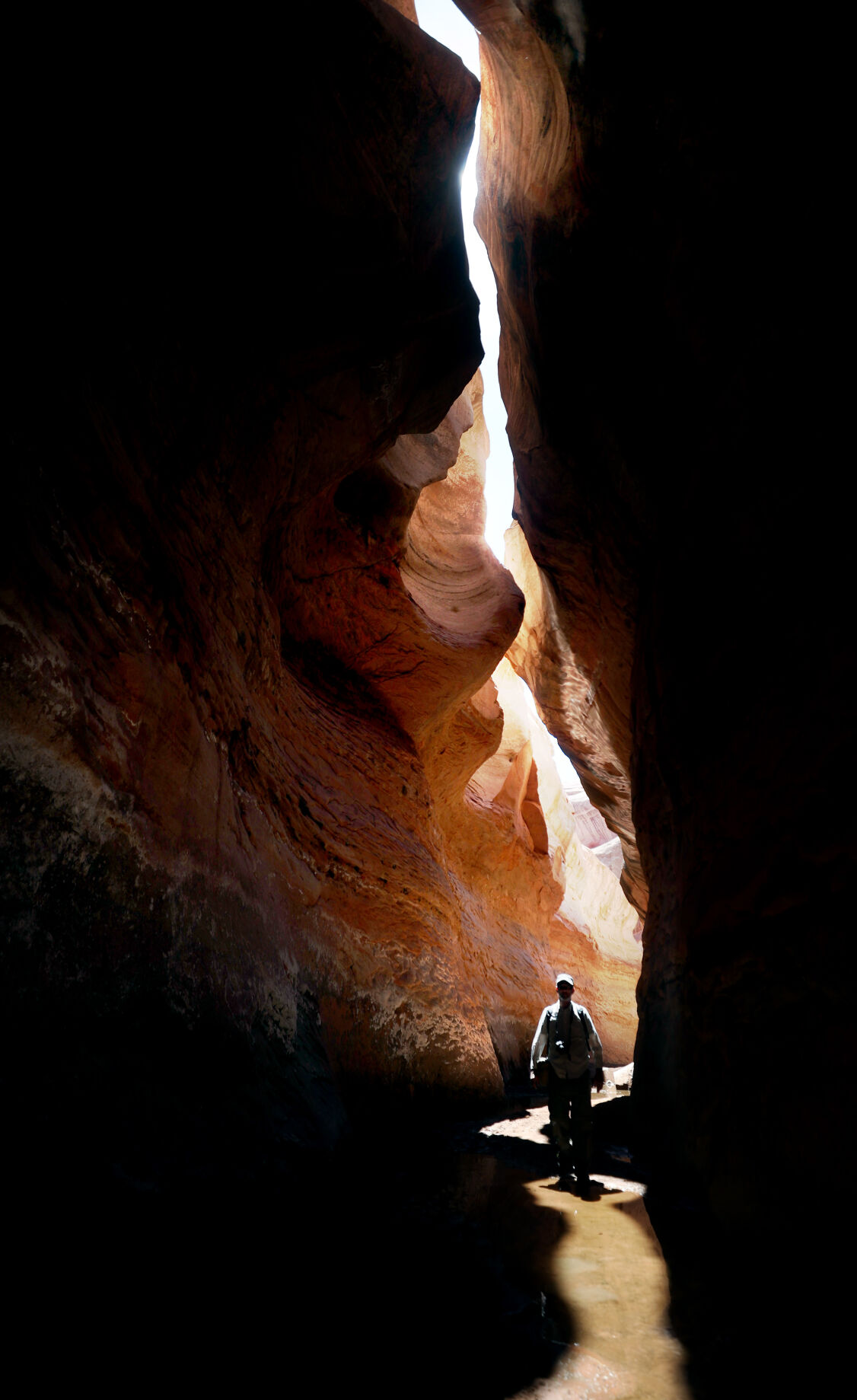
Tom Wright walks through the shaft of light peeking through the narrow openings of the formation called the Subway in Fiftymile Creek, accessible since the waters of Lake Powell have fallen dramatically.

A narrow sliver of sky is visible overhead through the narrow opening of the formation called the Subway, Fiftymile Creek, accessible since the waters of Lake Powell have fallen dramatically.

The dark streaking, called Desert Varnish, is from the seepage of oxidation in the rocks, and is beginning to erase the "bathtub ring", the lighter colored marks left by the waters of Lake Powell on canyon walls, Fiftymile Creek, Glen Canyon National Recreation Area, Utah.

The remains of a small boat, underwater for years, reemerges due to receding water levels of Lake Powell in the Glen Canyon National Recreation Area, Utah.
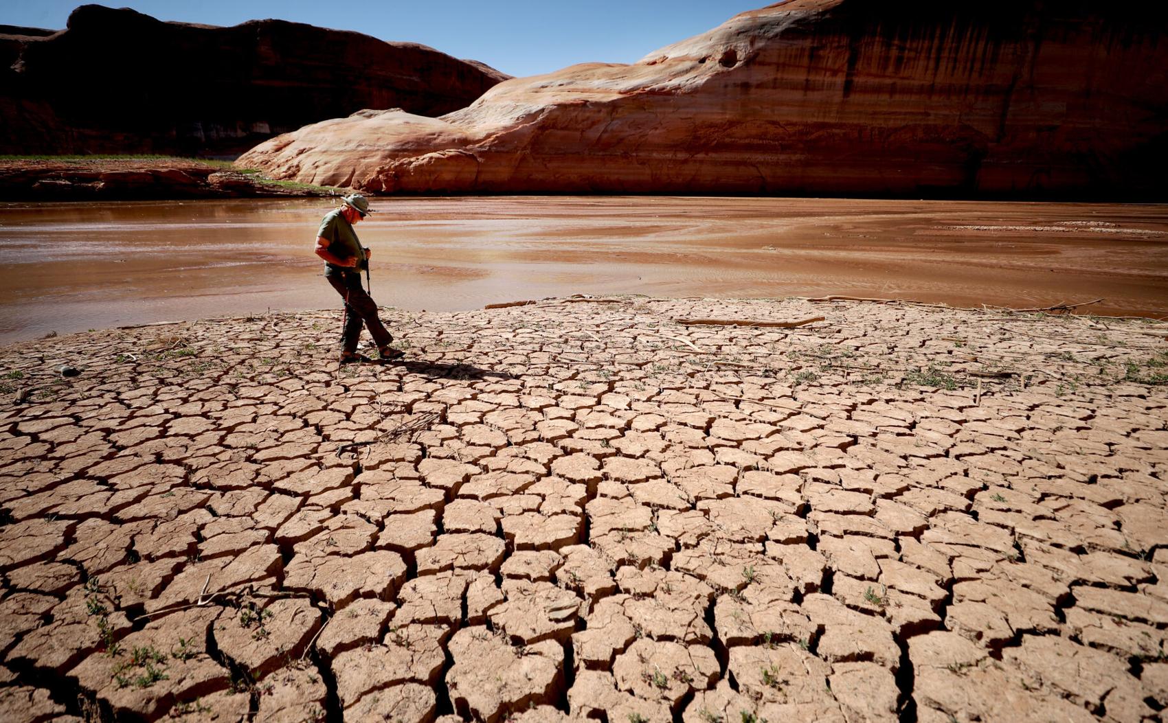
Frank Colver makes his way over the dried and cracking silt left where the Escalante River joins Lake Powell, Glen Canyon National Recreation Area, Utah. The receding water of the lake has the river cutting through the decades of accumulated silt to form a delta where it meets the lake.

A warning buoy sits high and dry far from the end of the closed public boat ramp at Bullfrog Bay, Glen Canyon National Recreation Area.

A line of tires that were once breakwaters at Bullfrog Bay Marina are now stranded on the rocky landscape high above the current water levels at the Glen Canyon National Recreation Area, Utah.
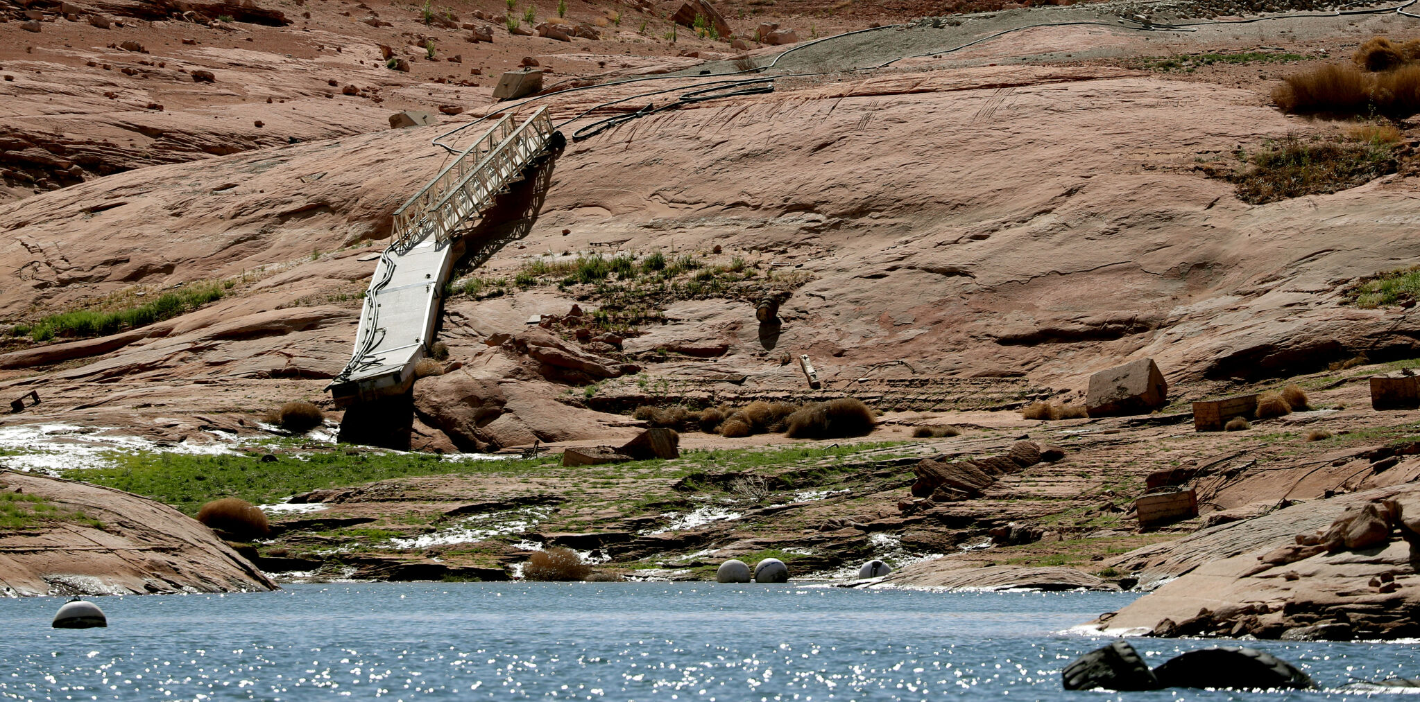
A pedestrian ramp lies well above the water levels at Bullfrog Bay in the Glen Canyon National Recreation Area, Utah.

A stranded wakeless zone buoy sits on the cracking silt outside the new shores of the Bullfrog Bay Marina, Glen Canyon National Recreation Area, Utah.

The end of the ferry ramp ends well short of the new water levels of Bullfrog Bay on the Glen Canyon National Recreation Area, Utah.

An early riser watches the sun come over the low waters of Bullfrog Bay Marina, Glen Canyon National Recreation Aria, Utah. The lighter colored areas on the canyon wall mark previous water levels.

A group of river rafters drift west on the current of the San Juan River outside Mexican Hat. The San Juan feeds Lake Powell.

The tops of a few cottonwood trees begin to poke out of shrunken water of Lake Powell, Fiftymile Creek, Glen Canyon National Recreation Area, Utah.

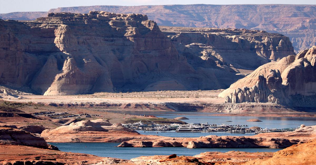
The remaining large water craft and house boats are crowded together in one of the last areas of water deep enough to support them at Wahweap Mariana, Glen Canyon National Recreation Area, Page, Ariz.

The waters of Lake Powell are twenty to thirty feet below the end of the public boat ramp at Wahweap Mariana, Glen Canyon National Recreation Area, Page, Ariz. Personal non-powered craft still use the ramp to unload, but must be carried up and down the banks to reach the water.

A view north from the Wahweap Marina Overlook show the shrunken waters around the marina in Glen Canyon National Recreation Area, Page, Ariz.

The underside of Gregory Natural Bridge, passable for the first time in almost 50 years, over the Fiftymile Creek, Glen Canyon National Recreation Area, Utah.

The moon rises over Gregory Natural Bridge, passable for the first time in almost 50 years, over the Fiftymile Creek, Glen Canyon National Recreation Area, Utah.

The exposed penstocks (intakes to the power turbines) on Glen Canyon Dam in the Glen Canyon National Recreation Area, Page, Ariz. The water level is at its lowest since 1967, when the dam was still being initially filled.

A group of sightseers get a look at the Glen Canyon Dam during a boat tour of Lake Powell, Glen Canyon National Recreation Area, Page, Ariz.

A small fishing boat ties up on the breakwater just outside the intakes for the Glen Canyon Dam, Glen Canyon National Recreation Area, Page, Ariz.. The penstocks (water intakes to the power turbines) are revealed for the first time since 1967 when the Lake Powell was being filled.

Swimmers and bathers use the jagged shores of the newly exposed banks of Lake Powell just above the Glen Canyon Dam, Glen Canyon National Recreation Area, Page, Ariz.

The Glen Canyon Bridge lies in front of electrical towers with feeder lines rising from the hydroelectric plant in the Glen Canyon Dam, Page, Ariz.

Glen Canyon Dam from Glen Canyon Bridge, Page, Ariz.

Small power boats on the Colorado River head upstream just below the Glen Canyon Dam, Page, Ariz.

Wade Quilter walks through the remains of cottonwood and Russian olive trees washed down and joined with silt to form a natural dam where Willow Canyon joins with the Escalante River, Glen Canyon National Recreation Area, Utah,

The remains of a big mouth bass lay in the silt just above where the Escalante River joins Lake Powell, Glen Canyon National Recreation Area, Utah.

The formation known as The Cathedral in the Desert on Clear Creek, Glen Canyon National Recreation Area, Utah. The re-emergence of the formation is drawing sightseers after being submerged for some 50 years.

Tom Wright feels the water oozing from the rocks in the formation known as Cathedral in the Desert on Clear Creek, Glen Canyon National Recreation Area, Utah. The re-emergence of the formation is drawing sightseers after being submerged for some 50 years.

Frank Colver takes a quiet moment and plays a handmade flute near the waterfall in the formation known as Cathedral in the Desert on Clear Creek, Glen Canyon National Recreation Area, Utah. The re-emergence of the formation is drawing sightseers after being submerged for some 50 years.

Jake Quilter walks down the newly cut banks of Clear Creek just outside Cathedral in the Desert, Glen Canyon National Recreation Area Utah. The sand is silt left behind by the receding waters of Lake Powell.

The tops of cottonwood trees that used to be under a hundred feet of water in Lake Powell are visible again in Clear Creek, Glen Canyon National Recreation Area, Utah. The deep water preserved the remains of the trees.

Boaters have to zig-zag through the rocks emerging due to receding waters of Lake Powell, Glen Canyon National Recreation Area, Page, Ariz.

Several images combined for a panoramic view of the Colorado River where it runs through the what once was Hite Marina in the Glen Canyon National Recreation Area, Utah.

A couple of sightseers take in the view from Hite Overlook over the Colorado River and the closed Hite Marina, Glen Canyon National Recreation Area, Utah.

Lone Rock, jutting out of the dry bed, would usually be surrounded by Lake Powell but is now well clear of the water, Glen Canyon National Recreation Area, Utah.

Tires that used to hold the lines well below the surface of Lake Powell are suspended over the water at Antelope Point Marina, Ariz.

Sightseers twenty or thirty feet above get photos of the low water levels of Lake Powell from the public boat ramp at Antelope Point Marina, Ariz.

The pedestrian access ramp ends abruptly twenty feet over the new Lake Powell surface at Antelope Point Marina, Ariz.

The entrance to the pedestrian access ramp of the Antelope Point Marina is taped off after being cutoff from the docks due to receding waters of Lake Powell.

