

Hurricane Ian barreled ashore with winds of up to 150 mph (240 kph) on Florida’s southwest coast on Sept. 28, 2022.
The storm’s powerful winds and torrential rains reduced entire communities to rubble, killing more than 120 people, including many who drowned in floodwaters resulting from the nearly 18-foot (5.5-meter) storm surge. Bridges connecting Sanibel, Captiva and other barrier islands with the mainland flooded and crumbled, isolating those areas.
Estimates of the economic toll are still preliminary. But as a historian who studies South Florida’s cities and environment, I’m certain that the havoc Ian wreaked will make it among the worst storms on record, along with Harvey and Maria in 2017 and Katrina in 2005.
And based on how Florida has responded to similar devastation in the past, I highly doubt that Ian will do much to slow the pace of the state’s rapid population growth in the near future.
 Miami's streets were bustling and crowded by 1926. Bettmann/Getty Images
Snowbirds are changing their routes
Over 22 million people currently live in Florida.
That’s about 37% more than the 16 million who resided in the state in 2000. And demographers project that the population will continue increasing, to about 25 million within the next decade.
Florida consistently ranks as the top destination for Americans who relocate to another state.
But many Florida residents spend only the winter months there, returning when the climate warms up back home. In the weeks that followed the storm, analysts were predicting that most of these annual short-term residents – called snowbirds – will not forgo their annual voyage. Instead, many say they’ll simply shift their migratory course and land somewhere else in Florida.
South Florida real estate agents are bracing for stronger-than-usual demand for seasonal rentals in Dade and Broward counties on Florida’s southeast coast, which escaped Ian’s wrath. The extra interest is leading to further spikes in the already overheated real estate markets in places like Miami and Fort Lauderdale.
Today’s new and part-time Floridians are drawn by the same factors that have lured settlers and snowbirds for a century: warm weather and waterfront views, along with lower taxes and fewer regulations than in other parts of the country.
Draining the swampland
Early developers didn’t let inhospitable environments deter them. In the decades after the Civil War, they transformed the peninsular state’s mosquito-ridden, alligator-occupied swampland into hotels, homesteads and farmland.
Florida promoters lured tourists and settlers alike with promises of wealth, land and leisure, whether their sales pitches had to do with citrus and sugar, or sun and sand. Engineers used modern technology to accomplish the large-scale transformation and make way for unprecedented land speculation and development.
Everglades drainage began in earnest in the 1880s when a wealthy Philadelphian named Hamilton Disston created the Okeechobee Land Co. to develop a system of canals that would facilitate “land reclamation.”
Disston purchased over 4 million acres the state had designated as uninhabitable swampland in exchange for US$1 million and his promise to transform it. In 1881, The New York Times called this “the largest purchase of land ever made by a single person in the world.”
His gambit sparked Florida’s first real estate boom.
Disston sent brochures around the country, and to people as far away as Scotland, Denmark, Germany and Italy, that touted Florida’s “inexhaustibly rich lands” and an “equitable and lovely climate where merely to live is a pleasure, a luxury heretofore accessible only to millionaires,” according to Frank B. Sessa’s 1950 history of greater Miami.
Disston and others began selling reclaimed land to railroads, farming interests and land developers. By the early 20th century, inland drainage was giving rise to the sugar, citrus and winter vegetable industries.
The drainage made it possible for the railroad magnates Henry Flagler and Henry Plant to extend their railroads to southeast and southwest Florida, respectively. Train travel greatly expanded opportunities for tourists and new residents by the late 19th century.
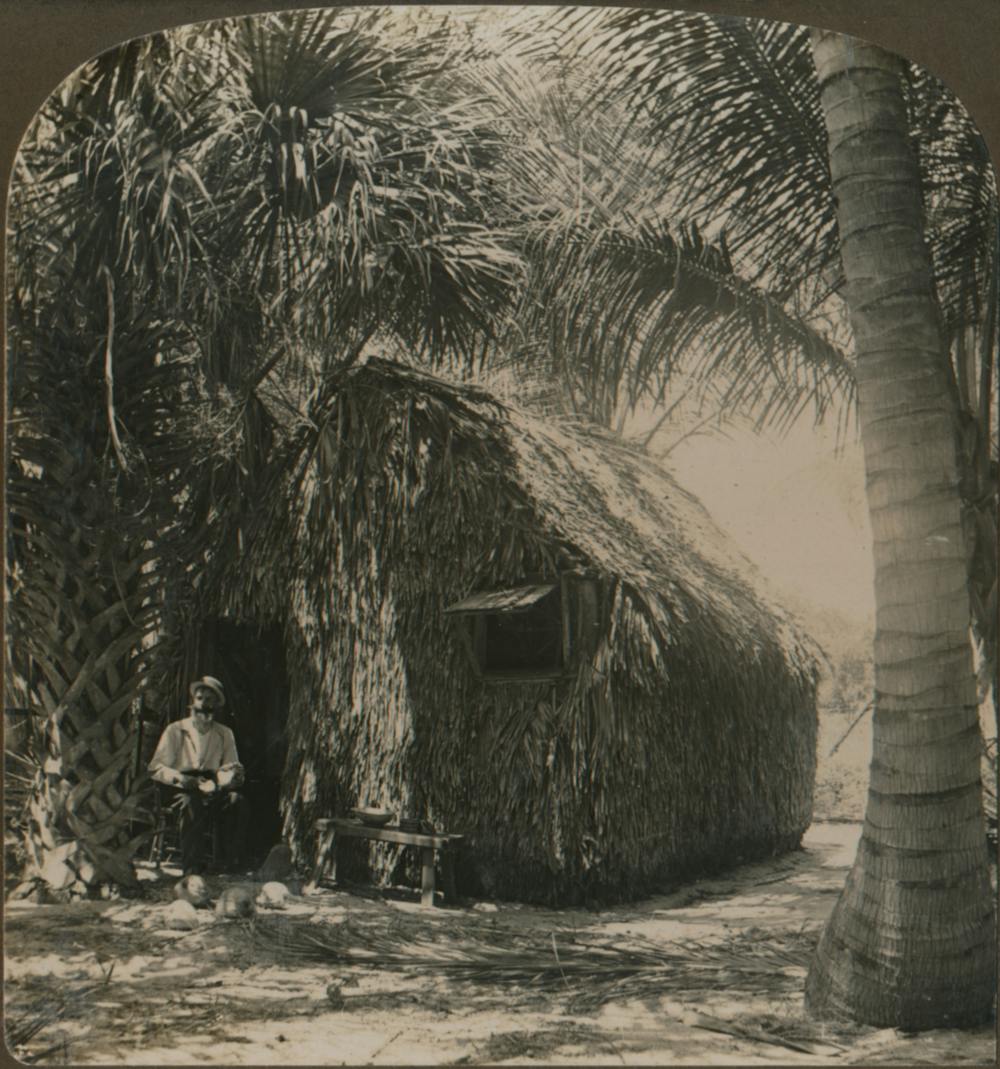 This tiny thatched Florida house, photographed in the early 1900s, looks nothing like housing there today. Hulton Archive/Getty Images
Stormy weather from the start
Attempts to control water on the ground, however, couldn’t curtail weather-related hazards. In 1926, a hurricane slammed into Miami, leaving more than 390 people dead and causing property damage of more than $76 million.
A Western Union telegram from Jessie Wirth Munroe, a survivor, read like a text from someone who had endured Hurricane Ian: “We are safe. Water front completely destroyed.”
Subsequent storms wrought greater devastation.
A 1928 hurricane killed over 2,500 people just south of Lake Okeechobee, most of them Black farmworkers laboring in the new agricultural town of Belle Glade, which was washed away.
In 1935, a Labor Day storm hit the Civilian Conservation Corps camps in the Florida Keys, where workers, many of them World War I veterans, were building a highway that would link mainland Florida to Key West.
“Clinging to beds, using mattresses as overhead cover, the people of the Keys had watched large rocks roll about like pebbles, buildings crumble like houses of cards, water lift up houses and carry them off,” wrote Helen Muir, a journalist who moved to Miami in 1934 and chronicled the city’s growth. “The hurricane moved in like a giant mowing machine and leveled everything.”
No stopping the newcomers
Yet people kept coming, especially after World War II and the advent of widespread air conditioning.
Many of the close to 3 million people who arrived between 1940 and 1960 were veterans who had trained in South Florida during World War II.
In addition, millions more immigrated from the Caribbean and Latin America as transportation become easier and cheaper.
In particular, people fleeing political persecution and economic instability in places such as Cuba, Haiti and, more recently, Venezuela and Central America have settled in Florida.
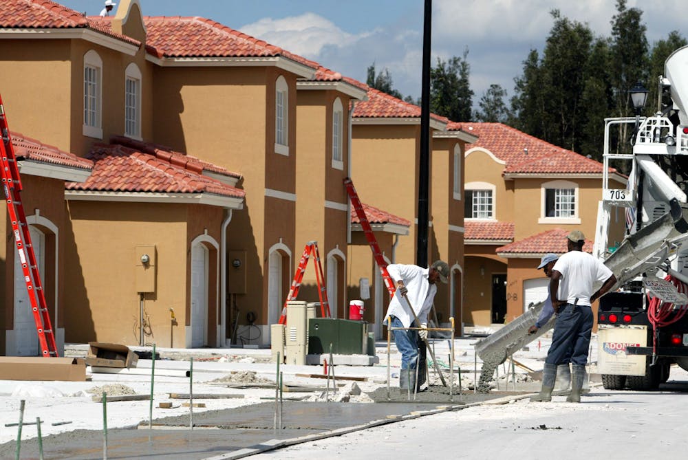 Housing construction was booming in Miami in 2002, a few years after Andrew destroyed many homes. Joe Raedle/Getty Images
Rebuilding and rebuilding
Though each storm seemed to threaten the population boom, the new arrivals tended to stick around. Civic boosters, business leaders and policymakers have invariably promised to rebuild.
After Hurricane Andrew, a Category 5 storm, slammed into South Florida in 1992, the state imposed a stronger and more uniform building code. The authorities invested in additional storm preparedness efforts after the spate of hurricanes hit the state in 2004.
Could these patterns change after Hurricane Ian?
Windstorm insurance premiums were climbing beyond the reach of many homeowners before it hit. Analysts predict that premiums will continue to rise, making it harder for residents to afford to remain in Florida and even more challenging for new homebuyers to secure policies.
It remains to be seen if the pro-growth mentality and belief in technological innovation that have shaped Florida’s history can forestall the challenges of climate change and the increasingly severe storms it brings about in the decades ahead.
___
Robin Faith Bachin receives funding from JPMorgan Chase and Co., Miami-Dade County Department of Public Housing and Community Development.
___
Undeterred by climate change, US homeowners are moving to climate-vulnerable areas
A look at migration rates to climate-vulnerable areas
Updated
Some of the most highly prized real estate in the U.S. exists in areas considered high risk for wildfires, flooding, or drought. Despite this present and growing danger, many Americans are still moving to climate-vulnerable regions.
This may be because some people are willing to take the risk if it means living in their dream home—an attempt to defy nature for one’s own hubris. To better educate prospective homebuyers, real estate brokerage site Redfin now provides a climate risk assessment for every property which includes flood, drought, heat, storm, and fire risk data at a glance. Even with the power of this information, homes with high fire risk are selling for $120,000 more than low-risk properties, per Refin’s June 2022 report.
As housing demand increases, so, too, do the impacts of climate change. Homebuilders and homebuyers are expanding into vulnerable regions called the wildland urban interface—the area where real estate abuts or intermixes with natural land like forests or grassland. A forest without homes in or along the edge is just a forest. But when developers introduce commercial or residential properties, it becomes a wildland-urban interface, or WUI. The U.S.’s WUI, in terms of acreage, grew by 33% over 20 years. Nearly all of that growth resulted from new housing—roughly 14 million homes—being built in or along natural land.
Housing along the U.S. coastline, especially the East Coast, is also at risk. Within the next 30 years, sea levels are projected to rise by up to a foot; within 80 years, up to 2 feet. A matter of inches within the scope of an entire coastline seems unsubstantial, but this increase will bring more intense flooding and storm surges. According to the National Oceanic and Atmospheric Administration, moderate flooding could happen 10 times as often in 2050 as it does today.
Mitigation efforts like governmental buyouts of homes in flood-prone regions can be one solution to this problem. It would cost the government $180 billion to purchase 1 million flood-prone homes across the country, according to a 2019 National Institute of Building Sciences report. Over 100 years, that would lead to a cost savings of more than $1 trillion that would have been paid out in flood insurance and disaster programs, which are federally subsidized.
Moving, either to a climate-vulnerable location despite the risks, or away from it for safety, is a form of privilege. A 2021 study published by the Environmental Protection Agency found coastal flooding, extreme temperatures, and poor air quality disproportionately affect minority and low income populations. And for populations already living in safe regions, climate gentrification—when affluent homebuyers move from climate vulnerable areas into new places, driving up home prices and changing the culture—is an indirect threat to their stability.
Experts predict that for much of the southern and southwestern U.S., a push north to more temperate climates is an eventual certainty for those with the necessary means, as climate change makes swaths of the country inhospitable and drives severe economic losses.
To better understand the climate-related threats Americans face, Stacker looked at population change due to migration in counties with the greatest and lowest climate risk between 2015-2019, citing Federal Emergency Management Agency’s National Risk Index data and U.S. Census Bureau net migration data. We focused on 2015-2019 because the impacts of the pandemic meant abnormal net migration rates across much of the country.
You may also like: Best places to retire in America![]()
Coastal flooding
Updated
Future flood risks to coastal regions under warming climate conditions have been well documented. And still, much of the East Coast has developed new housing in high-risk flood regions faster than in safer areas. In New Jersey, the worst offender of this trend, new housing development in coastal areas was three times higher than construction in inland regions.
In 2021, the Natural Resources Defense Council and the Association of State Floodplain Managers petitioned FEMA to update its rules for building in floodplains—which have not been updated in more than four decades—to avoid devastating losses for future homeowners. The petition recommended mandating that all new construction happen beyond the 100-year flood zone, updating developers’ maps to show how the floodplain will change over time, and helping current owners retrofit their homes through flexible National Flood Insurance Program funding.
River flooding
Updated
In many parts of the country, rivers are drying up due to climate-related precipitation changes and increased temperatures. Models predict that the Colorado River Basin—which extends from the Gulf of California to the Rocky Mountains and diverts water to major cities along the way—will see significant, and in some areas total, loss of critical snowpack and snowmelt runoff. In the Northeast and Midwest, heavier precipitation can lead to higher river volume and more frequent flooding.
Hurricanes
Updated
Between June 1 and November 30, the Gulf Coast states brace for the potential impacts of hurricane season. Like other climate-driven extreme weather events, hurricanes are becoming more frequent and intense. Historically, Florida has been more severely affected by hurricanes than any other state in terms of total monetary damage and emergency declarations. Between 2010 and 2019, the economic damage in Florida was more than $500 million per hurricane, totaling roughly $3.5 billion over the decade. In this same period, Florida made 14 hurricane-related disaster declarations.
According to NOAA, many coastal counties in Florida like St. Lucie will be underwater if sea levels continue to rise. Despite all this, the state’s real estate market remains one of the hottest in the country.
Heat waves
Updated
Heat waves in the U.S. are getting longer, hotter, and more frequent. Roughly 60 years ago, cities across the country averaged two heat waves per year. Today, the country averages more than six per year, and the heat wave season has extended by more than a month. Many of the regions at high risk for heat waves that saw a population decrease, as highlighted in the graphic above, were urban areas. It is difficult to isolate to what extent weather played a role in this exodus. However, scientists warn that the urban heat island effect, in which the release of heat from buildings and vehicles trapped by concrete and greenhouse gasses creates higher surface air temperatures in urban areas, will become more severe, making urban areas undesirable.
Drought
Updated
The U.S. is the driest it’s been in more than 1,500 years. The Southwest has been in the throes of a megadrought for 22 years, exacerbated by less frequent rainfall, lower soil moisture, and rising temperatures. Water stress creates ecological changes that can increase the risk for other extreme weather events like wildfires. The volume of drought-sensitive vegetation in a region, for example, can significantly affect the severity of a wildfire. In the path of a blaze, plants that are quick to dry out in the absence of moisture act like tinder.
According to a Fast Company study, places like the Sierra Nevada foothills, San Francisco Bay, San Diego, and San Antonio all have a high volume of drought-sensitive vegetation and have also seen a population increase in the WUI where that vegetation is most prevalent.
Wildfires
Updated
Wildfires in the U.S. have become more severe and more frequent due to climate change. Wildfires are four times larger and occur three times more often in the past two decades compared to the previous 20 years, according to a University of Colorado Boulder study. In addition to the problem of human ignition in the WUI, increased drought means wildfires are spreading faster and farther. Currently, 80 million properties across the country are at significant risk of fire exposure, and that number is growing. Over the next 30 years, nearly half of Americans will be living in fire-risk areas, particularly in the Mountain and West South Central regions.
Heat waves
Updated
Heat waves in the U.S. are getting longer, hotter, and more frequent. Roughly 60 years ago, cities across the country averaged two heat waves per year. Today, the country averages more than six per year, and the heat wave season has extended by more than a month. Many of the regions at high risk for heat waves that saw a population decrease, as highlighted in the graphic above, were urban areas. It is difficult to isolate to what extent weather played a role in this exodus. However, scientists warn that the urban heat island effect, in which the release of heat from buildings and vehicles trapped by concrete and greenhouse gasses creates higher surface air temperatures in urban areas, will become more severe, making urban areas undesirable.

