


NASA video explains how and when the asteroid Bennu might impact the Earth, though the chances at very slim.
CAPE CANAVERAL, Fla. (AP) — The good news is that scientists have a better handle on asteroid Bennu's whereabouts for the next 200 years. The bad news is that the space rock has a slightly greater chance of clobbering Earth than previously thought.
But don't be alarmed: Scientists reported Wednesday that the odds are still quite low that Bennu will hit us in the next century.
Keep scrolling for a gallery of 30 breathtaking images from NASA's public library
"We shouldn't be worried about it too much," said Davide Farnocchia, a scientist with NASA's Center for Near Earth Object Studies at the Jet Propulsion Laboratory in Pasadena, California, who served as the study's lead author.
While the odds of a strike have risen from 1-in-2,700 to 1-in-1,750 over the next century or two, scientists now have a much better idea of Bennu's path thanks to NASA's Osiris-Rex spacecraft, according to Farnocchia.
"So I think that overall, the situation has improved," he told reporters.
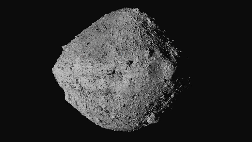
FILE - This undated image made available by NASA shows the asteroid Bennu from the OSIRIS-REx spacecraft.
The spacecraft is headed back to Earth on a long, roundabout loop after collecting samples from the large, spinning rubble pile of an asteroid, considered one of the two most hazardous known asteroids in our solar system. The samples are due here in 2023.
Before Osiris-Rex arrived at Bennu in 2018, telescopes provided solid insight into the asteroid, about one-third of a mile (one-half kilometer) in diameter. The spacecraft collected enough data over 2 1/2 years to help scientists better predict the asteroid's orbital path well into the future.
Their findings — published in the journal Icarus — should also help in charting the course of other asteroids and give Earth a better fighting chance if and when another hazardous space rock heads our way.
Before Osiris-Rex arrived on the scene, scientists put the odds of Bennu hitting Earth through the year 2200 at 1-in-2,700. Now it's 1-in-1,750 through the year 2300. The single most menacing day is Sept. 24, 2182.
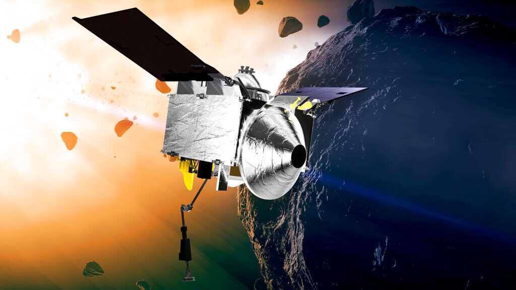
FILE - This illustration provided by NASA depicts the OSIRIS-REx spacecraft at the asteroid Bennu.
Bennu will have a close encounter with Earth in 2135 when it passes within half the distance of the moon. Earth's gravity could tweak its future path and put it on a collision course with Earth in the 2200s — less likely now based on Osiris-Rex observations.
If Bennu did slam into Earth, it wouldn't wipe out life, dinosaur-style, but rather create a crater roughly 10 to 20 times the size of the asteroid, said Lindley Johnson, NASA's planetary defense officer. The area of devastation would be much bigger: as much as 100 times the size of the crater.
If an object Bennu's size hit the Eastern Seaboard, it "would pretty much devastate things up and down the coast," he told reporters.
Scientists already are ahead of the curve with Bennu, which was discovered in 1999. Finding threatening asteroids in advance increases the chances and options for pushing them out of our way, Johnson said.
"One-hundred years from now, who knows what the technology is going to be?" he said.
In November, NASA plans to launch a mission to knock an asteroid off-course by hitting it. The experimental target will be the moonlet of a bigger space rock.
***
PHOTO GALLERY
30 breathtaking images from NASA's public library
30 breathtaking images from NASA's public library
Updated
The National Aeronautics and Space Administration (NASA) in 2017 opened the digital doors to its image and video library website, allowing the public to access more than 140,000 images, videos, and audio files. The collection provides unprecedented views of space. Stacker reviewed the collection to select 30 of the most breathtaking images, curated here with further information about the captured scenes.
NASA officially began operations on Oct. 1, 1958, as the primary organization for U.S. civil aerospace research and development. In just 11 years, NASA in 1969 landed the first human on the moon. In the 1970s, the focus shifted to developing a space station. Skylab was launched, unmanned, in May 1973. Three crewed missions followed during the next seven months to repair the station and conduct experiments. The first international space station partnership was the Apollo-Soyuz Test Project in 1975, which brought American and Soviet crews together.
The space shuttle program became fully realized in April 1981 with the manned launch of the Columbia. In 135 missions flown with five shuttles, there were two catastrophic accidents—Challenger and Columbia. Discovery delivered the Hubble Space Telescope into orbit. The 30-year shuttle program was significant in setting the foundation for future Earth-to-orbit transportation and sustained space stays.
Shuttle technology led to the construction of the International Space Station, the largest structure humans have put into space. Two hundred thirty people from 18 countries have lived there since 2000, conducting experiments and documenting life in space.
Achievements like these make up the substance of the NASA Image and Video Library, featuring the best of the agency’s work in aeronautics, astrophysics, Earth science, human spaceflight, and more. Keep reading to see 30 of these stunning images.
You may also like: Space discoveries that will blow your mind
The moon from Apollo 11
Updated
On July 20, 1969, Apollo 11 astronauts Neil Armstrong and Edwin Aldrin made history by landing on the moon while pilot Michael Collins remained in lunar orbit. While returning home on July 21, the crew captured this picture of the full moon. Earth’s only natural satellite, it circles us from an average distance of 238,900 miles away.
Earth from the International Space Station
Updated
An astronaut aboard the International Space Station shot a picture of Earth from 250 miles over Australia. Airglow—the orange hue—comprises diffuse bands of light created by atoms colliding in the atmosphere near the interface of Earth and space. Studying airglow is helping scientists to understand the connections between Earth weather and space weather.
Hurricanes on Earth
Updated
Several large hurricanes were brewing in the Atlantic Ocean in September 2017. By assembling several images taken in one day by the Visible Infrared Imaging Radiometer Suite, NASA could provide a vibrant look at this weather pattern. Views like this help communities make decisions about disaster preparedness, response, and recovery.
Shuttle space walk
Updated
In 2006, NASA astronaut Robert L. Curbeam Jr. and European Space Agency astronaut Christer Fuglesang continued construction on the International Space Station (ISS). Below them lie New Zealand and Cook Strait in the Pacific Ocean. The ISS must be maintained and repaired regularly so that its inhabitants can complete missions and experiments through at least 2024.
Shuttle in silhouette
Updated
An ISS crewmember captured a picture of the space shuttle Endeavour as it neared docking in February 2010. It was Endeavour’s 10th flight to the ISS with the mission of delivering Tranquility (a berthing, life support, and exercise module) and Cupola (a robotics work station).
Eruption on the sun
Updated
NASA’s Solar Dynamics Observatory documented a dramatic solar event on March 2, 2012. This explosion, appearing on the right side of the sun in the photograph, is called a “prominence eruption.” The prominence is made up of plasma—matter in an ultra-high-energy state even more volatile than gas—and can loop thousands of miles into space.
Raikoke volcano eruption
Updated
Raikoke Volcano sits on the remote Kuril Islands in the Pacific Ocean. On June 22, 2019, an ISS crew member captured an image of the volcanic plume of Raikoke’s first eruption in almost one hundred years. NASA satellites tracked the plume for activity that might affect aviation and climate.
Rover selfie
Updated
The Curiosity Mars rover provided a selfie as part of its 1,065th day of work on Aug. 5, 2015. A combination of multiple images taken by its Hand Lens Imager, the picture shows Curiosity on a rock called “Buckskin” on Mount Sharp. The mission to drill into Buckskin and collect a sample for analysis yielded the discovery of silica, which may show that liquid water once existed on Mars.
Cargo craft docks
Updated
The unmanned Cygnus cargo craft—the SS John Young—was photographed attaching itself to the International Space Station in November 2018 with a delivery of 7,400 pounds of supplies. The spacecraft was named after John Young, NASA’s longest-serving astronaut, who was an integral part of missions to the moon and the space shuttle program.
John Young on the moon
Updated
As part of the first extravehicular activity of its mission, Apollo 16 commander John W. Young jumps off the lunar surface while saluting the American flag in April 1972. Apollo 16 spent more than 20 hours on the surface, drove 16.6 miles in the lunar rover, and returned with 210 pounds of samples.
Canadian aurora
Updated
The snowy Quebec landscape is illuminated by the stars, the moon, and the aurora borealis in this picture from February 2012. Taken from the ISS, the image also shows airglow along the horizon. The Manicouagan Crater, seen in the lower right, was created by an asteroid impact approximately 214 million years ago.
Helix Nebula
Updated
Launched in 2003, the NASA Spitzer Space Telescope is orbiting 353 miles above Earth. In 2007, it took an infrared image of the Helix nebula (sometimes referred to as the "Eye of God"). This nebula is in the constellation of Aquarius, 650 light-years away.
The cracking Brunt Ice Shelf
Updated
In January 2019, NASA captured an image of Antarctica’s Brunt Ice Shelf as it neared a substantial break that will release an iceberg twice the size of New York City. The crack, at the top right of the image, is called the “Halloween crack,” as it first appeared in October 2016.
Cassini’s capture of Saturn
Updated
Cassini was in space for 20 years on a mission to explore Saturn and its rings and moons. In 2016, it took several images with a wide-angle camera which were combined to create one full depiction of the planet. Cassini completed its work, having delivered images and science results, by plunging into Saturn’s atmosphere.
The heart of Madagascar
Updated
A 2018 photograph of the heart of Madagascar shows great landscape changes in the region as captured from the ISS by NASA astronaut Ricky Arnold. The world’s fourth-largest island is experiencing the decimation of rainforests because of the demand for its unique resources.
The last landing
Updated
In 2011, the 30-year space shuttle program ended as Atlantis touched down at NASA’s Kennedy Space Center. With five shuttles ad 355 space flyers, the program completed 135 missions. Today, Atlantis is on display at the Kennedy Space Center Visitors’ Center.
The eye of the hurricane
Updated
The International Space Station captured the eye of a Category 4 hurricane in September 2018. Moving across the Atlantic toward the Carolinas, the hurricane’s winds were clocked at 130 miles per hour. Florence reached landfall on Sept. 14 with a record-breaking storm surge and rainfall.
International Space Station
Updated
During their separation on July 19, 2011, space shuttle Atlantis took this photograph of the International Space Station. Russian cosmonauts Andrei Borisenko, Sergei Volkov, and Alexander Samokutyayev, Japan Aerospace Exploration astronaut Satoshi Furukawa, and NASA astronauts Mike Fossum and Ron Garan were all aboard the ISS. The shuttle astronauts were Chris Ferguson, Doug Hurley, Sandy Magnus, and Rex Walheim.
Watercolor of the sea
Updated
Taken from observational satellite Landsat-8 in June 2018, this image of the Chukchi Sea illuminates colorful blooms of phytoplankton. Cool nutrient-rich water from the Bering Sea meet warm, less-salty Alaskan coastal water to create these patterns. The blooms can be seen even through deep Arctic ice cover.
The Great Red Spot of Jupiter
Updated
During a close pass of Jupiter in February 2019, NASA’s Juno spacecraft captured the gas giant planet and its Great Red Spot, which is the site of a massive storm on the planet’s surface. This view was created by citizen scientist Kevin M. Gill by compiling multiple images and data from the JunoCam. Juno was launched in 2011 and reached Jupiter in 2016. Its sole mission is to explore, study, and map the planet.
Monument Valley
Updated
In the Navajo Tribal Park on the border of Arizona and Utah, Monument Valley is one of the most recognizable areas of the American West. Red-rock formations and sandstone towers rise hundreds of feet above its sandy floor. The Operational Land Imager on Landsat-8 captured the elevation differences of the Valley in November 2016.
Flying through an aurora
Updated
Flying 200 miles above Earth has given the crew members on the International Space Station the opportunity to document the changes and events on their home planet from the Station’s unique perspective. In August 2014, the ISS flew through a green aurora. An aurora is observed when charged electrons from solar wind interact with Earth’s atmosphere.
Pillars of Creation
Updated
The Pillars of Creation are part of the Eagle Nebula, approximately 5,700 light years from Earth. This composite image uses data from NASA’s Chandra X-ray Observatory and the Hubble Space Telescope. The Pillars area of the nebula is an active star-forming region.
Total eclipse of the sun
Updated
The total solar eclipse of the sun on Aug. 21, 2017, offered a rare opportunity for NASA to collect data on the Earth-sun connection. Its long, uninterrupted path over land, starting at the Oregon coast where this image was captured, provided more time for scientists to study the sun's corona.
Untethered in space
Updated
In 1984, Mission Specialist Bruce McCandless II took the historic first untethered spacewalk. Floating a few meters away from Space Shuttle Challenger, he spent four hours in the Manned Maneuvering Unit (MMU). McCandless logged more than 300 hours in space during his long career with NASA.
Marbled Pluto
Updated
Pluto’s color variations were captured by NASA’s New Horizons space probe in 2015. The enhanced image shows the marbling effect of the dwarf planet’s diverse landforms. Pluto has mountains and plains with blue skies as well as ice and red snow.
The wild river
Updated
Captured by European Space Agency astronaut Thomas Pesquet in 2017, this image shows the 1,400-mile Dnieper River in snowy, icy February. The river runs from Russia to the Black Sea. The International Space Station orbits Earth 16 times each day and is keeping a visual record of our ever-changing planet.
Supermassive black hole
Updated
This computer-simulated image shows a supermassive black hole, weighing 17 billion suns, discovered in a sparsely populated area of the universe with the NASA’s Hubble Space Telescope and the Gemini Telescope in Hawaii. Black holes were previously believed to be located in very large galaxies in densely populated clusters. The black region in the center is the event horizon, where no light can escape from the black hole’s powerful gravity.
The space selfie
Updated
During a spacewalk to do maintenance on the International Space Station in March 2019, astronaut Nick Hague took a selfie. Documenting his first spacewalk, Hague was 250 miles above Earth. It wasn’t the first space selfie, though. Buzz Aldrin claimed that achievement during his moon walk in 1969.
An SLS test article
Updated
NASA’s Space Launch System (SLS) is a powerful rocket system designed to enable exploration far into the solar system. The rocket is intended to send Artemis 1, and the first woman lunar explorer, to the moon by 2024.

