


Aerial photos from the archives of the Arizona Daily Star/Tucson Citizen. The latest finding from the archive is eight photos from 1975.
Aerial photos of Tucson, Pima County, in 1975
Tucson aerial photos, 1975
Updated
Kino Community Hospital, now Banner-University Medical Center South, under construction on East Ajo Way in this 1975 aerial photograph.The 221-bed, $24 million facility was built to replace Pima County Hospital. Lots of open desert around it. Today, Kino Sports Complex (Tucson Electric Park) sits just beyond the hospital to the west.
Tucson aerial photos, 1975
Updated
1975 aerial photograph of the Carl Hayden Community Hospital at Congress Street and Granada in Tucson. Southern Pacific Railroad opened the hospital originally as a tuberculosis sanitarium for railroad workers in 1931. It was one of many railroad hospitals around the country. It was opened to all residents in 1964 and renamed in honor of Sen. Carl T. Hayden. It closed in 1974 and was demolished in 1979. It is not the site of the U.S. District Courthouse. The El Paso and Southwestern passenger train station is at right. It is still standing.
Tucson aerial photos, 1975
Updated
1975 aerial photograph taken from roughly E. 36th Street and S. Martin Avenue, looking north, shows the Arizona National Guard armory and new, Tucson Main Post Office on Cherrybell Stravenue. What's missing? Kino Parkway (old Campbell Avenue ends at 29th Street at left). Also, there's no Kino/Campbell overpass at the Southern Pacfici Railroad yard.
Tucson aerial photos, 1975
Updated
Wilmot Road looking south from roughly the Southern Pacific Railroad tracks in this1975 aerial photograph. The interchange at Interstate 10 is in the middle of the photo. None of the businesses at the freeway still exist. The buildings on the Northeast corner of the interchange have been demolished. New housing subdivisions now flank Wilmot.
Tucson aerial photos, 1975
Updated
The City of Tucson's Price Service Center at Park Ave. and Ajo Way nearing completion in this 1975 aerial photograph. Fire Station 10 and the fire training center (since relocated) are at the right edge. Trees and mobile community at lower right? Gone. All of it, including the trees. The mobile home dealer on the same corner is gone – now a large Circle K.
Tucson aerial photos, 1975
Updated
1975 aerial photograph of Interstate 19 and Esperanza in Green Valley, looking south. La Cañada Drive (divided road) is at right. Remarkably, much of the area looks much the same today.
Tucson aerial photos, 1975
Updated
The 640-acres of the Pima County Fairgrounds near Houghton Road and Interstate 10 in a 1975 aerial photo. The county severed it's relationship with the Southern Arizona International Livestock Association, the group that had operated the county fair since 1959, when the fair was at 6th Ave. and Irvington Road. The county purchased SAILA's interest in the fair property for $636,188 and assumed a $43,000 liability.
Tucson aerial photos, 1975
Updated
The Helvetia Mine, part of the Rosemont/Helveita Mining District on the western slopes of the Santa Rita Mountains in a 1975 aerial photograph. The mine has been active since the late 1800s. The town of Helvetia sprang up to support several mines in the district. In 1968, limestone mining began and much a sizable chunk of land was scraped away. The mine ceased operation in 1974.
Aerial photos of Tucson, Pima County, in 1980
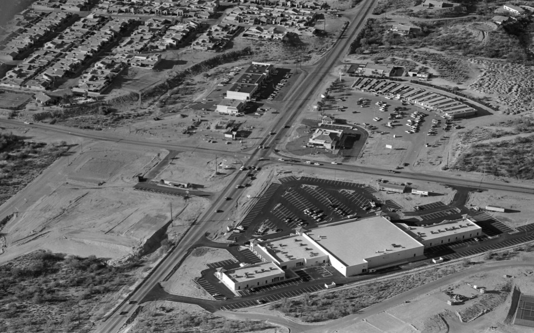
Swan Road and Sunrise Drive in February, 1980. The new Safeway Plaza is bottom right. Catty-corner from the Safeway, a Burger King restaurant is under construction. Across the street, land bladed for a Valley National Bank (now Chase Bank), a restaurant, retail and apartments. The old Rural Metro fire station is behind the street mall at top right.

Oracle Road (left to right) and Ina Road in February, 1980. There were gas stations on three corners of the intersection. All have been demolished. The venerable Casas Adobes Plaza is lower right, now anchored by Whole Foods. The open land at upper right is now the Safeway Plaza. The bank on the corner is still there, but the existing buildings to the right were demolished to make way for parking for the new plaza. Lower left is the property for the Haunted Bookshop, now Tohono Chul Park.

Oracle Road and Magee Road north of Tucson in February, 1980. Plaza Escondida is at right, now anchored by Trader Joe's. The open land at bottom of the photos is now the large retail plaza anchored by Kohl's, Sprouts and Summit Hut. The Circle K (sitting alone, upper left) is now a ballroom dance studio. Note the new asphalt on Oracle Road. In 1977, the state approved a project to widen Oracle Road (a state highway) to six lanes from Ina to Calle Concordia. That may be the last time the road was paved.

Tucson Medical Center in February, 1980. The intersection of Grant and Craycroft roads is at bottom left.

O'Reilly Chevrolet (cluster of cars), then Park Mall (center left) and Broadway Road in February, 1980. The open land at top left is now Williams Centre.

The FICO pecan orchards, bisected by South Nogales Highway, looking north to Sahuarita Road in February, 1980.

Tanque Verde Road (bottom left to upper left) and Wrightstown Road in February, 1980, before the City of Tucson constructed the grade-separated interchange. The first units of the Tanque Verde Apartments are lower left. The Circle K facing Wrightstown at the intersection is now Pair-A-Dice Barbers. The large parking lot and building to the left of the Circle K was the O.K. Corral Steakhouse, which was established in 1968. It closed in 2008. It's now Borderlands Trading Company.

Corona de Tucson Baptist Church, lower right, on Houghton Road south of Sahuarita Road in February, 1980. With exception of some infill housing and a few more trees, the neighborhood looks pretty much the same.

IBM (International Business Machines) on south Rita Road, looking north to the Santa Catalina Mountains in February, 1980. In 1988, IBM began phasing out data storage products manufacturing in Tucson, resulting in the loss of nearly 2,800 workers in Tucson, part of a $600 million consolidation plan.
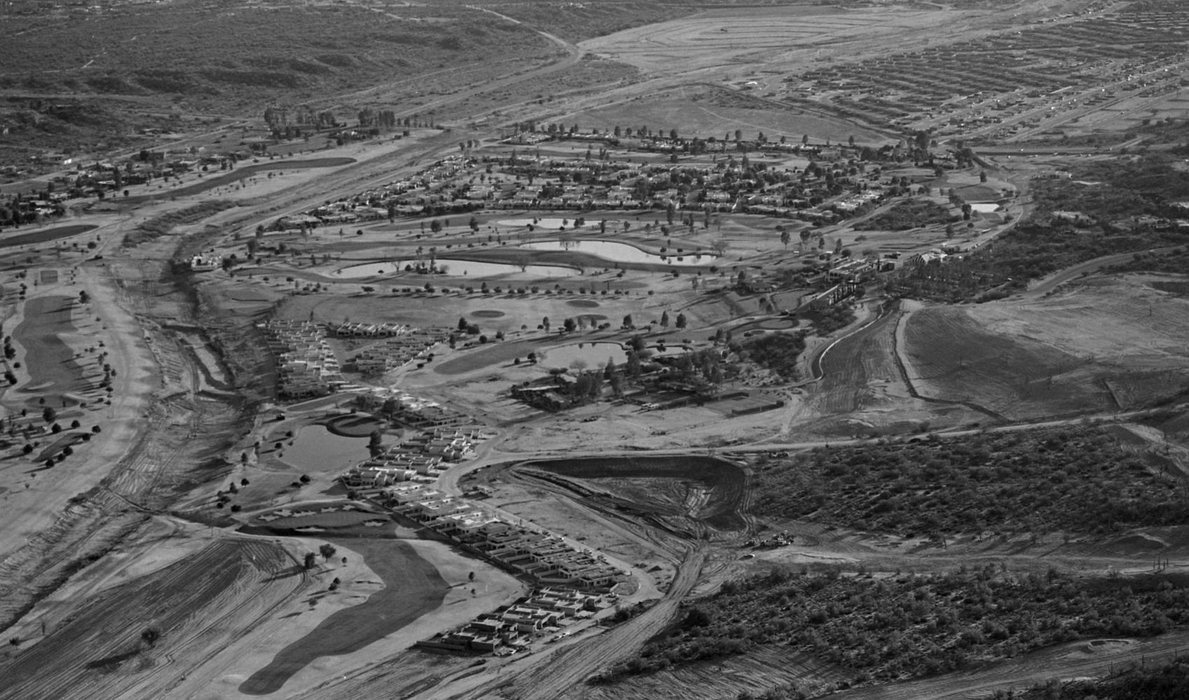
Tucson National Golf Course north of Tucson, looking south, in February, 1980. The Cañada del Oro Wash is at left. Magee Road goes left to right at the top of the photo. Shannon Road curves to the left at top of the photo. That open land is now home to Pima Community College and the YMCA.

