


With hundreds of millions of dollars in disaster relief at stake, New Jersey’s counties are busy updating their emergency response plans. But in a sign of the times, those plans are getting more involved and addressing growing threats of sea level rise and pandemics.
With hundreds of millions of dollars in disaster relief at stake, New Jersey’s counties are busy updating their emergency response plans. But in a sign of the times, those plans are getting more involved and addressing growing threats of sea level rise and pandemics.
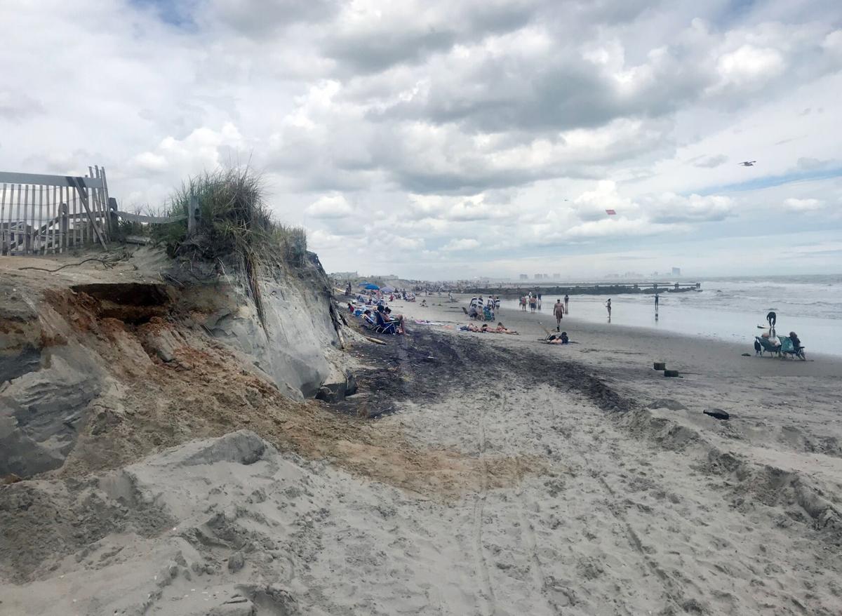
Cape May and Atlantic counties are among others in the state completing their required five-year update on county hazard mitigation plans. Some considerations, like climate change, may have been expected, while others, like pandemics, were not on the schedule until recently.
“(We’re) paying attention to the pandemic. That was never really included in there. There was a public health section, but it never got into any detail. We learned a lot from this pandemic,” said Martin Pagliughi, director of emergency management for Cape May County.
Atlantic County, too, is focusing on the pandemic in its update, which, like Cape May County’s, will be for 2021.
“Part of it is how do we mitigate it? It is a hazard. Whether it’s about evacuation or any day-to-day emergency, you still have to cognizant of that,” said Vince Jones, Atlantic County emergency management coordinator.
Jones said there has been some precedent.
“A few years back, we had the concern of the Ebola virus. We worked real close with the Health Department,” Jones said.
The county hazard mitigation plan is supported by a grant — $125,000 for Cape May County and $126,000 for Atlantic County — from the Federal Emergency Management Agency.
“The 2021 plan update will identify all hazards that threaten our county. Certainly this year everyone has learned when you think it won’t happen, it certainly will,” Pagliughi said.
The update of the plan allows the counties and participating municipalities to continue to be eligible for pre-disaster mitigation funding through FEMA. According to FEMA, up to $500 million will be distributed to states, tribal lands and national mitigation projects. An additional $160 million is available for the Flood Mitigation Assistance Program.
Everyone knows the Atlantic Ocean is salty.
In the region, money received by the coastal counties has historically gone to combat sea-level rise, which is a focused update for Cape May County’s hazard mitigation plan. According to ClimateCentral, a nonprofit based in Princeton, in 2040, sea levels will rise 1.5 feet above the 1992 baseline . In Atlantic City, there were 229 coastal flooding days between 2005 and 2014, 162 of which were driven by climate change.
Pagliughi said one update that’s needed is the county’s list of severe repetitive-loss and repetitive-loss properties. A property is considered a severe repetitive-loss property when the structure has either incurred flood-related damage generating four or more flood insurance loss claims of more than $5,000 each, or at least two claims payments that exceeded the market value of the structure.
“Since Sandy, there’s been quite a few properties that’s been developed. So we’re going to update that list and see what areas (need to be included),” Pagliughi said.
The county is working with TetraTech, a professional consulting firm, to put the plan together. By doing so, the member communities will be able to achieve points in FEMA’s Community Rating System, which offers discounts on flood insurance premiums. Reductions range from 35% in Avalon and Sea Isle City to 15% in Lower Township.

AVALON — Local property owners will notice a drop in their flood insurance premiums this year.
“The big point of getting the points are public awareness, like advertising it in newspapers,” Pagliughi said.
Cape May County’s plan specifically was chosen by the state to be used as a model for other counties.
Jones and Pagliughi said there’s usually some new hazard or major change that needs to be included in their five-year update. In the 2016 plan, Superstorm Sandy caused much of that rewriting. This time, it’s the rise of seas and COVID-19.
“We’re not sitting back, waiting for something to happen. We’re going to actively address this. We have to incorporate this new normal into this planning process,” Jones said.
The record breaking hurricane season is finally over, here were the storm names
The 2020 hurricane forecast increases again in July update
UpdatedThe July 7 Atlantic Hurricane season update from Colorado State University has another increase in the amount of tropical activity expected.
Including the fived named storms that occurred at the time of the July 7 update, which put the 2020 Atlantic Hurricane season on a record breaking pace, CSU forecasts 20, named tropical storms or hurricanes to occur. That is an slight increase from the 19 last predicted in the June update. Out of the 20, 9 hurricanes and 4 major, category 3 or greater (at least 111 mph sustained winds) are forecasted, the same as the June update.
"We have maintained our above-average seasonal hurricane forecast for the 2020 Atlantic season." the CSU report read, which is led by Philip J. Klotzbach, Michael M. Bell, and Jhordanna Jones.
Updated seasonal #hurricane forecast from @ColoradoStateU
— Philip Klotzbach (@philklotzbach) July 7, 2020
continues call for very active 2020 Atlantic #hurricane season. New forecast calls for 20 named storms (including the 5 that have already formed), 9 hurricanes and 4 major (Cat 3+) hurricanes. https://t.co/wIVwJdWMcO pic.twitter.com/OYOMcIIBDz
The 1981-2010 average of activity includes 12.1 tropical storms, 6.4 hurricanes and 2.7 major hurricanes, respectively.
There still remains an above average risk of a major hurricane making landfall on the East Coast of the United States, including the Florida Peninsula. The 45% chance is virtually unchanged from earlier updates On average, there has been a 31% probability in the last century.
CSU attributes warmer than average waters in the subtropical Atlantic Ocean, slightly warmer than average waters in the tropical Atlantic as reasons for the active forecast. Furthermore, a possible transition from a neutral El Nino Southern Oscillation to a La Nina late this summer would promote an active season. In a La Nina, there's a lack of wind shear, or change of winds with height, which can rip storms apart.

What happens in a La Niña, which may develop late in the summer into the fall.
Tropical cyclone names rotate every six years. Exceptionally notable hurricane names, such as Sandy, become retired by the World Meteorological Organization. However, no names were retired in 2014, meaning 2020 will have the same list as then.
Arthur - Used
UpdatedIt's the sixth year in a row that a named tropical system has developed in the Atlantic Hurricane Basin before the June 1 official start.
Bertha - Used
UpdatedTropical Storm Bertha is the second tropical storm or greater storm to have formed in the Atlantic Hurricane basin before the official start June 1. This is only the sixth time since records have been kept in the 1700s that two tropical storm or greater storms have formed before the start.
Even though the official start to the Atlantic Ocean hurricane season is June 1, May has not been shy to tropical systems. Tropical Storm Bertha formed and made landfall off the South Carolina coast Wednesday, putting 2020 in unusual territory.
Cristobal - Used
UpdatedDolly - Used
UpdatedDolly was the third earliest fourth named (D storm) storm in Atlantic Hurricane history, which goes back to 1851. It also flared up further north than any tropical storm before July 1 in recorded history, according to Sam Lilo, postdoctoral researcher at the National Oceanic and Atmospheric Administration
#Dolly has formed in the North Atlantic - the 3rd earliest 4th Atlantic named storm formation on record (since 1851). Danielle is earliest on 6/20/2016. Debby is 2nd earliest on 6/23/2012 at 12 UTC. Dolly in 2020 formed on June 23 at 1615 UTC. #hurricane pic.twitter.com/1Ha6ZnxHqc
— Philip Klotzbach (@philklotzbach) June 23, 2020
Edouard - Used
UpdatedThe Atlantic Hurricane season continued its blistering pace. Edouard, which developed July 6, was the earliest fifth named (with the letter "E") storm in Atlantic Hurricane history, which goes back to 1851. This is according to Philip Klotzbach, Meteorologist at Colorado State University, who issues a highly reputable hurricane forecast each year and is used by The Press.
#Edouard has formed in the far North Atlantic - the earliest 5th Atlantic named storm on record. Previous record was Emily in 2005 on July 12 at 0 UTC. #hurricane pic.twitter.com/K7cB6UKUnq
— Philip Klotzbach (@philklotzbach) July 6, 2020
The previous record was held in 2005 with Emily, which occurred on July 12. 2005 holds the record for the most active hurricane season on record in the Atlantic Hurricane basin, with 27 named storms.
However, all of the storms to this point have all been tropical storms. Some, like Edouard, likely would not have even been noticed before the satellite era, as they were out to sea and may have been missed by shipping routes.
Fay - Used
UpdatedTropical Storm Fay will go in the record books for multiple reasons.
- It is the tenth tropical storm or hurricane to make landfall in New Jersey since 1900.
- It made landfall just south of Holgate, on Long Beach Island, this is, incredibly, about ten miles away from where Tropical Storm Irene and Superstorm Sandy made landfall, right near Brigantine.

Tropical Storm Irene, Superstorm Sandy and Tropical Storm Fay, in a twist of Meteorological conciendence, all made landfall just miles apart.
- Fay was the earliest sixth tropical storm or hurricane to form in the Atlantic Hurricane basin, since records started in 1851. On other words, it was the earliest "F" storm on record.
Gonzalo - Used
UpdatedTropical Storm Gonzalo formed as a tropical depression July 21 and turned into a named storm July 22.
Hanna - Used
UpdatedTropical Storm Hanna formed Thursday, July 24. That put the 2020 hurricane season in a big lead over the 2005 hurricane season for the quickest, most active start. In 2005, Harvey formed on August 3, putting the 2020 season roughly two weeks ahead of 2005.
According to Retired National Weather Service Meteorologist Jim Eberwine, this was the first time in 22 that there have been eight tropical storms, without any hurricanes. However, its upgrade to a hurricane July 25 meant this streak was broken.
#Hanna has formed in the Gulf of Mexico - the earliest 8th Atlantic named storm formation on record. Prior record was Harvey on August 3, 2005. #hurricane pic.twitter.com/m1cuFjb0ff
— Philip Klotzbach (@philklotzbach) July 24, 2020
Isaias - Used
UpdatedThe fourth largest power outage event in Atlantic City Electric's history came with Isaias, which passed to the west of New Jersey as a tropical storm.
Isaias continues the blistering pace of the hurricane season, beating out the 2005 season. The "I" storm then, Irene, developed on August 7.
The "I" storm in the 2020 Atlantic Hurricane Season name is Isaias, the Spanish word for the name Isaiah. Denise Arrigo, Adjunct Professor at Cumberland County College and formed Spanish Teacher at Millville Senior High School, explains how to pronounce the word.
Hurricane Irene would be retired by the World Meteorological Organization in 2011. The storm brought power outages to over 100,000 in South Jersey, a tornado in Vineland and nearly a foot of rain to the Wildwoods.
This also ties the record for the most number of July tropical systems in a month, at five.
Josephine
UpdatedKyle
UpdatedLaura
UpdatedMarco
UpdatedNana
UpdatedOmar
UpdatedPaulette
UpdatedRene
UpdatedSally
UpdatedTeddy
UpdatedVicky
UpdatedWilfred
UpdatedWhat if we get past Wilfred?
UpdatedThen, we go Greek.
The rules for hurricane names state that once the list is exhausted, storm names go by Greek letter of the alphabet. This has only been used once, and that was for the 2005 Atlantic Hurricane season that 2020 is on pace to break.
The next five storm names after Wilfred go in the following order:
Alpha
Beta
Gamma
Delta
Epsilon
Joe's 7-Day Forecast
UpdatedAlpha - Used
UpdatedFor the second time in history and the first time since 2005 the list of storm names have been exhausted.
Subtropical storm Alpha is the first Greek storm name of the season. Perhaps fitting for its name, it has charted its own path, crashing into Portugal as a mid-level stom Sept. 18.
Beta - Used
UpdatedGamma - In Progress
UpdatedAfter a break for nearly a week, Gamma spawned in the Gulf of Mexico. According to Klotzbach, Gamma is aggressively beating out the 2005 season.
Delta - In Progress
UpdatedTropical Storm Delta formed from a tropical depression on Oct. 5. Delta is forecasted bring impacts to the U.S. Gulf Coast late in the week.
Note that storms in the Greek alphabet can be retired if they are significant enough. However, the World Meteorological Organization will continue to use the storm name if the situation warrants. Only 2005 has even had storm names in the Greek alphabet, so it is a rare occurrence.
Epsilon - In Progress
UpdatedAccording to Klotzbach, Epsilon, which formed on Oct. 19, is the earliest 26th named storm of the season in recorded history. In 2005, that storm developed on Nov. 22, 2005.
Zeta - In progress
UpdatedTrack hurricane season with our interactive map
UpdatedTrack all of the active tropical systems, along with their movement, wind speeds and weather alerts here.
Eta - In progress
UpdatedEta, the twenty-eight named storm of the year, developed Nov. 1. Officially, 2020 tied the 2005 for the most tropical storms and hurricanes in one season in the Atlantic Hurricane Basin. Records go back to the mid-1800s, but more reliably since the 1960s.
Besides the number of storms, how does 2005 compare to 2020?
UpdatedJoe's 7-Day Forecast
UpdatedTheta (Breaks record) - In progress
UpdatedSubtropical Storm Theta is the twenth-ninth tropical storm or hurricane in the Atlantic Ocean Basin, besting 2005 for the most active hurricane season on record. Records go back with a high degree of accuracy to the 1960s, when satellites kept an eye on the oceans. However, observations on hurricanes have been made with regularity since the mid-1800s.
Iota - In Progress
UpdatedTropical Storm Iota formed on Nov. 13 from Tropical Depression 31, continuing the record pace.
Support South Jersey journalism at The Press of Atlantic City
UpdatedMeteorologist Joe Martucci loves forecasting for our towns in South Jersey. Subscribing to The Press of Atlantic City ensures your stories are being told. Go to pressofac.com/subscribe for our best offers. You can subscribe for a print and digital subscription, or take part in a digital-only package.

