


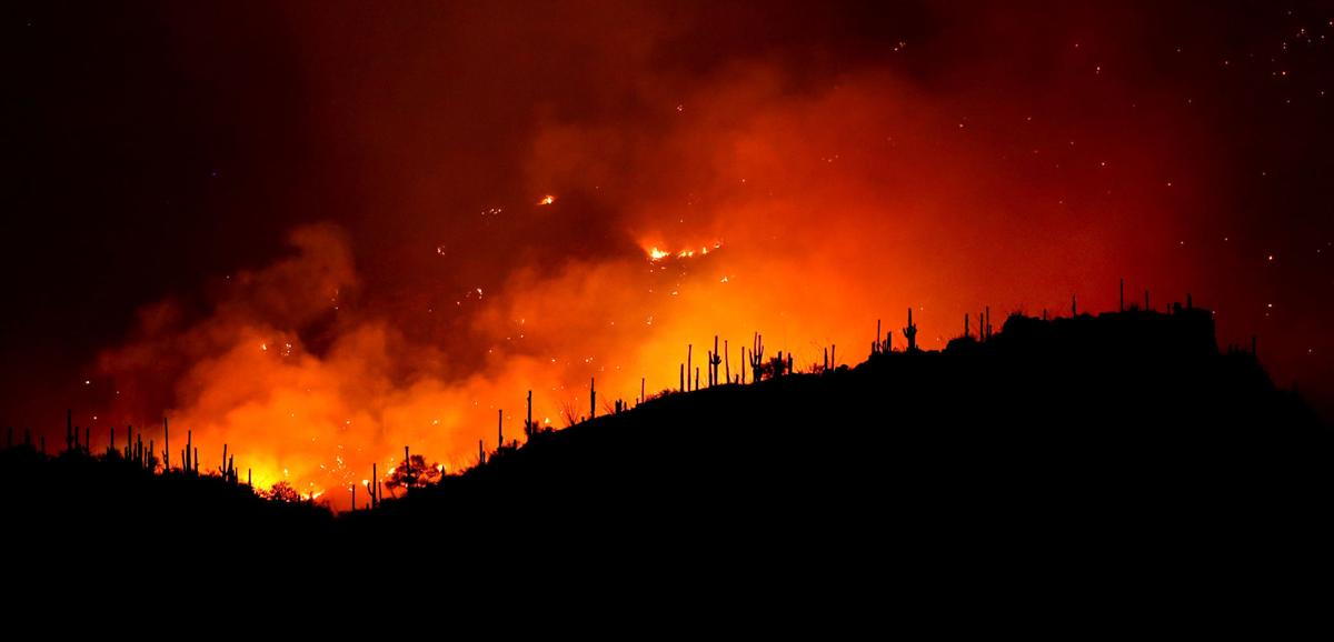
The Bighorn Fire grew to more than 88,000 acres by Friday morning, surpassing the size in acres of the 2003 Aspen Fire that burned through Summerhaven and resulting for an evacuation of an area on the east side of the blaze.
The 84,000-acre Aspen Fire destroyed more than 300 homes and businesses in the town that’s a popular escape for Tucsonans. No property atop Mount Lemmon has burned in the Bighorn Fire, which has remained steady this week at about 33% containment.
However, a surge in the fire along its east edge prompted an evacuation order late Friday afternoon for an area south of the Pima County line and west of the community of Redington, the Pima County Sheriff’s Department said.
On Friday afternoon, Andy Huntsberger, an operations section chief with the Northern Rockies Incident Management Team, said the east edge of the wildfire had been pushed by west winds. “We are looking at all kinds of options to bring it under containment,” Huntsberger said of the eastern edge of the blaze.
"We're tough as saguaros," editorial cartoonist David Fitzsimmons says. He says he saw a video made for the people of Detroit and became inspired to do his own take for Tucson.
Meanwhile, the western edge of the fire near Catalina State Park has nearly “stopped moving” because of a lack of fuel, said Huntsberger, adding that the north end of the wildfire has also remained within the containment lines.
“We’re in good shape with the work we’ve done so far,” Scott Schuster, an incident commander with the the Northern Rockies Incident Management Team said Friday morning about fire lines and other buffers created around areas surrounding Oracle and SaddleBrooke.
Some 1,100 people are assigned and more than $25 million has been spent so far to fight the wildfire.
Schuster said firefighters were expecting to be challenged by wind throughout the day Friday as well as low humidity, which has helped fuel flare-ups in different parts of the Santa Catalinas this week.
“All those areas on the top of the mountain are looking in good shape,” Schuster said, describing a “green doughnut” of fire protection established around Summerhaven, Willow Creek and the Catalina Highway.
He predicted an uptick in smoke Friday that would be visible across Tucson, but added that the increase in smoke is “not a concern to firefighters.”
Flames were expected to burn in the lower Catalina Foothills, but fire lines and other buffering there is strong, and crews are ready to respond quickly, he said.
The area around the upper Sabino Canyon had quieted too. Helicopters dropped huge buckets of water there Thursday.
Crews in the Summerhaven area have been working to improve containment lines and buffer areas. The fire had been active near Maverick Spring and Green Mountain northeast of Willow Canyon, but containment efforts there remain strong.
Tucson's Bighorn Fire: Wildfire's smoke can be seen from space
NASA satellite captures smoke from Bighorn Fire near Tucson
Updated
NOAA/NASA's Suomi NPP satellite captured this image of the Bighorn Fire on June 22, 2020, showing clouds of smoke pouring off this fire that is plaguing Arizona.
NASA image shows Bighorn Fire's 63-mile smoke plume
Updated
NOAA/NASAs Suomi NPP satellite image is overlaid with rulers from the Worldview program which shows how far the smoke has traveled from the Bighorn Fire. In the southeast direction it has traveled up to 63 miles and to the northeast it is traveled to 41 miles from the fire. June 22, 2020.
Arizona and New Mexico fires image taken by satellite
Updated
Fires in Arizona and New Mexico stretch across this image taken by NOAA/NASA’s Suomi NPP satellite on June 22, 2020.
Arizona and New Mexico wildfires
Updated
A closer look at smoke from Arizona and New Mexico fires.
ZOOM Earth photos shows Bighorn Fire
Updated
This ZOOM Earth satellite photo was taken on the afternoon of June 25, 2020, and shows smoke from the Bighorn Fire.

