


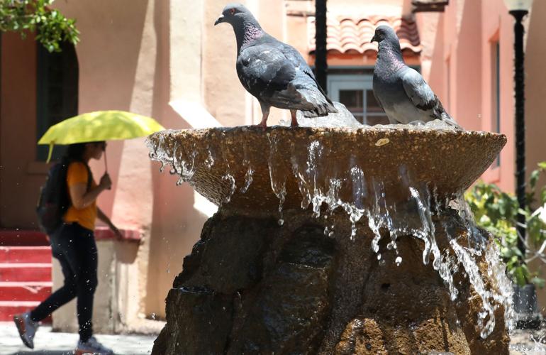


Tucsonans face a weekend of near-record highs and excessive heat warnings.
But relief is within sight — really.
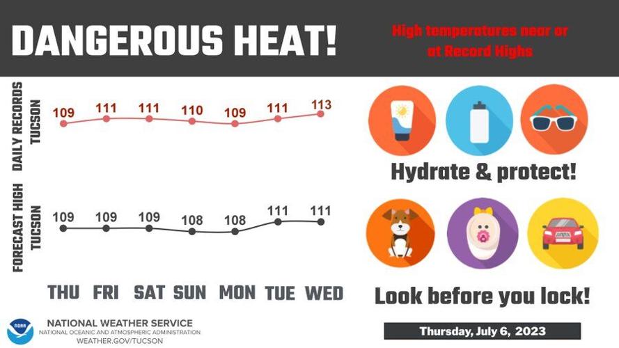
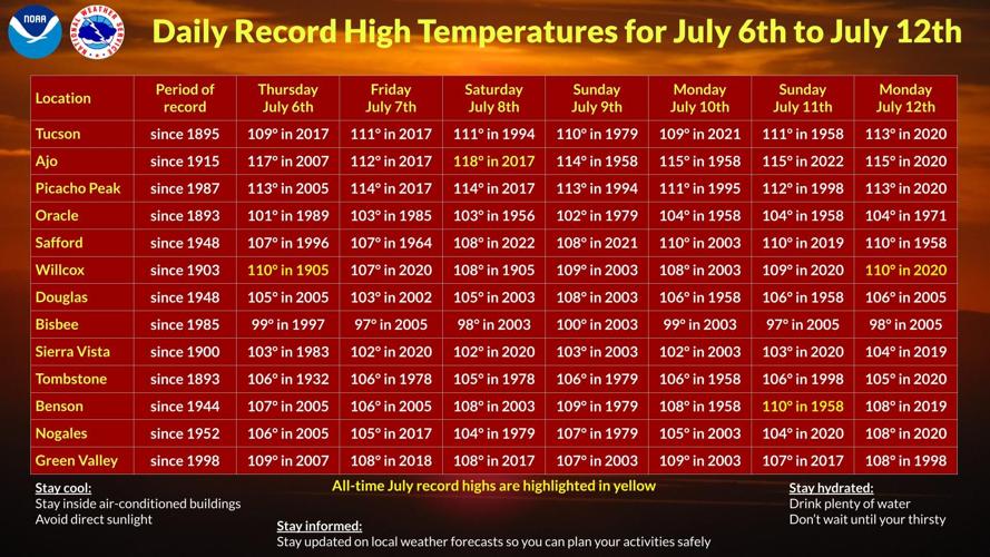
It reached 110 degrees Thursday, topping the previous record for July 6, of 109 degrees in 2017, according to the National Weather Service in Tucson.
Thursday also marked the first of seven straight days expected to approach or pass record-high temperatures here.
Friday and Saturday are each expected to reach 109 degrees, just two degrees short of the current record highs dating back to 2017 and 1994, respectively.
Sunday and Monday are each forecast to be 108 degrees, below record-highs of 110 degrees in 1979 and 109 degrees in 2021 for the two respective dates.
Tuesday is expected to reach the current hottest July 11 on record, 111 degrees. That record high was set in 1958.
Tucson is entering the longest consecutive streak of over-100-degree days this decade.
Currently, that record is held in 2020, when Tucson hit triple digits from July 6 through August 20. If the expected highs hold over the next few days, that record will fall on Wednesday.
So far in 2023, Tucson has had four days of high temperatures above 110 degrees. That’s twice the historic average for June and July, along with twice the amount of plus 110-degree days between May and August of 2022, Weather Service data shows
While high temperature for July 12 is expected to be 111 degrees, the chance of rain is expected to creep up.
The last official rainfall in Tucson was May 19. The 48 consecutive days of no rain ranks as the 82nd all-time rainless period for Tucson. But 1950 was even drier. From Sept. 8 to Dec. 30 of that year — 114 consecutive days — had no rain, Weather Service data shows.
The 2023 monsoon has yet to arrive so we're taking a look back at last year's stormy season in Tucson.
The area’s lack of precipitation is mostly due to where the upper-air highs are located in relation to the region, a measure of how the weather is behaving in Earth’s atmosphere.
Moisture-driven winds that come from the Gulf of Mexico and the Gulf of California are being cut off, mainly due to the upper high being more southern than meteorologists would like it to be to trigger rain here. Ideally this would be situated over the Four Corners area. With the upper-level highs being situated in the south and a lack of moisture over northern Mexico, high-and-dry winds are the only thing Tucson has encountered so far in this year’s monsoon season, the Weather Service says.
“The high’s expected to move east and we’re expecting to see a little of bit of moisture,” Lance Tripoli, a meteorologist at the National Weather Service in Tucson, said about next week.
According to the seven-day forecast for the region, chances of rain begin late on Sunday night, and it increases to about 30% Monday through Thursday nights.
During the coming days of hot days, the Weather Service recommends avoiding outdoor activities through the hottest parts of the day — generally between 10 a.m. and 7 p.m.
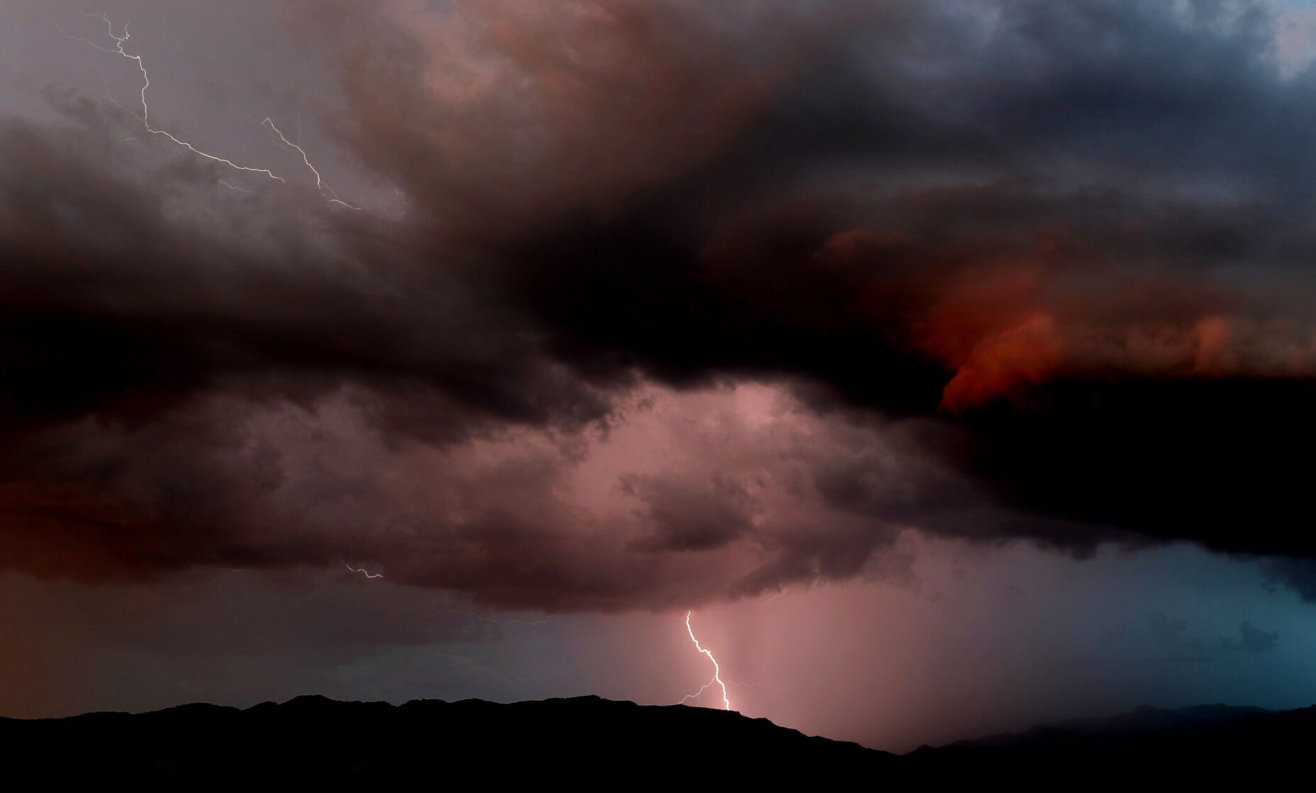
Photos: 2022 monsoon around Tucson

Pedestrians wade through a flooded 2nd Street just east of Park Avenue when an unexpected monsoon storm dumped inches of rain in the midtown area, Tucson, Ariz., Sept. 28, 2022.
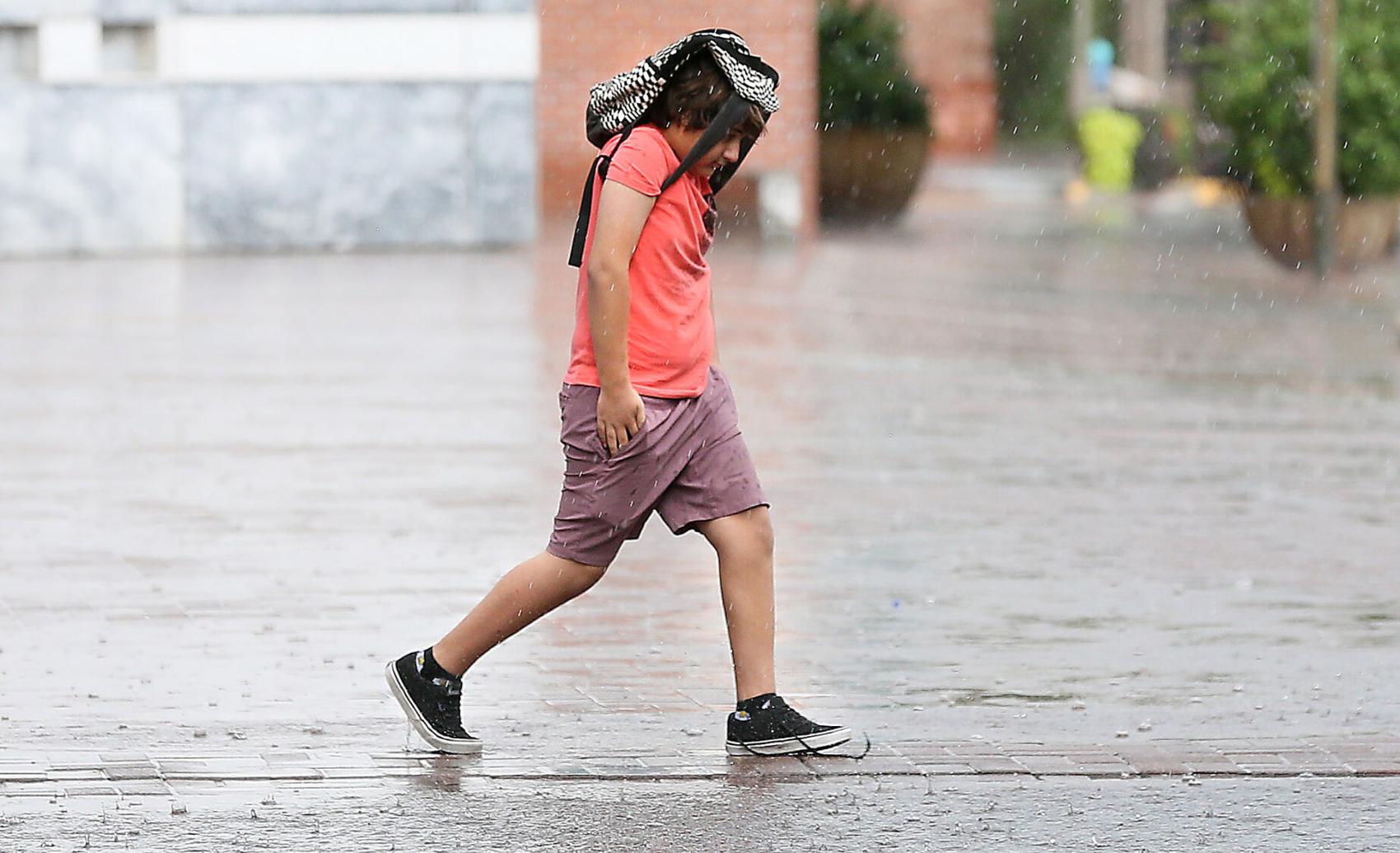
A boy uses his backpack to shield himself from the monsoon storm in downtown Tucson, Ariz. on September 28, 2022.

A rainbow appears over the historic Pima County Courthouse following a rainstorm in downtown Tucson, Ariz. on Sept. 13, 2022.

George Lucero, right, holds an umbrella while talking and watching a rainstorm with David DeBergalis at Babad Do'ag scenic overlook on the Catalina Highway on Sept. 21, 2022.

Tucson Fire Department Ladder 16 helped a victim safely out of the Alamo Wash just south of 22nd Street around 8 p.m Thursday, Aug. 25.

Tucson Electric Power workers watch while a utility pole snapped during a monsoon storm is slowly raised along South Kolb Rd, between East Golf Links Rd. and East Escalante Rd. On Thursday. North bound traffic is closed along South Kolb Rd. between East Golf Links Rd. and East Escalante Rd. while the work progresses.

A Tucson Electric Power crane slowly raises a damaged power pole along South Kolb Rd, between East Golf Links Rd. and East Escalante Rd., on Thursday.

A utility pole snapped during a monsoon storm rests on a home along South Kolb Rd, between East Golf Links Rd. and East Escalante Rd. on Aug. 25, 2022.

South bound traffic pass Tucson Electric Power while TEP works along South Kolb Rd, between East Golf Links Rd. and East Escalante Rd., to repair multiple power poles in Tucson, Ariz. on Aug. 25, 2022. The poles were damaged due to a monsoon storm. Work is expected through the week. North bound traffic is closed along South Kolb Rd. between East Golf Links Rd. and East Escalante Rd.

Tucson Electric Power employees work on a newly installed power pole while other TEP employees work along South Kolb Rd, between East Golf Links Rd. and East Escalante Rd., to repair multiple power poles in Tucson, Ariz. on Aug. 25, 2022. The poles were damaged due to a monsoon storm. Work is expected through the week. North bound traffic is closed along South Kolb Rd. between East Golf Links Rd. and East Escalante Rd.

Tucson Fire Department personnel perform a swift water rescue for a man trapped by flood waters under the Blacklidge Drive bridge at Walnut Avenue, Tucson, Ariz., August 24, 2022. The man refused treatment at the scene.
A time lapse of a storm cell falling apart east of downtown Tucson as sun sets, August 27, 2022. Monsoon 2022 appears to be winding down. Kelly Presnell / Arizona Daily Star

Lightning hits behind Tumamoc Hill just after sunset as a several monsoon storms move through Tucson, Ariz., August 23, 2022. The storms produced localized flooding from heavy rains, especially in the southern portions of the area.

Lightning strikes just west of Tumamoc Hill from a cell that built up just to the south of Tucson, Ariz., August 23, 2022. Several cells formed around the valley just before sunset, dropping rain and causing some localized flooding.

A large lightning strike silhouettes Tumamoc Hill, part of a series of monsoon storms that built up over the valley and Tucson, Ariz., August 23, 2022.

Two bolts of lightning strike near Sentinel Peak and southern Tucson, Ariz., August 23, 2022. Several storms brewed up around the area, producing heavy rain

A bolt of lightning hits to the west of Tumamoc Hill during sun set, one several monsoon storms that dropped rain as well throughout Tucson, Ariz., August 23, 2022.

A couple walks in the rain at El Presidio Plaza as a monsoon storm travels across downtown Tucson August 19, 2022. Rain is expected throughout the weekend.

A waving motorcyclist ridings along North Soldier Trail while water from the Agua Caliente Wash flows over Soldier Trail in Tucson, Ariz. on Aug. 21, 2022.

A kayaker finishes riding the water inside the Rillito River near North Campbell Ave. and East River Rd. in Tucson, Ariz. on Aug. 21, 2022.

A motorist drives along North Soldier Trail while water from the Agua Caliente Wash flows over Soldier Trail in Tucson, Ariz. on Aug. 21, 2022.

A kayaker travels down the Rillito River near North Campbell Ave. in Tucson, Ariz. on Aug. 21, 2022.

Cyclists ride along the Rillito River Park Trail while storm water flows inside the Rillito River under North Campbell Ave. in Tucson, Ariz. on Aug. 21, 2022.

A family looks at the running water inside the Rillito River while walking along the Rillito River Park Trail near North Craycroft Rd. and East River Rd. in Tucson, Ariz. on Aug. 21, 2022.

A dog swims inside the Rillito River near North Campbell Ave. and East River Rd. in Tucson, Ariz. on Aug. 21, 2022.

A semi-shrouded lightning bolt illuminates a shaft of rain dropping on the north-central part of town as a monsoon cell begins growing over Tucson, Ariz., August 17, 2022. Rain, at times heavy, and lightning fell over most of the valley during the early evening and into the night.

A car zooms through the foot-deep water flooding the intersection of Glenn Street and Tucson Boulevard, the after effect of a monsoon storm that expanded over Tucson, Ariz., August 17, 2022. The storm dropped rain over much of the valley starting shortly before sunset and into the night.

Lightning strikes the Santa Catalina Mountains near Pima Canyon during a monsoon storm on Aug. 10, 2022.

Lightning strikes the Santa Catalina Mountains near Pima Canyon during a monsoon storm on Aug. 10, 2022.

Monsoon storm moving Marana across slowly obscures the view of Picacho Peak 20 miles to the northwest on Tuesday, Aug. 9, 2022.

The clouds open and rain pours from a monsoon storm moving across the Tucson Mountains into Marana on Tuesday, Aug. 9, 2022.

A monsoon storm moves across Marana and into the Tortolita Mountains on Tuesday, Aug. 9, 2022.

Power lines down on Linda Vista Drive between N. Bald Eagle Ave. and W. Waterbuck Drive after a powerful monsoon storm moved across the Tucson Mountains into Marana on Tuesday, Aug. 9, 2022.

Power lines down on Linda Vista Drive between N. Bald Eagle Ave. and W. Waterbuck Drive after a powerful monsoon storm moved across the Tucson Mountains into Marana on Tuesday, Aug. 9, 2022.
A thunderstorm filled the night sky with light on Aug. 10, as seen in this clip filmed near East Grant Road and North Euclid Ave. Video by Pascal Albright / Arizona Daily Star.

Lightning strikes the ground while a monsoon storm passes over the Rincon Mountains on the east side of Tucson, Ariz. on Aug. 7, 2022 as seen from Babad Do'ag Scenic Overlook in the Santa Catalina Mountains.

Visitors watch a monsoon storm as it passes over the Rincon Mountains on the Eastside of Tucson, Ariz. on Aug. 7, 2022 as seen from Babad Do'ag Scenic Overlook in the Santa Catalina Mountains.

A monsoon storm passes over the Rincon Mountains on the east side of Tucson, Ariz. on Aug. 7, 2022 as seen from Babad Do'ag Scenic Overlook in the Santa Catalina Mountains.

A large bolt hits the southern end of the Rincon Mountain foothills, near Colossal Cave Road and Mary Ann Cleveland Way, part of a monsoon storm that spread rain, wind and hours of lightning in Vail, Ariz., August 7, 2022.
The last of the day's light hits monsoon storm clouds while lighting strikes in the Rincon Mountain foothills in Vail, Ariz., August 7, 2022.

Lightning strikes in the southern Rincon Mountain foothills, the second night in row a monsoon storm moved in from the east and through Vail, Ariz., Aug. 7, 2022.

The day's dying light catches the high monsoon storm clouds while lighting strikes in the Rincon Mountain foothills in Vail, Ariz., August 7, 2022.
The Tucson monsoon gave heavy rain and thunder and lightning storms on Aug. 8, 2022. More thunderstorms are expected today in southeast Arizona, according to the National Weather Service.

A bolt of lightning hits the southern slopes of the Rincon Mountains shortly after sunset, part of a monsoon storm as it rolls in over Vail, Ariz., August 6, 2022. Steady light rain was preceded by gusty winds as well as the light show.

Twin bolts hit the southern slopes of the Rincon Mountains as a monsoon storm rolls in over Vail, Ariz., Aug. 6, 2022. High winds and rain also flowed through the area into the night.

A large bolt touches down in the foothills of the southern Rincon Mountains, one of hundreds of lightning strikes generated from just before sunset until far into the night by a monsoon storm over Vail, Ariz., August 6, 2022.

Shortly after sunset, a monsoon storm rolls in over Vail, Ariz., August 6, 2022. The storm brought gusty winds, rain and hours of lightning as it headed northeast and into the Santa Cruz valley.

A monsoon storm rolls in over Vail, Ariz., Aug. 6, 2022, dropping rain as well as lightning in the Rincon Mountains and foothills. Lightning was hitting throughout the area for several hours.

A large bolt hits in the lower reaches of the Rincon Mountain foothills as the monsoon storm makes its way into Vail, Ariz., August 6, 2022.

Three bolts in the vanguard of a monsoon storm strike the Rincon Mountains as it heads northwest and over Vail, Ariz., August 6, 2022.

Two bolts of cloud-to-ground lightning fall from into the Rincon Mountain foothills from monsoon storm rolling west and into Vail, Ariz., August 6, 2022.

Multiple ground strikes as well as cloud-to-cloud lighting flashes around a home on a ridge southeast of Tucson, Ariz., Aug. 3, 2022. The storm was mostly east of the Rincon Mountains until midnight. Another band was moving to the west just south of the city.

Lightning and a column of rain from a late night monsoon storm rolls over the area southeast of Tucson, Ariz., August 3, 2022. Frequent cloud-to-cloud as well as ground strikes were over the Vail area for much of the evening into the early morning hours.

Rain and lightning from a late night monsoon storm rolls over homes on a ridge southeast of Tucson, Ariz., August 3, 2022.
A time-lapse of a monsoon cell trying to get organized over the southeastern parts of the Tucson, Ariz., area just as darkness falls, August 3, 2022. Video Kelly Presnell / Arizona Daily Star

A woman walks with her umbrella as a sprinkle of rain falls in downtown Tucson on Aug. 3, 2022.

A woman walks along Sixth Avenue as a sprinkle of rain falls in downtown Tucson on Aug. 3, 2022.

Pima County Wastewater Reclamation crew members clear sand and rocks from a manhole at Havasu Road southeast of Columbus Blvd. inside Coronado Foothills Estates in Tucson, Ariz. on Aug. 1, 2022. A monsoon storm filled Finger Rock Wash as well as streets and a handful of homes on Sunday night.

Residents watch as crew members work to clear out rocks, dirt and mud off Havasu Road southeast of Columbus Blvd. inside Coronado Foothills Estates in Tucson, Ariz. on Aug. 1, 2022. A monsoon storm filled Finger Rock Wash as well as streets and a handful of homes on Sunday night.

A Pima County Wastewater Reclamation crew member, right, reacts as water spills out of a tube while crew members work to clear sand and rocks from a manhole at Havasu Road southeast of Columbus Blvd. inside Coronado Foothills Estates in Tucson, Ariz. on Aug. 1, 2022. A monsoon storm filled Finger Rock Wash as well as streets and a handful of homes on Sunday night.

While crews work to clean up the damage from Sunday evenings monsoon storm, a Havasu Road and Columbus Blvd. sign lies on the side of road farther southeast then the Havasu Rd and Columbus Blvd. corner inside Coronado Foothills Estates in Tucson, Ariz. on Aug. 1, 2022. A monsoon storm filled Finger Rock Wash as well as streets and a handful of homes on Sunday night.

A residents car is stuck in a pile of mud along East Havasu Rd inside Coronado Foothills Estates in Tucson, Ariz. on Aug. 1, 2022. A monsoon storm filled Finger Rock Wash as well as streets and a handful of homes on Sunday night.

Resident Maria Perri shovels some dirt along East Havasu Rd. in front go her home inside Coronado Foothills Estates in Tucson, Ariz. on Aug. 1, 2022. A monsoon storm filled Finger Rock Wash as well as streets and a handful of homes on Sunday night. "It was a raging river down here," said Perri. Some residents hung out in her drive way to get away from the flooding, added Perri.
The National Weather Service issued a flash flood warning in the Sabino Canyon area on Friday, Aug. 12. The water forced bridges to close down and left some hikers stranded and waiting for the water to subside. Video by Susan Barnett.

Workers from Pima County Wastewater Reclamation clear sand and rocks from a manhole at Havasu Road and Columbus Blvd. in the Catalina Foothills on Monday, Aug. 1, 2022, after a raging Finger Rock Wash swamped a handful of homes on Sunday night.

Boulders and debris block Havasu Road at Columbus Blvd as seen on Monday, Aug. 1, 2022, after a raging Finger Rock Wash that swamped a handful of homes on in the Catalina Foothills on Sunday night.

A mud-splattered wheelchair at an adult care home on Havasu Road in the Catalina Foothills on Monday, Aug. 1, 2022. Rural Metro firefighters evacuated the residents after a raging Finger Rock Wash swamped a handful of homes on Havasu Road east of Columbus Blvd. in the Catalina Foothills on Sunday night.

A street sign fell victim to floodwaters on Havasu Road east of Columbus Blvd as seen on Monday, Aug. 1, 2022, after a raging Finger Rock Wash swamped a handful of homes on Sunday night.

A cyclist rides along The Loop at Grant Road next to the Santa Cruz River swollen with runoff from midtown Tucson storm on July 26, 2022.

Monsoon clouds rise above the desert floor southeast of Tucson, behind Tumamoc Hill on July 26, 2022.

A monsoon storm begins dropping rain as it grows to the southeast of Sonoita, Ariz., July 29, 2022. The cell was one of several that formed over the area, dumping rain on the plain for much of the afternoon.

A US Border Patrol truck heads east on State Route 82 as a monsoon storm boils up to the south just outside Sonoita, Ariz., July 29, 2022.

The statue, Tribute to Ranching, stands under a growing monsoon cloud outside the Santa Cruz County Fair & Rodeo Association grounds, Sonoita, Ariz., July 29, 2022. The cell was one of several that dumped rain on the area throughout the afternoon.
The leading edge of flood waters, spurred by a few days of monsoon rain, slowly makes its way down the channel of the Tanque Verde Wash at Wentworth Road Thursday afternoon, July 28, 2022, Tucson, Ariz. Video Kelly Presnell / Arizona Daily Star

Onlookers get video and photos while watching the debris filled leading edge of water fill the Tanque Verde Wash at Wentworth Road, Tucson, Ariz., July 28, 2022. Heavy monsoon rains over the past few days has water flowing in some of the area washes and low lying areas.

Birdie the Golf Dog takes a cooling break in the water beginning to fill the Tanque Verde Wash at Wentworth Road, Tucson, Ariz., July 28, 2022.

Paul Delligatti lines up his shot while recording video of the leading edge of floodwaters in the Tanque Verde Wash flow across Wentworth Road, Tucson, Ariz., July 28, 2022.

Dustin Ovayvar, left, and his family, were among the handful that waited to catch the arrival of the leading edge of the waters heading down the Tanque Verde Wash at Wentworth Road, Tucson, Ariz., July 28, 2022.

Tom Woodrow and his mother Diane wade through the northern channel after getting cut off watching the water fill the southern branch of the leading edge of flood water in the Tanque Verde Wash flow over Wentworth Road, Tucson, Ariz., July 28, 2022.

Tucson Fire Department personnel pull a man out of the floodwaters of the Arroyo Chico rushing through a construction channel near 9th Avenue just north of 6th Street during a monsoon storm that dumped inches of rain on parts of Tucson, Ariz., July 26, 2022. The man was eventually carried to a nearby ambulance.

A driver has second thoughts about driving into the flooded Arroyo Chico in midtown during a monsoon, Tucson, Ariz., July 26, 2022. The driver eventually turned around.

A driver takes his SUV into the running waters of the Arroyo Chico in midtown during a monsoon storm, Tucson, Ariz., July 26, 2022.

A Jeep blasts at high speed into the flooded Arroyo Chico after a monsoon storm dumped inches of rain on parts of Tucson, Ariz., July 26, 2022.

A woman and her curious dog get a closer look at the flood waters of Arroyo Chico running over Plummer Avenue during a monsoon storm that dumped inches of rain over parts of Tucson, Ariz., July 26, 2022.

A driver takes a jeep through the high waters of Arroyo Chico running over Plummer Avenue during a monsoon storm through the area, Tucson, Ariz., July 26, 2022.

Krishna Ghimire and Sumod Bastakoti take a selfie of themselves with storm clouds approaching from Sentinel Peak Park on July 26, 2022.
Time lapse shows a large monsoon storm building up to the south and eventually spreading into Tucson, dropping nearly an inch or more of rain in less than an hour in Vail and midtown Tucson, causing local flooding and a few swift water rescue calls, July 26, 2022. Video by Kelly Presnell / Arizona Daily Star

A lightning bolt hits in the valley as an afternoon monsoon storm rolls over east central Tucson, Ariz., July 22, 2022.

The setting sun lights up the patchy monsoon clouds overhead as Omar Rojas Jr. works on pitching out of the stretch with his dad, Omar Sr., on the diamond at David G. Herrera and Ramon Quiroz Park, Tucson, Ariz., July 21, 2022. The two Omars were working out while daughter/sister Julissa practiced nearby with her softball team. Monsoon 2022 may finally bring the rain, with precipitation forecast this weekend and throughout the coming week.

Mammatus clouds roll over the evening skies west of the Tucson Mountains during a little light monsoon activity around Tucson, Ariz., July 15, 2022.

With a monsoon cell dropping a bit of rain to the west, fans find seats in the grandstands long the strip during Street Rally night at the Tucson Dragway Tucson, Ariz., June 11, 2022.

Sarah Travis and her son John Donnelly, on shovel duty, and his friend Kai Squire, take advantage of the Department of Transportation and Mobility's sandbag filling site in the east parking lot of Hi Corbett Field, Tucson, Ariz., June 17, 2022. The trio were helping a neighbor in need get ready for the coming rains. This is the seventh year DTM is providing bags and sand for residents to make sandbags to deal with monsoon flooding.

Pima County crews expanded the Chuck Huckelberry Loop along the Canyon del Oro Wash north of Magee Road on June 7 and cleared out brush in the channel and performed flood control measures to prevent water from monsoon rains flooding the path.

A vehicle travels down North Houghton Rd. while a small storm passes over the Santa Catalina Mountains in Tucson, Ariz. on June 27, 2022.

Two vehicles drive through a series of puddles on East Speedway after a rain storm passed through the Eastside of Tucson, Ariz. on June 27, 2022.
A time lapse catches the sun set over the exhibits at Pima Air & Space Museum as they open their doors for the final evening session of Night Wings. Video Kelly Presnell / Arizona Daily Star

A crew with Hunter Contracting Co. work on a pathway surrounding a new storm basin while monsoon clouds build to the south of Cherry Avenue Park in Tucson, Ariz. on June 29, 2022.

A rainbow fragment above Pima Canyon and the Santa Catalina Mountains on June 27.

Monsoon clouds over the Tohono O'Odham Nation loom behind the towers on Tumamoc Hill on June 28.

Olga Martinez, far left, and her daughter Raquel Diaz watch a monsoon storm pass over the Santa Catalina Mountains from "A" Mountain in Tucson, Ariz. on July 24, 2022.

