


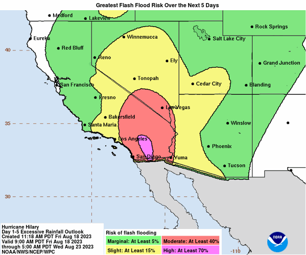

Tucson has a 50-50 chance of rain this weekend as it sits on the outer edges of the projected path of a hurricane that was churning Friday toward California.
Hurricane Hilary was off Mexico’s Pacific Friday as a powerful Category 4 storm. It was threatening to unleash torrential rains on the mudslide-prone border city of Tijuana before heading into Southern California as the first tropical storm there in 84 years, the Associated Press reported Friday.
Forecasters warned the storm could cause extreme flooding, mudslides and even tornadoes across the region.
No tropical storm has made landfall in Southern California since Sept. 25, 1939, according to the National Weather Service.

NHC is predicting at least a five percent chance of flash flooding in the Tucson area, however chances grow in more western portions of the state. Issued by the NHC on Friday, Aug. 18.
Southern Arizona could get peripheral activity from the hurricane. The projected path Friday showed the metro Tucson area on the furthest edges of the hurricane’s path with areas like Yuma more likely to get significant rain and wind.
Meanwhile, an unrelated storm Thursday night hit Tucson’s northwest side.
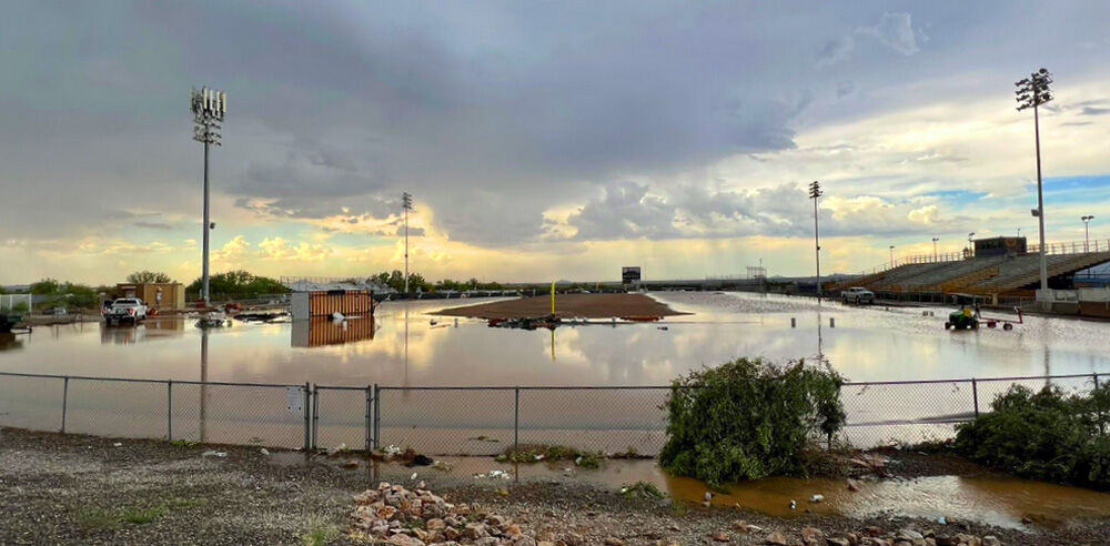
Storm damage at Marana High School was so severe that classes were canceled Friday.
The school was still without power Friday afternoon.

A storm on Aug. 17 proved especially damaging to the Marana High School campus. Damage was extensive; a new turf is on order, and Marana’s first four games are now on the road.
The most significant damage to the campus occurred on its outdoor facilities, like flooding of athletic fields and mangled fences, a statement from the district said.
“New turf on the football field, which recently had been installed to replace aging turf, was rolled up by the wind,” officials said. “Around campus, numerous large shade trees and saguaro cacti were knocked over. The campus greenhouse and outbuilding were either torn apart or relocated due to the wind.”

Thursday’s storm proved to be especially damaging to the Marana High School campus.
The upcoming start of the football season is not expected to be affect, the district said.
“Storm debris also damaged student and staff members’ vehicles yesterday afternoon, shattering windows. One parked bus with no passengers on board also had all windows blown out,” district officials said.

The storm proved to be especially damaging to the Marana High School campus, Thursday, Aug. 17.
Marana Regional Airport recorded about .18 inches of rain and wind gusts upwards of 60 mph, according to the National Weather Service here.
Predictions as to how much Hilary-related rain Tucson could receive varies because it depends on the hurricane’s movement over the coming days. The weather service in Tucson issued a flood watch Thursday, outlining potential excessive rainfall and a threat for flooding in portions of Santa Cruz County, Pima County and the Tohono O’odham nation.
It was increasingly likely that Hilary would reach California early Monday while still at tropical storm strength, though widespread rain was expected to begin as early as Saturday, the National Weather Service’s San Diego office said.
Hurricane officials said the storm could bring heavy rainfall to the southwestern United States, dumping 3 to 6 inches in places, with isolated amounts of up to 10 inches, in portions of southern California and southern Nevada.
Mexico issued a tropical storm watch for parts of mainland Mexico and put 18,000 soldiers on alert, the AP reported.
At midafternoon Friday, Hilary was centered about 325 miles south-southwest of Cabo San Lucas, near the southern tip of the Baja peninsula. It was moving northwest at 12 mph and was expected to turn more toward the north.
Get your morning recap of today's local news and read the full stories here: http://tucne.ws/morning

