With the Bighorn Fire fully contained, the risk to homes and businesses from flooding caused by the fire is on the rise, Pima County officials say.
Close to 1,000 homes and businesses lying along a number of washes could be flooded during a 100-year storm, county flood control district officials said last week. Such a storm has a 1% chance of happening in a given year.
That’s more than double the 431 landowners in those areas who got letters from the county in late June telling them their homes could be flooded during a big storm.
Moreover, the risk to Tucsonans from monsoon flooding due to this fire could last up to five years because of the way the 119,978-acre blaze altered the watershed, said a Pima County Regional Flood Control District hydrologist. Typically, it takes watersheds two to five years to recover from such severe burns, hydrologist Lynn Orchard said.
“The burn presents a significant hazard this monsoon, and it will have lasting impact,” Orchard said. “It isn’t over after the first couple monsoon storms and we’re back to normal. This change in hydrology will last years.”
The flooding risks from Bighorn are due to the way the fire burned. The blaze left behind a sizzling stew of burnt trees, charred soils and altered underlying soil structure, county and federal officials said. Those factors all combine to increase the odds that rainfall will run off into washes feeding Pusch Ridge and the Catalina Foothills instead of staying behind and nourishing the mountain’s soils.
County flood control officials used computer models to help calculate the risks to homes and businesses downhill of the fire. They found 834 buildings facing flood risks in unincorporated areas of Pima County, 109 in Oro Valley, 38 in Tucson and one in Marana — 982 total.
Including undeveloped lands, up to 3,600 parcels could be affected by floods, County Administrator Chuck Huckelberry wrote in a memo last week.
Owners of homes and businesses who were not originally contacted were sent letters early last week, encouraging them to buy flood insurance and to get free sandbags from the county to shield their structures from flooding.
Huckelberry wrote his flood risk memo to the County Board of Supervisors on Wednesday, one day before the Forest Service declared the Bighorn Fire fully contained. The fire started June 5 in the Pusch Ridge area and spread east beyond Redington Pass.
Cañada del Oro most at risk
Heavy rains fell Thursday in the Tucson area but not heavy enough to flood areas along washes dropping from the Catalinas. More showers and thunderstorms are possible into the middle of this week, the National Weather Service predicts.
By far, the area now most at risk from flooding is along the Cañada del Oro Wash, which runs from Pusch Ridge through the Catalina area to the Santa Cruz River downstream.
Thirty square miles, or 75%, of the Cañada’s entire upper watershed burned, Pima County Regional Flood Control District Director Suzanne Shields wrote in a memo to Huckelberry.
During a 100-year storm, flow down that wash now is likely to be 100% more than normal because of the fire, the flood control agency said. A 100-year storm is the “worst-case scenario” that planners typically study to determine flood risks.
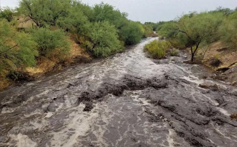
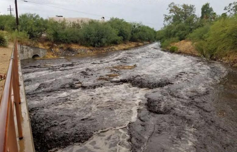
That wash already experienced flooding twice in a little more than a week’s time. It came in the form of black gunk from the burned areas, carrying ash, water, tree branches, twigs and other debris downstream.
On July 15, that potentially toxic mix ran 28 miles downhill in the CDO to the Santa Cruz. That came after the watershed on Mount Lemmon that feeds the wash got .83 of an inch of rain in less than an hour, Huckelberry wrote.
On Thursday, the gunk flowed again, after 1.6 inches fell over the previous 12 hours at the top of its watershed on Dan Saddle, just north of Summerhaven. In the same period, 1.2 inches fell on Samaniego Peak along the Catalina Mountains’ west side, also in the CDO watershed, Orchard said.
More typically, flood discharges into major washes during a 100-year storm are now likely to be 30% to 40% above normal because of the fire. That is still significant, Huckelberry said.
Of 17 major washes and tributaries that county officials analyzed, the watersheds above 12 of them were at least 50% burned.
“Clearly, the 120,000-acre Bighorn Fire will have significantly more adverse flood impacts on the county than any past fires in the Santa Catalina area,” including the 84,000-acre Aspen Fire of 2003 and the 31,000-acre Bullock Fire of 2002, Huckelberry wrote.
Pima Wash also of particular concern
It’s tough to say how many washes could be overtopped during a major storm, Shepp said. But since a normal, natural wash channel can’t hold a 100-year flood, floodwaters theoretically could rise over any of these natural washes in such a storm, he said.
Pima Wash is another wash of particular concern to county officials, because computer models of a 100-year storm show that a portion of the wash’s flows would be diverted at Ina Road directly onto the road, said Eric Shepp, the flood control district’s deputy director.
Other areas newly at risk are land parcels along the Esperero Wash on the northeast side and washes draining from Pusch Ridge toward Oro Valley, Shields wrote.
The reason more areas are now considered at risk for flooding is that the initial estimate was based only on homes in the Pusch Ridge area, and Pima Canyon, Geronimo Wash and Finger Rock and Sabino canyons, said Orchard and Shepp.
The second round of letters went to people along the Cañada del Oro, Sabino Canyon and Sutherland Wash, as well as numerous properties in Oro Valley along tributaries to the Cañada del Oro, Shepp said.
“New rain gauges were just installed in Pima and Ventana canyons to assist in early detection … and to provide warnings,” Shields wrote. “It should be noted that these are steep watersheds with very little time, one hour or less, from rainfall events to peak flows.”
Photos, maps show the damage
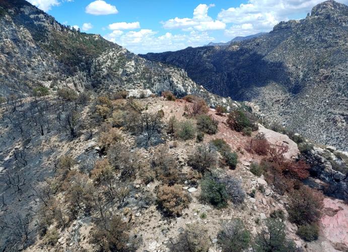
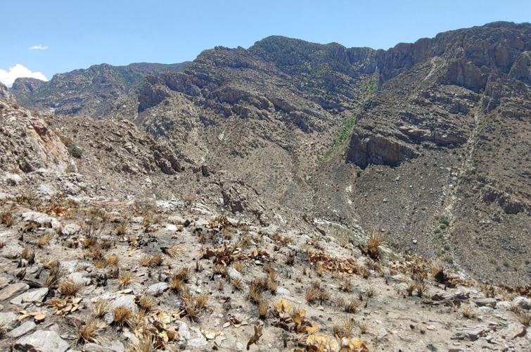
While it could be months before the general public can see up close the ecological havoc the Bighorn Fire wreaked on Mount Lemmon, photos of burned areas attached to Huckelberry’s memo are stark.
Blackened ridges. Yellow and brown trees, barren of leaves. Charred trees, looking like sticks. Mountainsides with deep brown scars.
A map devised by county flood control officials puts the damages in a different light. Deep reddish streaks show the most severely burned areas. The deep reds are particularly concentrated in the Upper Cañada del Oro watershed, but some streaks of a lighter red lie well down into the Catalinas’ front range.
Statistically, the county’s estimates of fire damage were more severe than those done earlier this month by a federal team known as the Burned Area Emergency Response Team.
The county assessment found 16% of the fire area received severe burns while another 4% was highly burned. Of the entire 119,978-acre burn area, 47% received burns of at least moderate intensity, the county concluded.
How the burn affects runoff potential
In the most highly burned areas, the soil structure is weakened, and fine roots in the soil are consumed, said Dorilis Camacho Torres, a U.S. Forest Service spokeswoman.
The charred soil is unable to absorb stormwaters, intensifying runoff, county officials say, a problem aggravated by the fire’s destruction of trees and shrubs. Then, ash, mud and vegetation debris will flow down a wash downhill of the burned area.
“That means even light rain can potentially turn into a financially devastating flash flood, or mudflow and can occur with very little warning,” the flood control district said on its website.
A video of a 2011 fire-driven flood cruising past and overrunning a northern New Mexico apple orchard is one particularly bad example cited by Pima County flood officials of what can happen. A less overpowering, ash-filled flow coming down the Cañada del Oro was captured on video on July 15 of this year.
Both the county’s and the federal maps show the brightest and deepest red, indicating most severely burned areas, on Mount Lemmon’s north side, areas that feed into the Cañada del Oro.
The areas closer to Summerhaven, the observatory and radio repeater towers on the mountain were not burned as badly, because “fire suppression activities used multiple strategies” to prevent fires from getting there, Torres said.
The most severely burned areas also were subject to more intense fire behavior driven by fuels, weather and topography, Torres said. Adding to the intensity “was the comprehensive and compounding nature of wildfire when it aligns with slope” on a mountain.
In the most severely burned soils, the soil structure is noticeably weakened, she said. Depending on how hot the surface got during the fire, the soil color can change, typically becoming reddish or orange.
The soil profile’s roots are also charred or consumed, she said. In such areas, rainfall “beads up,” forming the shape of a bead or coming together in droplets instead of being absorbed by soil. Water can also be repelled in moderately burned areas.
The result, Huckelberry warns, will be a “dramatic increase in stormwater and flood flows.”


