


About 115 people listened to the Arizona Department of Transportation’s plan to connect Interstate 10 and Interstate 19 south of the Tucson International Airport Thursday night, but some attendees left with more questions than answers about the project’s specific impacts.
While the plan is in its preliminary phase, officials presented three recommended routes, narrowed from 10 in September, for visitors to ask questions about during the public forum.
ADOT says the project is an important step in preparing for an expected boost in population. The department projects population to rise from the current 1 million to 1.4 million people, along with job growth from 400,000 to 600,000, in the Tucson metropolitan region by 2045.
The funding for the $3.5-million study came from the Pima Association of Governments, the designated metropolitan planning organization for the county.
In the study, ADOT used six criteria when narrowing down the proposed routes: anticipated growth, mobility, system linkages, economic development, environment and implementation feasibility.
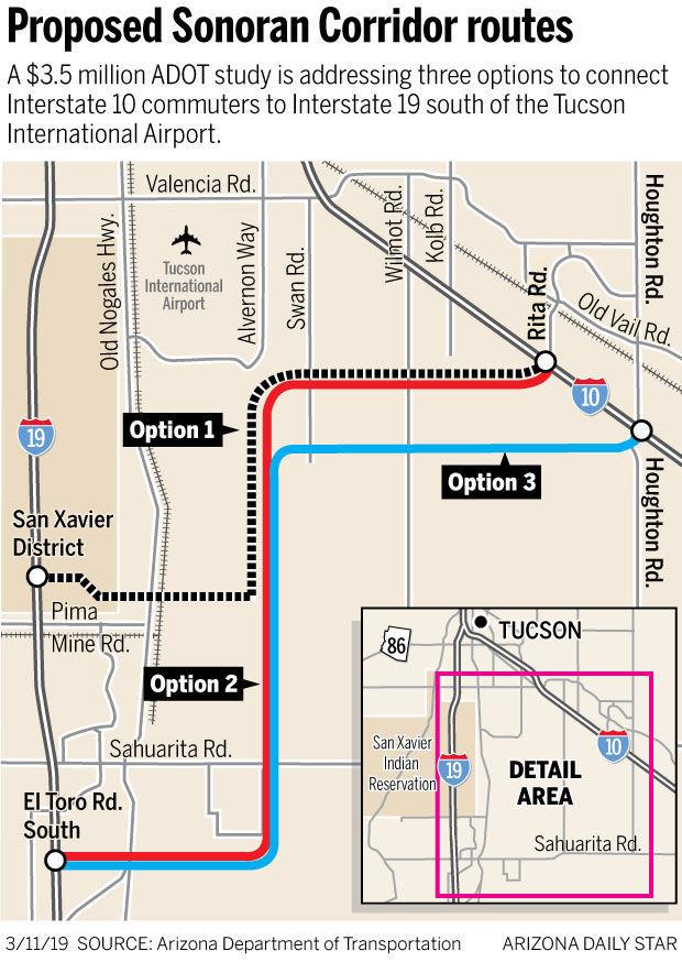
Option 1: Rita Road to San Xavier District
This route would snake from Rita Road southwest to the San Xavier District where it would connect to an on-ramp of I-19. The proposed endpoint would be on Tohono O’odham land, meaning ADOT would first need the tribe’s support and approval before construction.
The route scored highest on being able to handle the population growth, the ability to reduce travel times and economic impact by bringing motorists to jobs along the corridor, ADOT says. It’s lowest score was mobility, which adds difficulty when trying to improve traffic operations to meet projections for 2045.
“To me, the most important thing is to impact as few people as possible,” said Marcus Xavier, who works in the Rita Ranch area.
“I’ll take an environmental hit, I’ll take a longer commute, I’ll take less economic growth later if we’re not kicking people out of their homes, but I want the road to get built. I think it’s a good idea.”

Tremaine Wilson with the Federal Highway Administration talks about the Sonoran Corridor during a public meeting in Tucson on March 7, 2019.
Option 2: Rita Road to El Toro Road South
This route extends southwest from Rita Road but continues farther south to El Toro Road South, near Sahuarita Road, before connecting to I-19.
It scored highest for reducing commuter travel times, in economic benefit with serving businesses and would be easiest to implement when it comes to acquiring property. It’s lowest score was on environmental impacts.
ADOT says it may impact sensitive species of animals and disadvantaged populations.
“It’s going to be difficult when they have not assessed the impact on homeowners as part of Tier 1,” said Katherine Wade, who lives near El Toro Road South, an area along two of the routes.
“I know it’s farther out of the way, but there’s Sahuarita Road, there’s Wilmot, there’s other ways to get there. Why do we need a multi-million dollar project if there’s already methods in the area?” she asked.
Option 3: Houghton Road to El Toro Road South
Motorists would travel from Houghton Road to El Toro Road South along a similar path to Rita Road, according to ADOT’s map.
The route scored highest when it comes to linking drivers to other highways and roads, economic benefits and would provide fewer construction challenges. The route scored lowest on environmental impacts.
Darrell Livingston, a resident living near Houghton Road and Old Spanish Trail, said the project would provide a useful connection.
“We’ve only got one freeway, two counting I-19, this would connect the (region),” Livingston said.
“They’re going to improve a lot of these roads out here and that would be great access for the whole area.”
Next steps
Once officials finalize the Tier 1 study portion by spring 2020, they’ll advance to the Tier 2 environmental studies.
ADOT and the Federal Highway Administration will examine each section of the selected corridor route in greater detail, such as impacts to intersections and on-and-off ramps.
While more specifics are needed, Thursday’s public event was an important step in continuing dialogue with the community.
Let ADOT know about the recommended routes
If you didn’t make it to last week’s meeting or thought of something to add, you can leave your opinions at tucne.ws/15mx
For more information about the project, visit the ADOT website at azdot.gov/SonoranCorridor
Photos: Nogales road trip in 1956
Roadtrip to Nogales
Updated
Driving on south on Old Nogales Highway in July, 1956. Don't do this at home. Photo by Preston Yeager / Tucson Citizen
Roadtrip to Nogales
Updated
Highway sign on Old Nogales Highway south of Tucson in July, 1956. Photo by Preston Yeager / Tucson Citizen
Roadtrip to Nogales
Updated
Sign warming of dangers on Old Nogales Highway south of Tucson in July, 1956. Photo by Preston Yeager / Tucson Citizen
Roadtrip to Nogales
Updated
Old Nogales Highway at night, approaching Sahuarita in July, 1956. Don't blink. Photo by Preston Yeager / Tucson Citizen
Roadtrip to Nogales
Updated
Nogales, Sonora, bars in July, 1956. Photo by Preston Yeager / Tucson Citizen
Roadtrip to Nogales
Updated
Nogales, Sonora, bars in July, 1956. Photo by Preston Yeager / Tucson Citizen
Roadtrip to Nogales
Updated
Moody beer bottles and glasses in a Nogales, Sonora, bar in July, 1956. Photo by Preston Yeager / Tucson Citizen
Roadtrip to Nogales
Updated
Dancing at a bar in Nogales, Sonora, in July, 1956. Photo by Preston Yeager / Tucson Citizen
Roadtrip to Nogales
Updated
A bartender in Nogales, Sonora, pours salt on his hand prior to a shot of tequila in July, 1956. Photo by Preston Yeager / Tucson Citizen
Roadtrip to Nogales
Updated
Old Nogales Highway in July, 1956. Martha, are we near Mexico? Photo by Preston Yeager / Tucson Citizen
Roadtrip to Nogales
Updated
Old Nogales Highway near Ruby Road in July, 1956. Photo by Preston Yeager / Tucson Citizen
Roadtrip to Nogales
Updated
Old Nogales Highway in July, 1956. Watch out for the highway patrol. Photo by Preston Yeager / Tucson Citizen

