


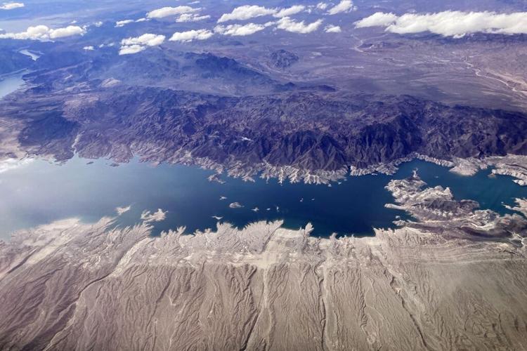

Lakes Powell and Mead, the depleted symbols of the Colorado River’s water crisis, are unlikely to ever fill again, several water experts say.
This year’s extremely heavy snowpack in the river’s Upper Basin states will produce the river’s second highest annual flow of the 21st century, federal forecasts show. The river is expected to bring 18.6 million acre-feet of water to Lee’s Ferry, lying between Glen Canyon Dam and the Grand Canyon in northern Arizona, the U.S. Bureau of Reclamation predicts.
The flow is likely to be 80% to 140% greater than the river has carried in any of the previous three years, federal records show.
But given the reservoirs’ precarious conditions, with both carrying 25% to 30% of their capacity today, it would take another four or five consecutive years of high flows like this one to fill Powell and Mead again, said Brad Udall, a Colorado State University climate scientist, and Eric Kuhn, a water researcher and former general manager of the Colorado River Water Conservation District in Glenwood Springs, Colo.
That’s highly unlikely or impossible, with the river carrying about 20% less water, on average, each year than it did during the 20th century, Udall and Kuhn said.
“We’re in a century with extreme climate change that is reducing flows in most years due to human-caused increases in heat,” Udall said.
Officials in Reclamation’s Upper and Lower Basin offices didn’t respond to questions from the Star about whether they agree with Udall and Kuhn’s gloomy outlook for the lakes.
But at a federally sponsored webinar held Tuesday, May 9, Paul Miller, a hydrologist for the federal Colorado River Basin Forecast Center, said he believes it could take even six to eight years like this one to refill all the reservoirs in the river’s Upper Colorado River Basin, plus Lake Mead in the Lower Colorado River Basin — “which probably isn’t very likely.”
Miller noted that Jennifer Pitt, a longtime Colorado River activist for the National Audubon Society, has recently concluded that “if we had normal snowpack conditions for three straight years and also zero water use, we’d refill the majority of the Upper Colorado Basin reservoirs.” Miller based his six- to eight-year estimate on Pitt’s logic, but “knowing we are not ever going to not use water.”
The webinar was sponsored by the National integrated Drought Information System, a branch of the National Oceanic and Atmospherics Administration. A second speaker, Andrew Hoell, a research meteorologist for NOAA’s physical sciences laboratory, said Miller’s “back of the envelope calculations” are realistic.
While the lack of soil moisture due to hot, dry springs and summers has repeatedly held down runoff into Lake Powell in recent years, this year, “Things are copacetic now. They’re great,” Hoell said.
“The snow is going to run off and replenish the soil moisture. But it will take longer for reservoirs to recharge. They need the sustained behavior for many years. We need to go into a wet regime to refill those reservoirs.”
Cutting water use
The reservoirs are in bad enough shape that the bureau is studying two alternatives for curbing consumption of river water by the Lower Basin states of Arizona, California and Nevada by 2 million to 4 million acre-feet a year. Such a cut, starting next year, would be equivalent to up to nearly 30% of current levels of use.
Such reductions are needed to insure the lakes don’t fall so low that their dams can no longer generate electricity, let alone to “dead pool,” in which no water could be extracted from them, bureau officials have said.
The bureau is expected to announce a final decision on cuts by August. Arizona and the six other river basin states’ water officials are trying to negotiate their own agreement to avoid taking more draconian, federally imposed reductions.
But the reservoirs’ situation may not be hopeless even if they don’t refill. Even in today’s drier climate, it’s still possible the river could get enough consecutive years of better than average flows — as occurred during the late 1990s — to give the Colorado a breather and stave off drastic cuts for awhile, Kuhn and Udall said. While such a string of wet weather years wouldn’t fill the lakes, they would lift their levels to at least half full.
The river carried 21.6, 16.6 and 15.8 million acre-feet a year, respectively, from 1997 through 1999. All three flows were well above the Colorado’s average, annual natural flow of 15 million acre-feet during the 1900s — an average that has fallen sharply since then. Since 2000, the Colorado has never had even two consecutive years of above-normal flows, federal records show.
“Maybe that would not completely fill the reservoirs, but it would certainly give us plenty of maneuvering room,” Kuhn said.
While agreeing with Kuhn, Udall added, “I’ve always said that we could get a string of wet years but that the overall aridification trend in the long run means it will get hotter and drier over time. Not every year will be hotter and not every year will be drier, but that’s our future.”
But even if the river had three wet years combined with 4 million acre-feet annually in water use curbs, that would still not refill the reservoirs entirely, he said.
“More importantly, I cannot envision any set of circumstances ever where once these reservoirs went to half full that anyone would want to endure the pain of 4 million acre-feet a year cuts,” Udall said. “Historically, this whole system has been designed to push out as much water as possible every year.”
Pattern: Dry years after wet ones
The last time the Colorado had four lush years in a row was also the last time both reservoirs filled: 1983 through 1986.
In those years, the river regularly experienced flooding, sometimes very serious. Between 21 million to 24 million acre-feet a year poured through Lee’s Ferry, a natural corridor between Utah and Arizona where the federal government measures river flows.
That’s more water than all the Colorado’s 13 major reservoirs are storing today. The last time Powell and Mead came even close to filling was in 1999.
The mid-’80s were part of an unusually wet era on the river that stretched from the late 1970s to the late 1990s. Since then, the Colorado River Basin, along with the entire Southwest, has suffered through its worst drought in 1,200 years.
“Considering the magnitude of the 20th century flows . . . the unprecedented warmth since the 1970s, the repeated low flows since 2000, and additional certain warmth going forward due to continuing massive greenhouse gas emissions, the only possible conclusion is that a system refill is exceedingly unlikely,” said Udall. Son of the late, longtime U.S. Rep. Mo Udall of Tucson, he has been at the forefront of scientists warning about risks to the river from climate change since the early 2000s.
Lake Powell in early May stood 25% full, at about 3,525 feet. At the same time, Mead stood at 29% full, at 1,049 feet elevation.
Udall noted that over the past decade or so, a pattern has developed in which very wet years in 2011, 2017 and 2019 were followed by one or more very dry years.
In fact, 2018 had the lowest precipitation across the river’s Upper Basin of any year since 1895, when records started being kept. The 23-year period ending in 2022 also had the lowest 23-year average precipitation on record, he said.
“Yes, climate change can provide very wet years like this year — and we should expect these years — but they will not make up for the more frequent hot and dry intervening years,” Udall said.
Kuhn noted that many forecasters are already predicting that the upcoming winter of 2023-24 will be an El Niño winter, in which the Southwest gets unusually heavy rains and in which the Colorado’s Upper Basin can but doesn’t always get unusually heavy winter precipitation. The Upper Basin states include Colorado, New Mexico, Utah and Wyoming.
“If 2023-24 is indeed a strong El Niño, I would not rule out a three-year wet period similar to 1997 ,’98, and ‘99,” he said. “Of course, there is no guarantee that we’ll actually have a strong El Niño or that if we have one, it will be a wet year.”
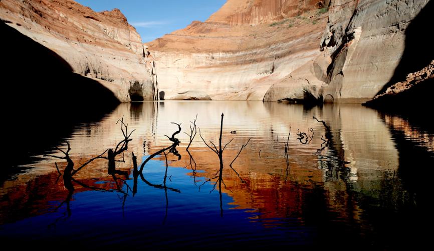
Photos: The receding waters of Lake Powell, Glen Canyon National Recreation Area

Tom Wright hikes past the beached marker for Willow Canyon where it joins with the Escalante River, Glen Canyon National Recreation Area, Utah.

A big horn sheep stands with the moon as a backdrop, looking over Fiftymile Creek, Glen Canyon National Recreation Area, Utah.
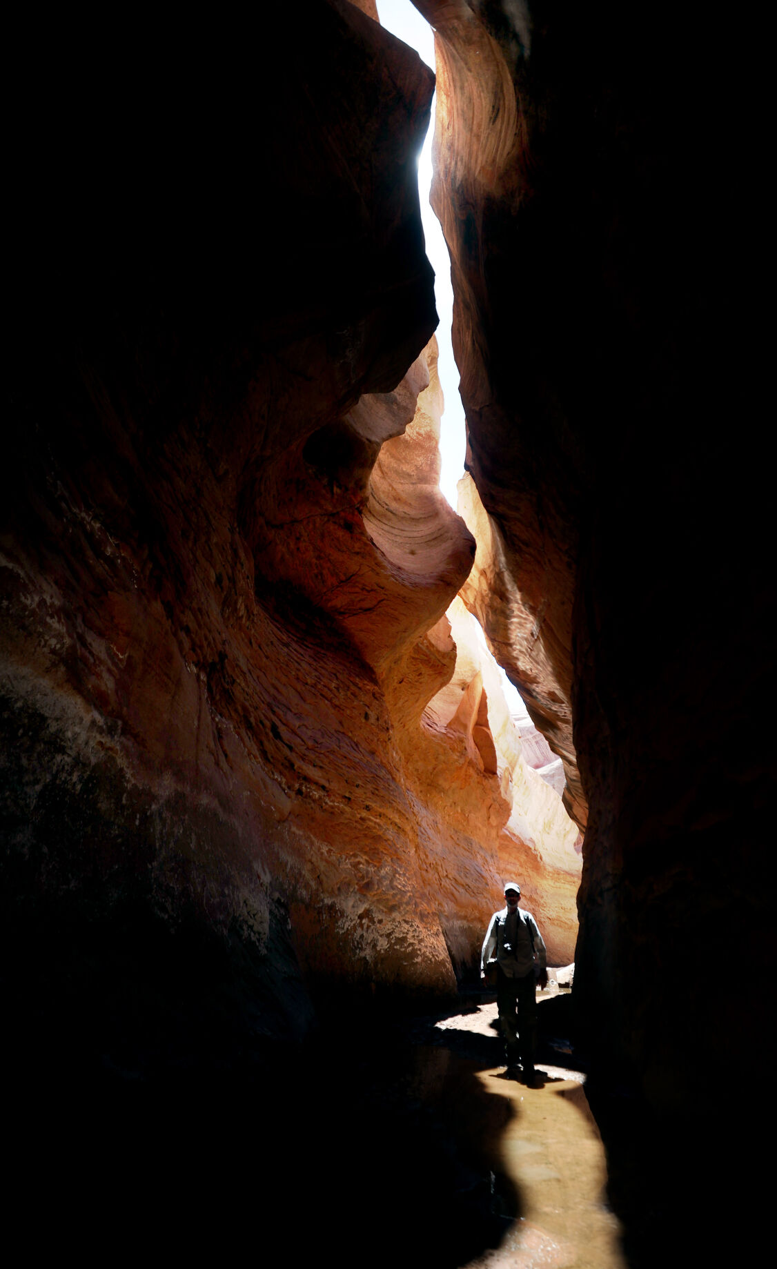
Tom Wright walks through the shaft of light peeking through the narrow openings of the formation called the Subway in Fiftymile Creek, accessible since the waters of Lake Powell have fallen dramatically.

A narrow sliver of sky is visible overhead through the narrow opening of the formation called the Subway, Fiftymile Creek, accessible since the waters of Lake Powell have fallen dramatically.

The dark streaking, called Desert Varnish, is from the seepage of oxidation in the rocks, and is beginning to erase the "bathtub ring", the lighter colored marks left by the waters of Lake Powell on canyon walls, Fiftymile Creek, Glen Canyon National Recreation Area, Utah.

The remains of a small boat, underwater for years, reemerges due to receding water levels of Lake Powell in the Glen Canyon National Recreation Area, Utah.
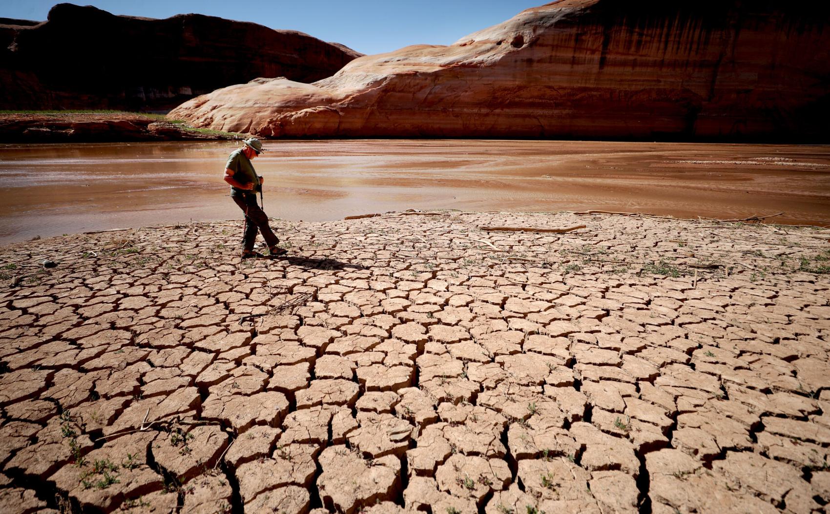
Frank Colver makes his way over the dried and cracking silt left where the Escalante River joins Lake Powell, Glen Canyon National Recreation Area, Utah. The receding water of the lake has the river cutting through the decades of accumulated silt to form a delta where it meets the lake.

A warning buoy sits high and dry far from the end of the closed public boat ramp at Bullfrog Bay, Glen Canyon National Recreation Area.

A line of tires that were once breakwaters at Bullfrog Bay Marina are now stranded on the rocky landscape high above the current water levels at the Glen Canyon National Recreation Area, Utah.
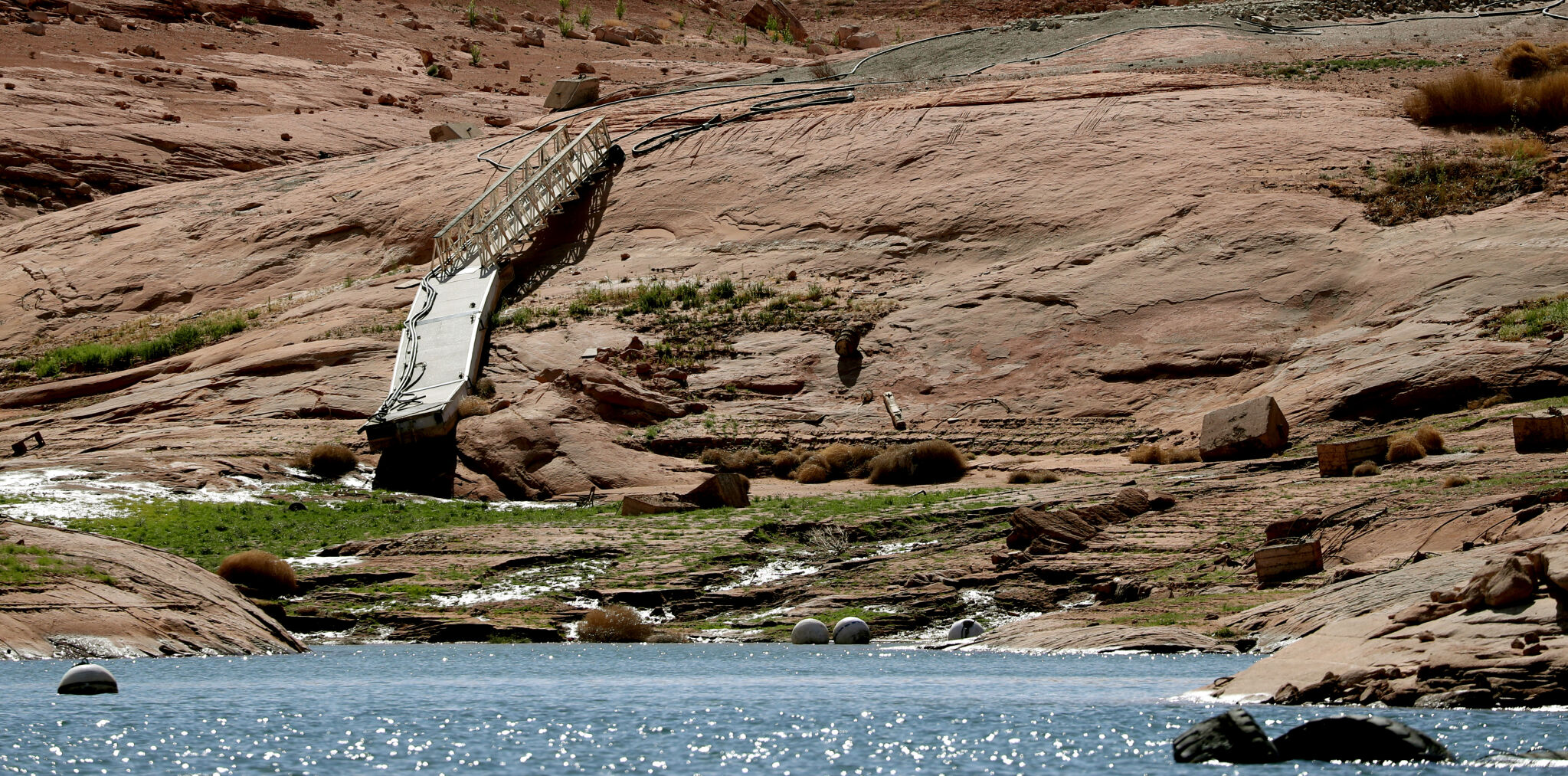
A pedestrian ramp lies well above the water levels at Bullfrog Bay in the Glen Canyon National Recreation Area, Utah.

A stranded wakeless zone buoy sits on the cracking silt outside the new shores of the Bullfrog Bay Marina, Glen Canyon National Recreation Area, Utah.

The end of the ferry ramp ends well short of the new water levels of Bullfrog Bay on the Glen Canyon National Recreation Area, Utah.

An early riser watches the sun come over the low waters of Bullfrog Bay Marina, Glen Canyon National Recreation Aria, Utah. The lighter colored areas on the canyon wall mark previous water levels.

A group of river rafters drift west on the current of the San Juan River outside Mexican Hat. The San Juan feeds Lake Powell.

The tops of a few cottonwood trees begin to poke out of shrunken water of Lake Powell, Fiftymile Creek, Glen Canyon National Recreation Area, Utah.

The remaining large water craft and house boats are crowded together in one of the last areas of water deep enough to support them at Wahweap Mariana, Glen Canyon National Recreation Area, Page, Ariz.

The waters of Lake Powell are twenty to thirty feet below the end of the public boat ramp at Wahweap Mariana, Glen Canyon National Recreation Area, Page, Ariz. Personal non-powered craft still use the ramp to unload, but must be carried up and down the banks to reach the water.

A view north from the Wahweap Marina Overlook show the shrunken waters around the marina in Glen Canyon National Recreation Area, Page, Ariz.

The underside of Gregory Natural Bridge, passable for the first time in almost 50 years, over the Fiftymile Creek, Glen Canyon National Recreation Area, Utah.

The moon rises over Gregory Natural Bridge, passable for the first time in almost 50 years, over the Fiftymile Creek, Glen Canyon National Recreation Area, Utah.

The exposed penstocks (intakes to the power turbines) on Glen Canyon Dam in the Glen Canyon National Recreation Area, Page, Ariz. The water level is at its lowest since 1967, when the dam was still being initially filled.

A group of sightseers get a look at the Glen Canyon Dam during a boat tour of Lake Powell, Glen Canyon National Recreation Area, Page, Ariz.

A small fishing boat ties up on the breakwater just outside the intakes for the Glen Canyon Dam, Glen Canyon National Recreation Area, Page, Ariz.. The penstocks (water intakes to the power turbines) are revealed for the first time since 1967 when the Lake Powell was being filled.

Swimmers and bathers use the jagged shores of the newly exposed banks of Lake Powell just above the Glen Canyon Dam, Glen Canyon National Recreation Area, Page, Ariz.

The Glen Canyon Bridge lies in front of electrical towers with feeder lines rising from the hydroelectric plant in the Glen Canyon Dam, Page, Ariz.

Glen Canyon Dam from Glen Canyon Bridge, Page, Ariz.

Small power boats on the Colorado River head upstream just below the Glen Canyon Dam, Page, Ariz.

Wade Quilter walks through the remains of cottonwood and Russian olive trees washed down and joined with silt to form a natural dam where Willow Canyon joins with the Escalante River, Glen Canyon National Recreation Area, Utah,

The remains of a big mouth bass lay in the silt just above where the Escalante River joins Lake Powell, Glen Canyon National Recreation Area, Utah.

The formation known as The Cathedral in the Desert on Clear Creek, Glen Canyon National Recreation Area, Utah. The re-emergence of the formation is drawing sightseers after being submerged for some 50 years.

Tom Wright feels the water oozing from the rocks in the formation known as Cathedral in the Desert on Clear Creek, Glen Canyon National Recreation Area, Utah. The re-emergence of the formation is drawing sightseers after being submerged for some 50 years.

Frank Colver takes a quiet moment and plays a handmade flute near the waterfall in the formation known as Cathedral in the Desert on Clear Creek, Glen Canyon National Recreation Area, Utah. The re-emergence of the formation is drawing sightseers after being submerged for some 50 years.

Jake Quilter walks down the newly cut banks of Clear Creek just outside Cathedral in the Desert, Glen Canyon National Recreation Area Utah. The sand is silt left behind by the receding waters of Lake Powell.

The tops of cottonwood trees that used to be under a hundred feet of water in Lake Powell are visible again in Clear Creek, Glen Canyon National Recreation Area, Utah. The deep water preserved the remains of the trees.

Boaters have to zig-zag through the rocks emerging due to receding waters of Lake Powell, Glen Canyon National Recreation Area, Page, Ariz.

Several images combined for a panoramic view of the Colorado River where it runs through the what once was Hite Marina in the Glen Canyon National Recreation Area, Utah.

A couple of sightseers take in the view from Hite Overlook over the Colorado River and the closed Hite Marina, Glen Canyon National Recreation Area, Utah.

Lone Rock, jutting out of the dry bed, would usually be surrounded by Lake Powell but is now well clear of the water, Glen Canyon National Recreation Area, Utah.

Tires that used to hold the lines well below the surface of Lake Powell are suspended over the water at Antelope Point Marina, Ariz.

Sightseers twenty or thirty feet above get photos of the low water levels of Lake Powell from the public boat ramp at Antelope Point Marina, Ariz.

The pedestrian access ramp ends abruptly twenty feet over the new Lake Powell surface at Antelope Point Marina, Ariz.

The entrance to the pedestrian access ramp of the Antelope Point Marina is taped off after being cutoff from the docks due to receding waters of Lake Powell.
Longtime Arizona Daily Star reporter Tony Davis explains what "dead pool" means as water levels shrink along the Colorado River.

