


A new proposal from California officials to cut Colorado River water use puts by far the largest potential burden on Arizona.
The proposal is similar to one advanced by the other six Colorado River Basin states in that it proposes almost 2 million acre-feet in new reductions in river water deliveries to the Lower Basin states of Arizona, California and Nevada.
But while the six-state proposal would require California to take more than 50% of the new cuts, the California proposal could end up having Arizona and Nevada take up to 80% of the cuts. Arizona would take most of those, because Arizona owns 90% of the Colorado River water rights in the Lower Basin that doesn’t belong to California.
The largest possible cuts envisioned by California could theoretically strip all supplies from the Central Arizona Project canal system serving river water to the Tucson and Phoenix areas. But California officials insist it’s not their intent to shut down the CAP because even the biggest cut would leave Arizona enough water to satisfy essential, as yet undefined, “public health and safety” needs.
The proposals, both released this week, are headed to the U.S. Bureau of Reclamation. The agency must decide by August how much to curtail river water deliveries.
Its officials have said major cuts are needed to keep Lakes Mead and Powell from falling so low they won’t be able to generate electricity or, in the worst case, be able to deliver most of the water that the Lower Basin states count on getting for drinking and irrigating farmland. The bureau will propose and adopt alternatives through publication of draft and final environmental impact statements this spring and summer.
1968 law favors California
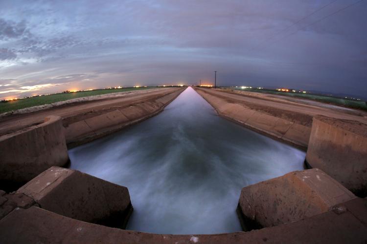
Both proposals would conserve what amounts to the bottom end of the cuts Reclamation has demanded — 2 million to 4 million acre-feet in new annual reductions. An acre-foot of water is enough to serve four Tucson households for a year, and CAP currently delivers about a million acre-feet a year.
Both say they would conserve, in total, well over 3 million acre-feet. But those totals include other conservation commitments that the states made under two previous agreements. One is a 2017 set of operating guidelines for the river’s reservoirs. The other is from a 2019 drought contingency plan.
Both proposals would also seek to insure Lake Mead doesn’t fall below 1,000 feet and Lake Powell doesn’t fall below 3,500 feet. Those levels are 50 and 10 feet, respectively, above the levels at which Hoover and Glen Canyon dams would no longer be able to produce electricity for sale to 13 million people across the basin. Both proposals also ask that the bureau use computer models to determine how their proposed cuts would affect reservoir levels, river flows and the environment in general.
But California’s proposal leans heavily on the dictates of a 1968 law that requires CAP to give up all of its water during future river water shortages before California would lose any of its water.
Arizona agreed to that provision back then to gain California’s support for the law, which authorized construction of the 336-mile CAP canal system from Lake Havasu at the river to Phoenix and Tucson.
Longtime Arizona Daily Star reporter Tony Davis talks about the Colorado River system being "on the edge of collapse" and what it could mean for Arizona.
The six-state proposal, by contrast, would base the vast majority of its cuts on each state’s relative responsibility for evaporation and other “system losses” of river water such as seepage into the ground. Since those states’ analysis — done specifically by the Southern Nevada Water Authority — says California causes by far the largest share of evaporation, their proposal gives California by far the biggest river delivery cut.
The California proposal came from the Colorado River Board of California, which exists to protect the state’s Colorado River rights and to represent the state in interstate talks over the river.
Its proposal calls on that state to absorb 400,000 acre-feet of the first million acre-feet in cuts to deliveries to the Lower Basin from Lake Mead. Arizona would take 560,000 acre-feet of that million. Nevada would take the rest. Those cuts would take effect once the bureau approved such a proposal, as long as Lake Mead stands below 1,145 feet in elevation — a condition that’s existed for many years.
The cuts could be done voluntarily, in return for federal compensation to whichever entity takes the cuts. The cuts would become mandatory if not enough water was saved voluntarily.
But once Mead falls to or below 1,025 feet — it’s at 1,046 feet now — California’s proposal says the bureau must parcel out additional cuts. They would start at 150,000 acre-feet a year, then gradually stiffen for every additional five-foot water level decline at the reservoir. If the lake fell to or below 1,005 feet, the states would have to swallow a total of 950,000 acre-feet of annual cuts beyond the first million.
Those additional reductions “should be applied using existing authorities or implemented through additional voluntary compensated conservation agreements,” the proposal said, without elaborating.
But the California proposal’s wording makes it clear that “using existing authorities” means following the historic Law of the River, a collection of laws, court rulings and regulations about the river that includes the 1968 law that would knock out the CAP during major shortages.

Irrigation water gushes through control gates and along the Rockwood Canal that channels Colorado River water to produce farms in Brawley, California, on Feb. 4, 2014.
How much for AZ’s health, safety?
If the seven basin states can’t agree on a solution to the river’s problems, the bureau should “maintain existing protections to California’s water entitlements,” along with protecting river water that all three Lower Basin states have left behind in the lake and “protect public health, safety and welfare,” said the California proposal. It’s signed by J.B. Hamby, the California board’s chairman and a board member for the Imperial Irrigation District, which controls the entire basin’s largest share of river water rights.
That public health and safety phrase isn’t defined in California’s seven-page proposal.
During last year’s extreme drought in California, its State Water Project started limiting some communities to using enough water to meet public health and safety needs, and defined that figure at 55 gallons per person per day for residents. That’s far less than current water use even in the conservation-minded Tucson area, for instance,, where Tucson Water's residential customers used about 77 gallons per person daily in 2022. No number has been determined for public health and safety needs for the Colorado River Basin.
But Bill Hasencamp, Colorado River program manager for the Southern California Metropolitan Water District, told the Star the general concept of human health and safety means full use of indoor water, as efficiently as possible, including for drinking, and limited outdoor watering.
“Not enough water to maintain a large lawn, for example, but limited irrigation, for trees and certain plants. Plus, water needed for commercial and industrial use. ... We don’t have all the answers. We’re figuring it out as we go. It’s new territory. It’s uncomfortable. It’s difficult. We’re doing our best,” Hasencamp said.
As Western law has always worked, all senior priority rights in the Colorado Basin belong to agriculture — by far the biggest user of river water in California and elsewhere, noted Bart Fisher, president of the Palo Verde Irrigation District in the Blythe, California area along the river. “The law is first in use, first in right. That’s how the system works.
“What the other states are saying is, just for the Colorado River, we should abandon that law. Not for the Snake River, or the Columbia River, only the Colorado River, because it disadvantages the six states that filed their proposal,” he said. Besides Arizona and Nevada, the other states are Colorado, New Mexico, Utah and Wyoming.
They also appear to be saying, “’Never let a good crisis go to waste. Let’s take advantage of this crisis and see if we can’t get reallocation of water rights along the river,’” said Fisher, also a member of the Colorado River Board of California.
The Arizona Department of Water Resources and the CAP issued a statement replying to California’s proposal saying there are different interpretations of what the Law of the River actually means.
‘Unrealistic’ to slash CAP to zero
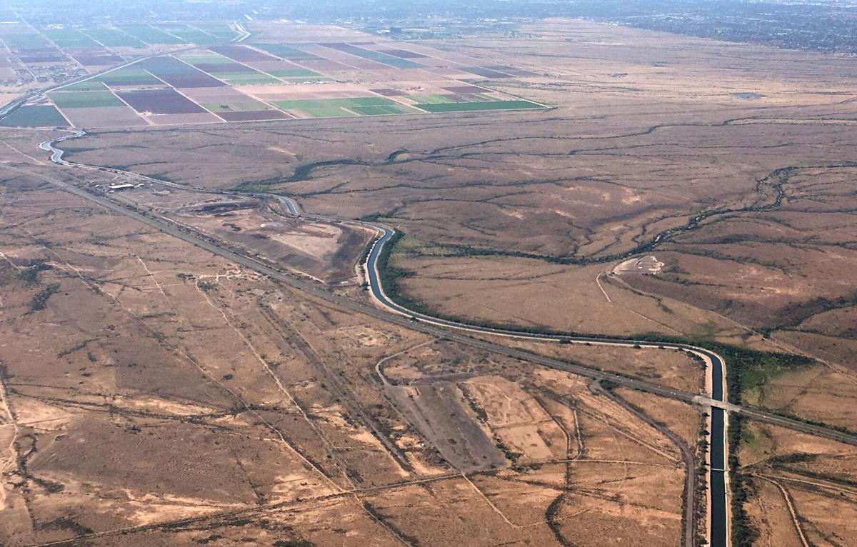
Arizona water officials have vowed to fight any proposal that would shut down CAP, a primary drinking water source for many Phoenix-area cities and virtually the only drinking water source for Tucson Water customers.
In an interview with the Star just before California released its proposal Tuesday evening, ADWR Director Tom Buschatzke declined to take on California’s legal stance, saying, “I’m not going to get into the details. Some of those are potential arguments and legal positions that can daylight in a courtroom.”
But making cuts strictly by legal priorities isn’t going to solve “the crisis that we are inside of on the Colorado River,” Buschatzke added.
“If CAP goes to zero, it’s not going to put enough water in Lake Mead to stabilize the system,” Buschatzke said. “We’re at a point, where reservoir levels are at, that the senior priority water users are going to have to find a way to agree and have reductions imposed upon them.
“There are arguments that a piece of paper gives you x, y and z (in water rights). If legal arguments don’t match physical reality, senior priority users are going to have to reduce their use somehow,” he said.
Palo Verde’s Fisher said it’s unrealistic to expect CAP would be slashed to zero water, and that California officials expect the bureau would provide Arizona enough water to meet “basic health and safety considerations for populations that need water.”
“They’re saying that for the sake of effect. But the CAP is not going to be cut off. That is just so fundamentally wrong. It’s like saying in California, let’s say the other six-state proposal prevails and L.A. and San Diego get cut off from water. That’s not going to happen,” Fisher said.
“There are population centers. They have money. They have political power. They have voters,” Fisher said.
Photos: The receding waters of Lake Powell, Glen Canyon National Recreation Area

Tom Wright hikes past the beached marker for Willow Canyon where it joins with the Escalante River, Glen Canyon National Recreation Area, Utah.

A big horn sheep stands with the moon as a backdrop, looking over Fiftymile Creek, Glen Canyon National Recreation Area, Utah.
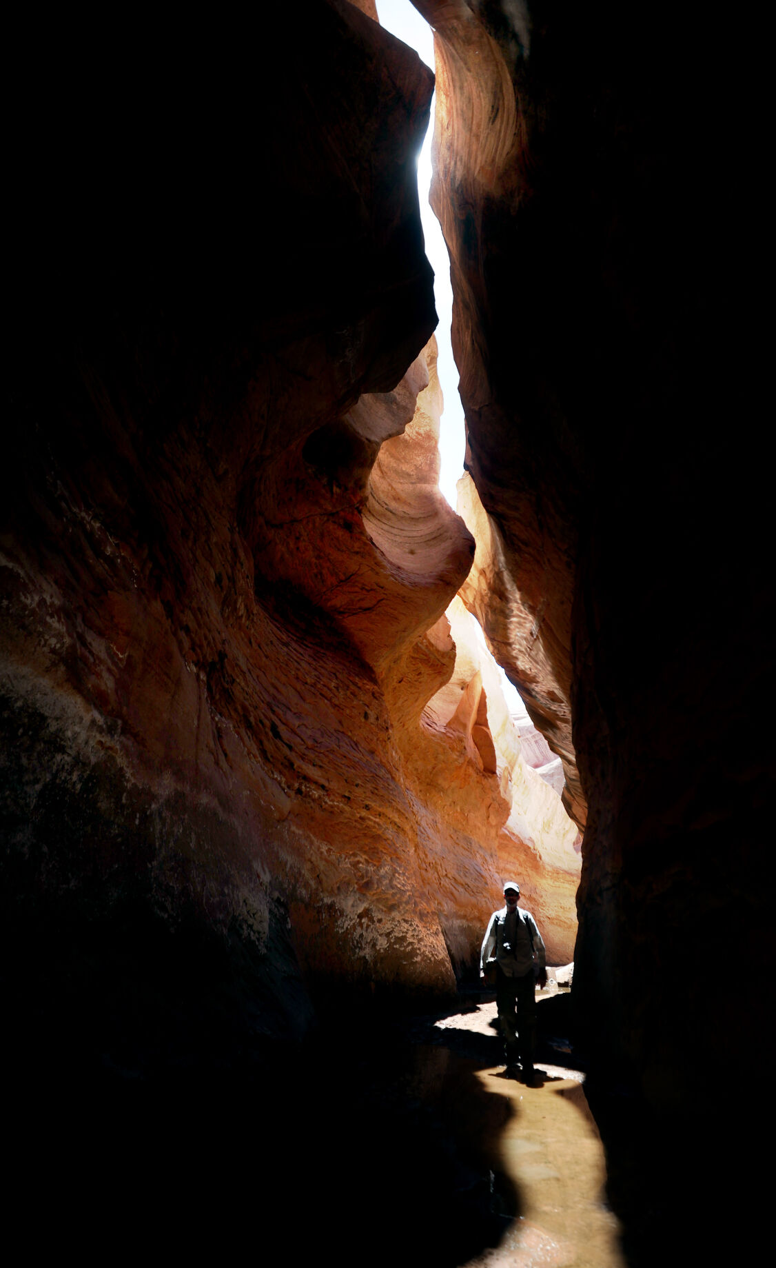
Tom Wright walks through the shaft of light peeking through the narrow openings of the formation called the Subway in Fiftymile Creek, accessible since the waters of Lake Powell have fallen dramatically.

A narrow sliver of sky is visible overhead through the narrow opening of the formation called the Subway, Fiftymile Creek, accessible since the waters of Lake Powell have fallen dramatically.

The dark streaking, called Desert Varnish, is from the seepage of oxidation in the rocks, and is beginning to erase the "bathtub ring", the lighter colored marks left by the waters of Lake Powell on canyon walls, Fiftymile Creek, Glen Canyon National Recreation Area, Utah.

The remains of a small boat, underwater for years, reemerges due to receding water levels of Lake Powell in the Glen Canyon National Recreation Area, Utah.
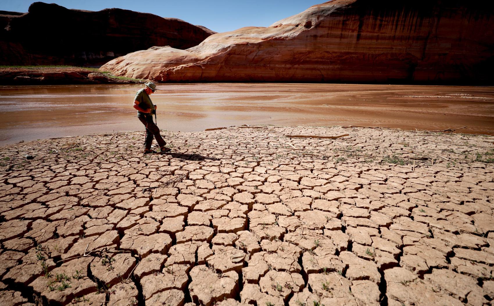
Frank Colver makes his way over the dried and cracking silt left where the Escalante River joins Lake Powell, Glen Canyon National Recreation Area, Utah. The receding water of the lake has the river cutting through the decades of accumulated silt to form a delta where it meets the lake.

A warning buoy sits high and dry far from the end of the closed public boat ramp at Bullfrog Bay, Glen Canyon National Recreation Area.

A line of tires that were once breakwaters at Bullfrog Bay Marina are now stranded on the rocky landscape high above the current water levels at the Glen Canyon National Recreation Area, Utah.
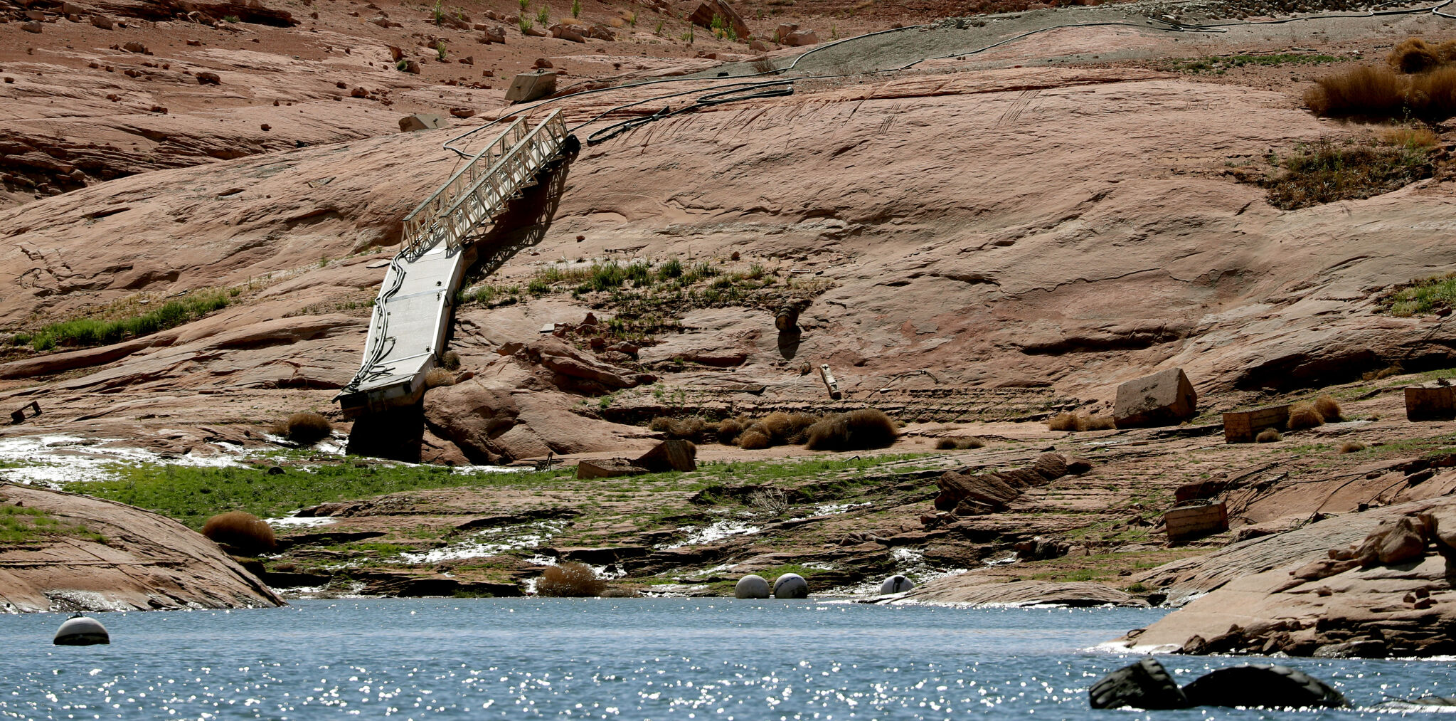
A pedestrian ramp lies well above the water levels at Bullfrog Bay in the Glen Canyon National Recreation Area, Utah.

A stranded wakeless zone buoy sits on the cracking silt outside the new shores of the Bullfrog Bay Marina, Glen Canyon National Recreation Area, Utah.

The end of the ferry ramp ends well short of the new water levels of Bullfrog Bay on the Glen Canyon National Recreation Area, Utah.

An early riser watches the sun come over the low waters of Bullfrog Bay Marina, Glen Canyon National Recreation Aria, Utah. The lighter colored areas on the canyon wall mark previous water levels.

A group of river rafters drift west on the current of the San Juan River outside Mexican Hat. The San Juan feeds Lake Powell.

The tops of a few cottonwood trees begin to poke out of shrunken water of Lake Powell, Fiftymile Creek, Glen Canyon National Recreation Area, Utah.

The remaining large water craft and house boats are crowded together in one of the last areas of water deep enough to support them at Wahweap Mariana, Glen Canyon National Recreation Area, Page, Ariz.

The waters of Lake Powell are twenty to thirty feet below the end of the public boat ramp at Wahweap Mariana, Glen Canyon National Recreation Area, Page, Ariz. Personal non-powered craft still use the ramp to unload, but must be carried up and down the banks to reach the water.

A view north from the Wahweap Marina Overlook show the shrunken waters around the marina in Glen Canyon National Recreation Area, Page, Ariz.

The underside of Gregory Natural Bridge, passable for the first time in almost 50 years, over the Fiftymile Creek, Glen Canyon National Recreation Area, Utah.

The moon rises over Gregory Natural Bridge, passable for the first time in almost 50 years, over the Fiftymile Creek, Glen Canyon National Recreation Area, Utah.

The exposed penstocks (intakes to the power turbines) on Glen Canyon Dam in the Glen Canyon National Recreation Area, Page, Ariz. The water level is at its lowest since 1967, when the dam was still being initially filled.

A group of sightseers get a look at the Glen Canyon Dam during a boat tour of Lake Powell, Glen Canyon National Recreation Area, Page, Ariz.

A small fishing boat ties up on the breakwater just outside the intakes for the Glen Canyon Dam, Glen Canyon National Recreation Area, Page, Ariz.. The penstocks (water intakes to the power turbines) are revealed for the first time since 1967 when the Lake Powell was being filled.

Swimmers and bathers use the jagged shores of the newly exposed banks of Lake Powell just above the Glen Canyon Dam, Glen Canyon National Recreation Area, Page, Ariz.

The Glen Canyon Bridge lies in front of electrical towers with feeder lines rising from the hydroelectric plant in the Glen Canyon Dam, Page, Ariz.

Glen Canyon Dam from Glen Canyon Bridge, Page, Ariz.

Small power boats on the Colorado River head upstream just below the Glen Canyon Dam, Page, Ariz.

Wade Quilter walks through the remains of cottonwood and Russian olive trees washed down and joined with silt to form a natural dam where Willow Canyon joins with the Escalante River, Glen Canyon National Recreation Area, Utah,

The remains of a big mouth bass lay in the silt just above where the Escalante River joins Lake Powell, Glen Canyon National Recreation Area, Utah.

The formation known as The Cathedral in the Desert on Clear Creek, Glen Canyon National Recreation Area, Utah. The re-emergence of the formation is drawing sightseers after being submerged for some 50 years.

Tom Wright feels the water oozing from the rocks in the formation known as Cathedral in the Desert on Clear Creek, Glen Canyon National Recreation Area, Utah. The re-emergence of the formation is drawing sightseers after being submerged for some 50 years.

Frank Colver takes a quiet moment and plays a handmade flute near the waterfall in the formation known as Cathedral in the Desert on Clear Creek, Glen Canyon National Recreation Area, Utah. The re-emergence of the formation is drawing sightseers after being submerged for some 50 years.

Jake Quilter walks down the newly cut banks of Clear Creek just outside Cathedral in the Desert, Glen Canyon National Recreation Area Utah. The sand is silt left behind by the receding waters of Lake Powell.

The tops of cottonwood trees that used to be under a hundred feet of water in Lake Powell are visible again in Clear Creek, Glen Canyon National Recreation Area, Utah. The deep water preserved the remains of the trees.

Boaters have to zig-zag through the rocks emerging due to receding waters of Lake Powell, Glen Canyon National Recreation Area, Page, Ariz.

Several images combined for a panoramic view of the Colorado River where it runs through the what once was Hite Marina in the Glen Canyon National Recreation Area, Utah.

A couple of sightseers take in the view from Hite Overlook over the Colorado River and the closed Hite Marina, Glen Canyon National Recreation Area, Utah.

Lone Rock, jutting out of the dry bed, would usually be surrounded by Lake Powell but is now well clear of the water, Glen Canyon National Recreation Area, Utah.

Tires that used to hold the lines well below the surface of Lake Powell are suspended over the water at Antelope Point Marina, Ariz.

Sightseers twenty or thirty feet above get photos of the low water levels of Lake Powell from the public boat ramp at Antelope Point Marina, Ariz.

The pedestrian access ramp ends abruptly twenty feet over the new Lake Powell surface at Antelope Point Marina, Ariz.

The entrance to the pedestrian access ramp of the Antelope Point Marina is taped off after being cutoff from the docks due to receding waters of Lake Powell.

