

A major lake-effect storm that has dumped over 6 feet of snow in Orchard Park will continue to impact the region through the weekend.
Here's what to expect. (Updated 12:45 p.m. Saturday)
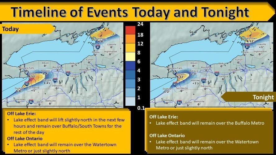
The lake-effect snow pounding the region is on the move.
A lake-effect band is starting to drift north, across Grand Island and most of Niagara County, the National Weather Service said. "This band will continue to drift north early this afternoon."
The weather service said the band is "producing extremely heavy snow at the rate of 2 to 3 inches per hour." Visibility could be reduced to less than a quarter of a mile.

"This band will continue to drift north early this afternoon," the Weather Service said.
"Travel will be extremely difficult, if not nearly impossible in the most intense portion of this band, including Niagara Falls, Lewiston, Newfane and Lockport,' the Weather Service said.

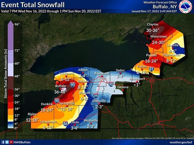
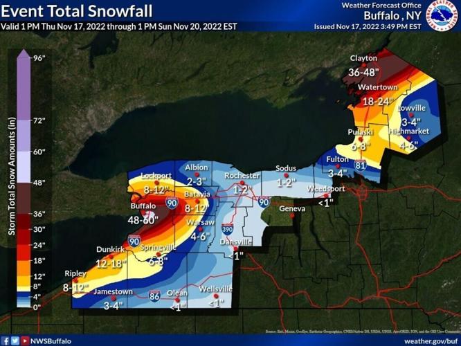
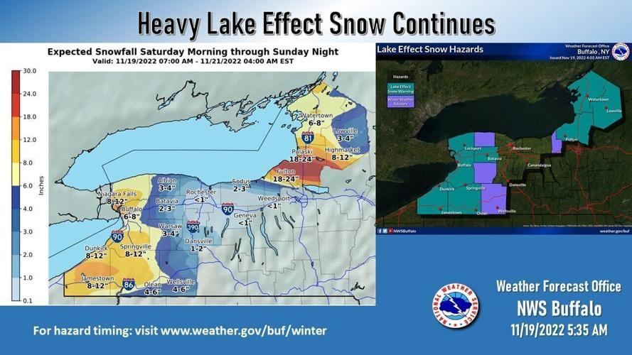
Here are the National Weather Service's updated snowfall totals.
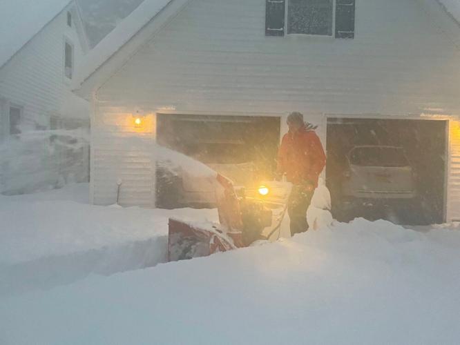
Conditions remain "extremely dangerous" in the Southtowns, according to the Erie County Department of Public Works. The department's plows are getting stuck due to hard-packed snow and ice underneath newly fallen snow, the department said in a Twitter post Friday.
"Colder air will continue to pour across the region, resulting in a heavy lake-effect snow lasting through this weekend," the weather service said.
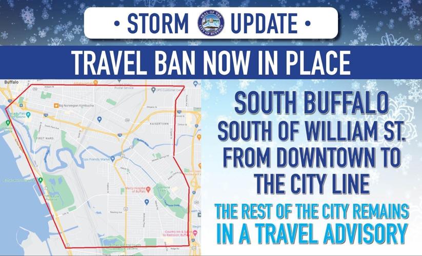
A travel ban is in effect for the entire City of Buffalo. The storm is expected to drift southward through the city on Saturday night.
At 11 a.m. Saturday, the National Weather Service posted snowfall totals of 77 inches in Orchard Park, 73.7 inches in Hamburg, and 65 inches in Blasdell.
By the time the storm ends Monday, southern Erie County could get 1 foot to 2.5 feet more. The Buffalo area will get an additional 1 to 2 feet, while Niagara County will receive 8 inches to 12 inches more, according to National Weather Service meteorologist Liz Jurkowski.
The snow closed parts of the Thruway and Routes 219 and 400, and a travel ban remains in effect for the central portion of Erie County.
Despite the ban, authorities report numerous vehicles stranded in hard-hit areas, particularly Hamburg.
Also, the Thruway is closed from Exit 53 (I-190) to Exit 59 (Dunkirk). No traffic can enter between those exits, the Thruway Authority announced in a tweet.
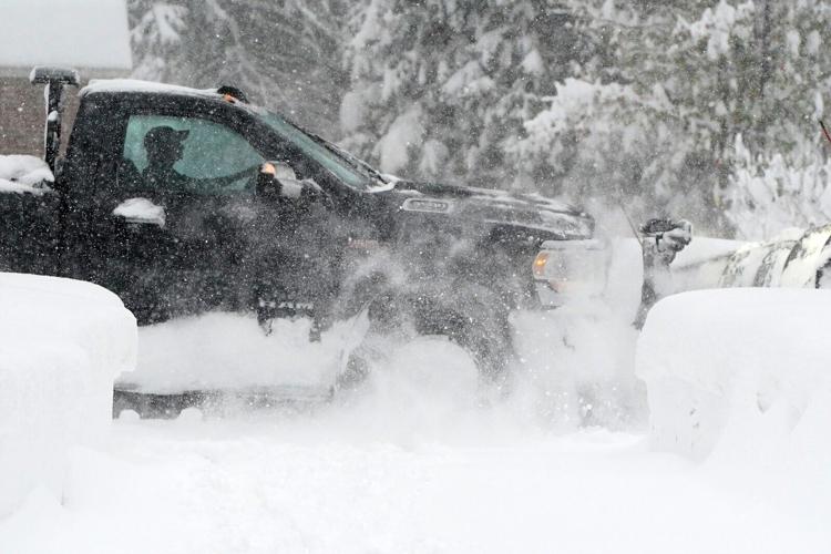
Orchard Park plows clear the streets
Here's how the storm will play out over the weekend:
Saturday
The storm will remain in northern Erie and Genesee counties, as well as Niagara County, throughout the day Saturday.
A lake-effect snow warning remains in effect until 1 p.m. Sunday in Buffalo and Batavia. It remains in effect until 7 a.m. Sunday in Niagara Falls.
The Weather Service forecasts 6 to 8 inches of additional snowfall in Buffalo through Sunday and an additional 8-12 inches in Niagara Falls.
Looking back at Buffalo's memorable November storms
Saturday night:
The storm will shift to the south overnight Saturday.
As it shifts south Saturday, it intensifies and will get back to the 1 inch to 3 inches of snow per hour, the National Weather Service has said.
“It will shift south across the Buffalo metro into the south, and get to Chautauqua County early Sunday morning,” Jurkowski said.
It also will get breezy, with gusts around 20 mph.
Sunday:
The snow band will remain across Chautauqua County and southern Erie County, and it will be breezy, with gusts up to 45 mph.
"That's going to blow some of that snow around, even if you're not in the band," Jurkowski said.
An additional 8 to 12 inches could accumulate in southern Erie County, including Springville through Sunday.
Sunday's high will be about 26.
Monday:
There's a chance of rain and snow showers Monday afternoon. It will be mostly sunny, with a high near 36.

