


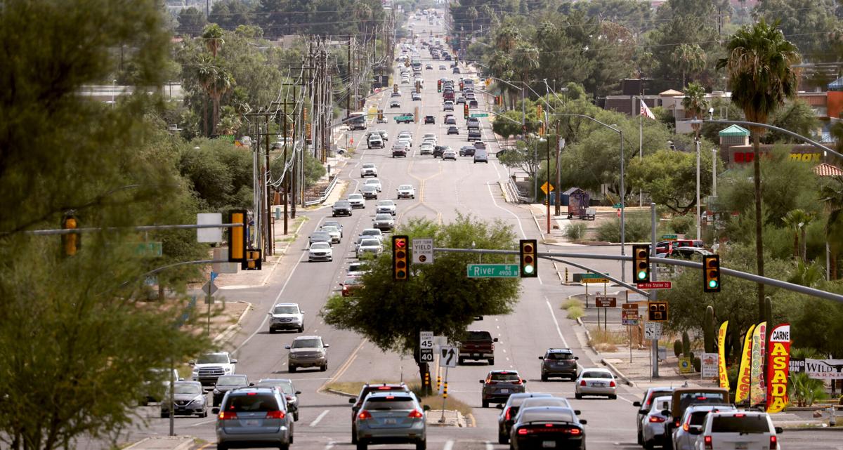
Tucson is facing another setback from the Regional Transportation Authority in a key construction project on a three-mile stretch of North First Avenue known for high numbers of pedestrian fatalities.
The renovation of First Avenue from Grant to River roads is one of the city’s projects built into the $2.1 billion RTA plan voters approved in 2006, but the city has advocated for a different version of the project than the one presented 16 years ago.
While the original ballot language called for expanding the road to six lanes, the city has since conducted a study that suggests keeping the road at four lanes with a raised median and several other safety improvements would meet current traffic projections while making the road safer for pedestrians and bicyclists.
The RTA’s Technical Management Committee tasked with overseeing the logistics of project delivery recommended the RTA Board proceed with the four-lane option and solicit more public feedback if it deems necessary. The nine-member board of representatives from Pima County’s jurisdictions and the Arizona State Transportation Board has to give final approval for the scope change on First Avenue.
The First Avenue project will instead go through the RTA’s corridor planning process to study both the four- and six-lane options that Executive Director Farhad Moghimi said could take around a year to complete.
After contracting COVID-19, Tucson Mayor Regina Romero wasn’t able to attend the RTA Board’s Dec. 8 meeting and express the city’s wishes to proceed with the design of a four-lane option.
In her absence, other RTA Board members said they want more public outreach and technical analysis before making a decision but voiced a desire to expedite the process.
“My biggest request would be — it is a road that’s of high visibility, high discussion, a lot of debate — and I think we could get through our normal process in an expedited manner,” said Gen. Ted Maxwell, the board’s Arizona State Transportation Board appointee, who also noted “I don’t think we can discount what the city’s done” in its own study.
Marana Mayor Ed Honea said, “All this stuff is being done by the city exclusively,” and that there should be more regional input on the scope reduction. Sahuarita Mayor Thomas Murphy expressed hesitation in changing the project from what voters approved in 2006.
First Avenue is scheduled to begin construction in the 2025-2026 fiscal year. But before construction starts, Tucson will have to create a design concept report for the project that typically details 30% of the conceptual design for the construction of both the four and six-lane options. Once the analysis is complete, the board will make a decision on which option to choose.
The Tucson City Council has pushed for the RTA Board to accept a four-lane option based on the study it conducted throughout early 2021. The First Avenue Needs Assessment Study found the four-lane option would be safer for pedestrians to cross while taking up less private property than a six-lane expansion would.
But Moghimi called the city’s analysis is “a completely different process” than what’s needed to initiate design, which is similar to the three-year planning process that took place before the Broadway RTA project was reduced from eight to six lanes.
The corridor planning process is required for all RTA projects, but the city worries restarting the outreach and technical study processes it already conducted will only further delay the project’s delivery.
“(The city) did a public process. If RTA wants to do an additional public process, that’s fine,” said Councilman Kevin Dahl, whose Ward 3 encompasses the First Avenue project. “They should have started in a year ago, and they should do it on their own dime. And they shouldn’t spend extra money, when we’re low on money, to duplicate something that’s been done.”
In his year as a city councilman, Dahl said he’s continuously heard concerns about safety on First Avenue. Recently, administrators from the Satori School on North First Avenue asked to meet with his staff, he said, over concerns for the safety of their students.
The corridor is part of Tucson’s pedestrian high-injury network, meaning it’s in the top 10% of corridors for pedestrian crashes in the city. Pedestrians on the road are hit twice as often as they are on nearby streets and the area averages more than 100 vehicle crashes each year, according to the city.
“Delaying and doing another study means increased deaths and injuries to people, because the safety features won’t be put in. It means increased costs, because we’re in a time of inflation and supply chain problems,” Dahl said.
The city’s lost one of its main selling points on the reduced scope as inflationary factors have compounded the project’s estimated cost. The city originally estimated the four-lane version of the project would cost about $18 million less than the six-lane version, but the project cost has increased from $73 million to an estimated $113 million.
There’s also an extra $30 million needed for drainage improvements near First Avenue before construction can begin. Those funds have yet to be identified, and the language on the RTA Board’s agenda specified “floodplain improvements aren’t eligible for RTA funding.”
The floodplain issue was a point of contention discussed at the City Council’s Dec. 6 meeting. City Manager Michael Ortega said the agenda language “makes it sound like we as the city have all this work to do, which is very disappointing to say the least,” and argued some of the drainage improvements are necessary road improvements instead of floodplain issues that would address flood control in adjacent neighborhoods.
The drainage in the roadway itself is “part of the road design and should be part of the costs,” Ortega said.
The city agreed to delay two of its RTA projects — Houghton Road from Broadway to Tanque Verde Road and 22nd Street from I-10 to Kino Parkway — to lessen the RTA’s funding shortfall but has continuously advocated for getting the First Avenue project completed in the current 20-year transportation plan.
According to Moghimi, the RTA doesn’t need to move any more projects into the next RTA to address its funding shortfall. However, the executive director previously told the City Council that any projects withscope changes and “an incremental cost increase” that Tucson doesn’t cover with its own funds would have to go back to Pima County’s voters for approval.
Whether First Avenue would have to go back to voters is “a policy decision for the Board to determine if the proposed changes are significant enough to warrant that,” Moghimi said.
Aerial photos of Tucson in 1968

Looking north from Arroyo Chico, still more or less an open pit, where it crossed S. Cherry Ave. (lower right) in this aerial photo of Tucson in December, 1968. At that time, Cherry was a popular thoroughfare, extending from 29th Street through the University of Arizona campus and past Speedway Blvd. It was cut into pieces with the expansion of Arizona Stadium, the Arroyo Chico flood control project, and the Kino Parkway extension.

The clean, straight University of Arizona Mall splits the campus in two in this aerial photo looking west from Tucson Blvd. in December, 1968. The 100-foot-tall Meinel Optcal Sciences Building is under construction on open land cleared for more expansion, in the left side of the photo.

Looking east at the West University neighborhood and the University of Arizona Campus, center, from roughly Stone Ave. in this aerial photo of Tucson in December, 1968. 6th Avenue is at the very bottom. Catalina Park is lower left.

Sahuaro High School, which opened for students in August, 1968, in the center surrounded by new subdivisions in this aerial photo southwest across Tucson in December, 1968. The one swath of open desert across the street from the high school did not stay that way for long.

Downtown Tucson with "A" Mountain and Tumamoc Hill in the distance in this aerial photo of Tucson in December, 1968. Homes and businesses in the old barrio have been razed to make way for the TCC and Symphony Hall, left. The Southern Pacific RR hospital (now Evo DeConcini U.S. District Courthouse) is in the center of the photo. The Pima County Administration building is nearly complete, but construction on the Superior Court building has not begun. Stone Avenue, at bottom, still has the large department stores – Penney's, Jacome's, Steinfeld's. But their existence was doomed by El Con Mall a few miles to the east.

Rolling Hills Golf Course and new houses around it along a two-lane (and partly dirt) Golf Links Road in this aerial photo of Tucson in December, 1968. St. Augustine Catholic High School sits on the right side in the large open plot just above the golf course. The "V" building – the only structure on the Southside of Golf Links, is still there. It's the New Life Wesleyan Church.

22nd Street stretches east from Houghton Road in Tucson in this aerial photo of Tucson in December, 1968. In the center, Old Spanish Trail crosses 22nd Street, then Harrison Road. The land surrounding that intersection is now paved over with myriad retail businesses. At least two of the homes in the foreground are still there, surrounded by packed subdivisions.

The new Interstate 10 loops through South Tucson in this aerial photo looking southeast in December, 1968. In the distance, the new interstate hooks right and connects back to Benson Highway – the old US 80. Southgate Shopping Center and the new, concrete-lined Julian Wash are at right. The black line at left is the El Paso and Southwestern RR tracks, then still in use.

And rising from the desert is the De Anza Drive-In theatre on Alvernon Way, south of 22nd Street, in this aerial photo of Tucson in December, 1968. To the left, across Alvernon and barely visible, is the Magic Carpet Slide. In the background, the Bermuda grass at Randolph golf course at Reid Park has gone dormant for the winter.
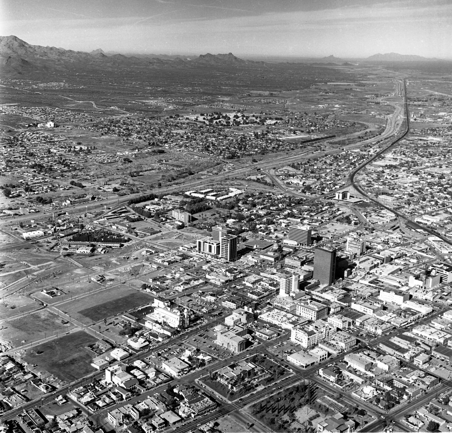
The shades of the future mesh with Tucson's past in this aerial photo of downtown Tucson in December, 1968. The new Interstate 10 is largely complete, with bridged crossings over Tucson streets. The bulldozed barrio is obvious (at left), but there are still remnants of Tucson's architectural pride: The Carnegie Library (foreground center) is beautiful, the majestic Hotel Santa Rita to its right, and several modest, quirky hotels, theaters and brick buildings with character.

Broadway Road looking west from Swan Road, Tucson, in 1968. The wide Venice Stravenue is the street visible in foreground. The Midstar Plaza is at left. The mid-rise office building at 4400 E. Broadway is under construction, just above the plaza in the photo.
The Downtown Links Project in Tucson will be a 4-lane road that parallels the Union Pacific Railroad and connects Barraza-Aviation Parkway at Broadway Road to Interstate 10 via St. Mary's Road. The expected completion date is early 2023. Video by: Mamta Popat / Arizona Daily Star (2020)

