


On Wednesday, Dec. 15, U.S. Bureau of Reclamation officials and the three Colorado River Lower Basin states — Arizona, Nevada and California — will announce their approval of a new plan to save an extra 500,000 acre-feet of river water to prop up ailing Lake Mead.
At the same time, however, a leading Colorado River researcher is warning that the new plan won’t go far enough. Researcher Kevin Wheeler says the three states will ultimately need to save at least twice the water that's going to be saved through the new plan and through the formal river shortage that will start in 2022 -- and at a faster pace than authorities now plan to do it.
Plan approval will trigger almost as much water savings as the 520,000 acre-feet of river water that Arizona and Nevada are scheduled to start conserving in 2022 under the separate 2019 drought contingency plan. The latest plan is also scheduled to take effect next year, and to last at least two years.
The announcement is due to be made at the annual Colorado River Water Users Association conference, in Las Vegas.
Just like the 2019 drought plan, the latest agreement will rely on significant cuts in deliveries to the Central Arizona Project, which brings river water via canals to tribes, farms and the Phoenix and Tucson areas. But unlike the earlier plan, this one likely won’t involve any water cuts for Tucson Water, the CAP’s largest municipal user.
The new 500,000 acre-foot savings also will be the equivalent of a bit more than one-third of what the three Lower Basin states have already agreed to save under the entire seven-year term of the 2019 drought contingency plan if Lake Mead were to drop below 1,025 feet, from its current elevation of about 1,065 feet. If Mead got that low, the 2019 plan would require the three states to conserve a total of about 1.475 million acre-feet.
But Wheeler, a lead researcher from a Utah State University team that published a groundbreaking study on the river in February, warns that a total of at least 2 million acre-feet of Lower Basin conservation will be needed to stabilize the combined reservoir storage of Lake Mead and Lake Powell.
If the “millennium drought” that began in 2000 persists, the 1 million acre-feet of conservation now approved or on the verge of approval won’t be enough, Wheeler said in an interview.
Worse, if river flows keep declining as they’ve done since 2000, more savings will likely be needed, said Wheeler, an Oxford University senior research fellow and an investigator for an extensive series of Colorado River studies being conducted at Utah State.
Together, the 2019 plan and the one being announced Wednesday would also conserve almost 2 million acre-feet, after Lake Mead falls another 40 or so feet below where it stands today. But Wheeler said the Lower Basin needs to conserve faster than planned because of the rapidly plummeting reservoirs. Lakes Mead and Powell have fallen faster this year than predicted.
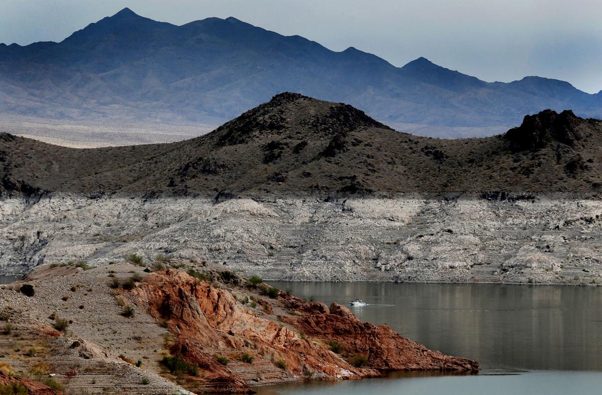
In the past year, water levels in Lake Mead fell about 16 feet, while Lake Powell has dropped about 47 feet. Between them, the two reservoirs are currently storing about 15.73 million acre-feet, well below their combined capacity of about 50.44 million.
Powell is 28% full and Mead is 34% full, federal records show. They were nearly full at the turn of the century.
“They should not wait for the reservoir to fall below 1,025 feet” to make more drastic cuts in water deliveries, Wheeler said. “That should begin as soon as possible.”
Both the 2019 drought contingency plan and the current plan, known as “500-plus,” are seen as short-term fixes for Lake Mead until a longer-term plan can be approved. That’s supposed to occur when all seven Colorado River Basin states negotiate a replacement for a set of broader federal guidelines that expire in 2026.
Both the 2019 plan and the new plan were developed in response to concerns about potential short-term water crises erupting that would require more drastic cutbacks. Work on the latest plan started only four months ago, after a federal forecast predicted Lake Mead could fall to 1,030 feet by July 2023.
Under the 2019 plan, once Mead is forecast to fall that low, the Lower Basin states would be required to start negotiating additional cuts in water use.
Now, the additional 500,000 acre-feet in savings from the new plan is expected to prevent Mead from falling below 1,020 feet, computer models used by various water agencies have found.
The CAP, the Arizona Department of Water Resources, the federal reclamation agency and water agencies in California and Nevada will spend $200 million to compensate various water users for leaving water in the lake.
Reacting to Wheeler’s comments, Terry Goddard, chairman of the Central Arizona Project’s governing board, said this week that he thinks the water agencies have already “to some degree” sped the pace of conservation by pushing through the “500-plus” agreement.
While a 10% chance exists that this plan’s savings won’t be enough to maintain adequate reservoir levels, “those are pretty good odds,” Goddard said.
But that doesn’t necessarily mean more cuts won’t be needed in the near future, he said.
Bronson Mack, a Southern Nevada Water Authority spokesman, said, “We continue to evaluate the risk, and have evaluated the risk to date. We’ve agreed on voluntary actions of the 500-plus plan over the next two years. That certainly doesn’t foreclose additional actions in the future should the risks continue to evolve.”
Sarah Porter, director of an Arizona State University water research and policy center, said she’s uncertain whether the “500-plus” plan will save enough water quickly enough.
But, “for sure, we have to stop being in this emergency mode that we’ve been in,” she said.
“The analogy to this is what’s gone on with forest fire management. We’re using all the money to fight fires rather than treat forests (to prevent fires). And we’re using vast sums to keep water in reservoirs, instead of investing in long-term water resiliency,” said Porter, director of ASU’s Kyl Center for Water Policy.
“Instead of being in firefighting mode, it starts with coming to terms with a reasonable expectation of the production of the watershed and looking for ways of permanently reducing consumption.
“These are short-term deals,” Porter said of the drought plans that were approved in 2019 and the one now being announced.
In February, Wheeler and the other researchers working under Utah State’s Center for Colorado River Studies released a study that warned managing the river sustainably will require substantially larger cuts in use by Lower Basin states than currently envisioned, along with curbs on future river water diversions by Upper Basin states. The Lower Basin cuts could be twice what was approved for the 2019 drought plan, the study concluded.
If river flows keep declining as temperatures rise, “aggressive commitments to water conservation” would be needed in both basins just to keep 15 million acre-feet in the reservoirs, the study said.
The 15 million offers “a minimum level of water security,” Wheeler said at the time. That would keep reservoirs holding 6.5 million acre-feet above what’s needed to keep producing power at Glen Canyon Dam and to let users keep taking water out of Lake Mead.
But now, this year’s dramatic declines at Lakes Mead and Powell have already reduced their total storage to about 15.7 million acre-feet, federal records show.
“Any buffer that existed at the beginning of the year is now gone,” Wheeler said. “We lost that buffer much faster than expected.”
Wheeler said he can’t be more specific about how much and how quickly additional cuts are needed. He and other researchers plan to publish conclusions early next year, based on follow-up research.
Goddard, the CAP board chairman, acknowledged the uncertainty of the current situation, adding, “We’re dealing with complete unknowns here. We’re dealing with new hydrology on the river.
“We still have to work on what the river is doing on a year-to-year basis and realize there could be significantly less water than we expect.”
Photos of Southern Arizona's devastating floods of 1983
October 1983 flood
Updated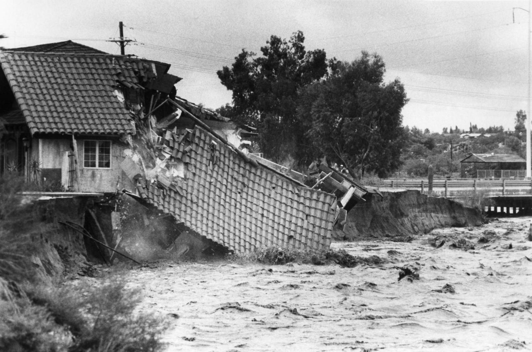
A building crumbles into the Rillito during October flooding in the El Niño year of 1983.
Floods of October, 1983
Updated
A Tucson subdivision at Prince and I-10 was caked in mud by Santa Cruz River in October 1983.
Flooding in October, 1983
Updated
Three men float in inner tubes along the Rillito River on Oct. 4, 1983. Photo by Joy Wolf / Arizona Daily Star
Flooding in October, 1983
Updated
Water surges in the Santa Cruz River at the St. Mary's Road bridge on Oct. 2, 1983.
Flooding in October, 1983
Updated
Two dogs lounged outside the Alpine Lodge in Summerhaven on Mt. Lemmon after the main street was washed out due to flooding on Oct. 4, 1983.
Floods of October, 1983
Updated
Nogales, Ariz,. police officers rescue Oscar Mankel. 32, with a garden hose from swirling waters of the flooded Santa Cruz River on Oct. 2, 1983, after Mankel fell in. A total of 13 lives were lost in flooding that ravaged much of southern Arizona. October 2, 1983.
Floods of October, 1983
Updated
Riverview Country Homes at 3750 N. Country Club are threatened by high water on Oct. 3, 1983. Photo by Emmet Jordan / Arizona Daily Star
Floods of October, 1983
Updated
The old lighthouse and adjacent building were ravaged by the overflowing Rillito River on Oct. 3, 1983.
Floods of October, 1983
Updated
Onlookers watch the flooded Rillito River from the north bank at 1st Ave. on Oct. 2, 1983. Photo by Alan Dorow / Arizona Daily Star
Floods of October, 1983
Updated
People on horseback saunter down a flooded street in Willcox, Ariz. on Oct. 3, 1983. Photo by Joe Patronite / Arizona Daily Star
Floods of October, 1983
Updated
Flooding from the San Francisco River near Safford, Ariz., in 1983. Tucson Citizen file photo
Floods of October, 1983
Updated
Flooding from the San Francisco River in Clifton, Ariz., in October, 1983. Tucson Citizen file photo
Floods of October, 1983
Updated
Flooding from the San Francisco River in Clifton, Ariz., in October, 1983. Tucson Citizen file photo
Floods of October, 1983
Updated
Flooding from the San Francisco River in Clifton, Ariz., in October, 1983. Tucson Citizen file photo
Floods of October, 1983
Updated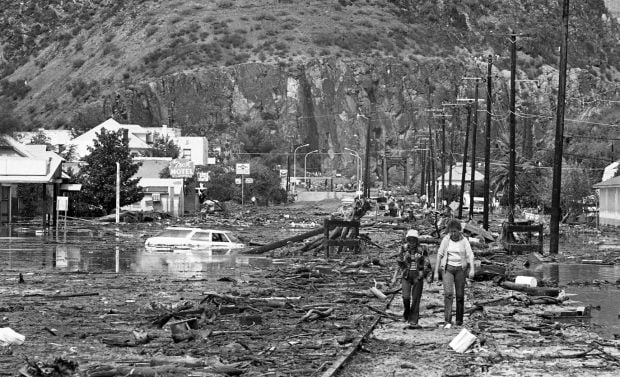
Flooding from the San Francisco River in Clifton, Ariz., in October, 1983. Tucson Citizen file photo
Floods of October, 1983
Updated
Flooding from the San Francisco River in Clifton, Ariz., in October, 1983. Tucson Citizen file photo
Floods of October, 1983
Updated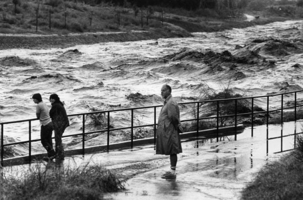
Rillito River flood rages as onlookers watch. October, 1983. Arizona Daily Star file photo.
Floods of October, 1983
Updated
One of many bridges destroyed by flooding on the Santa Cruz and Rillito rivers. October 1983. Arizona Daily Star file photo
Floods of October, 1983
Updated
Flooding in Tucson. October, 1983. Arizona Daily Star file photo.
Floods of October, 1983
Updated
Santa Cruz flooding with CDO Wash dry at bottom. October 4, 1983 Photo by Joan Rennick / Tucson Citizen
Floods of October, 1983
Updated
Ed Coatts found his motorcycle in axle-deep water in Willcox Monday, but he got it started and drove it through the torrent. October 5, 1983. Photo by Mari A. Schaefer / Tucson Citizen.
Floods of October, 1983
Updated
Flooding in Marana after the Santa Cruz River overflowed its banks in Oct. 1983. Tucson Citizen file photo
Floods of October, 1983
Updated
Flooding in Marana after the Santa Cruz River overflowed its banks in Oct. 1983. Tucson Citizen file photo
Floods of October, 1983
Updated
Arizona National Guard helps evacuees. Flooding in Marana after the Santa Cruz River overflowed its banks in Oct. 1983. Tucson Citizen file photo
Floods of October, 1983
Updated
Flooding in Marana after the Santa Cruz River overflowed its banks in Oct. 1983. Tucson Citizen file photo
Floods of October, 1983
Updated
Wreckage of a Arizona Dept. of Public Safety helicopter that crashed during the flooding. Two officers died. Flooding in Marana after the Santa Cruz River overflowed its banks in Oct. 1983. Tucson Citizen file photo
Floods of October, 1983
Updated
Flooding in Marana after the Santa Cruz River overflowed its banks in Oct. 1983. Tucson Citizen file photo

