


At the end of October, Lake Powell stood at 3,544 feet elevation. That’s 31 feet lower than federal forecasters predicted two years ago would be the lowest likely water level by now.
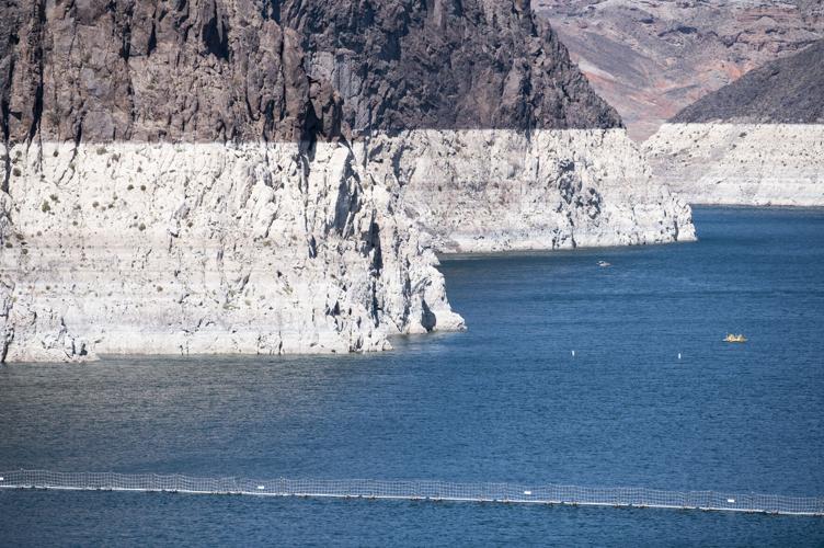
Lake Mead finished October at 1,066 feet, 8 feet lower than a similar 2019 federal forecast predicted.
With such poor forecasts as a backdrop as the climate heats up and river flows decline, the U.S. Bureau of Reclamation has changed how it predicts Colorado River reservoir levels, to try to bring forecasts in line with today’s warmer, drier world.
The newer forecasts are clearly more pessimistic, but a prominent climate scientist asserts they’re still not pessimistic enough.
Just in the last two months, the bureau’s two most-watched federal forecasts for the river began using or more heavily emphasizing recent climate and river flow patterns on which to base predictions.
Specifically:
In October, the bureau’s 24-month study, which every month forecasts reservoir levels two years in advance, started basing predictions on climate data from the period 1991 through 2020. Before, it used data from 1981 through 2010, which included the wetter 1980s — not the drier 2010s. The study predicts monthly elevation changes at Lakes Mead and Powell and 10 other reservoirs in the basin.
In September, the bureau started publicizing only the most conservative of two types of five-year forecasts it had posted four times a year for longer-range reservoir levels at Lakes Mead and Powell. Its sole published forecast is now based only on what it calls “stress test” hydrology, using river flows from 1988 through 2019 to shape predictions. Until now, it had also posted separate, long-range forecasts relying on river flows dating as far back as 1906.
These forecast tools are significantly improved in the eyes of Brad Udall, a leading Colorado River climate scientist who for more than a decade has been at the forefront of warning about reservoir declines.
But he still says that instead of basing forecasts on climate from the late 1980s into the 1990s, the bureau should only use the 22 years since 2000, when the current hot, dry period began.
His review of the bureau’s 24-month studies done since 2000, for instance, found their forecasts for Powell’s minimum likely reservoir level were about 30% too high on average, he said. He’s concerned the forecasts are underplaying and soft-pedaling the risks the reservoirs will go dry.
“Reclamation is using 20th century methods for a 21st century problem,” wrote Udall, a Tucson native and a Colorado State University senior water researcher, in an email to the Star. “The methods would be fine if the climate were not changing. Unfortunately, under a rapidly changing climate the methods fail to adequately forecast future conditions (and risks).”
His view is shared at least in part by other outside water experts, including University of New Mexico researcher and author John Fleck, and Eric Kuhn, a retired general manager of a Western Colorado water district who is now a water researcher.
But the bureau defends its forecasting methods as being in line with those employed by other agencies, including the National Oceanic and Atmospheric Administration and the World Meteorological Organization. NOAA calls its practice of updating every 10 years the time span on which it bases forecasts “the equivalent of the census for those who use the data.”
An official with NOAA’s Colorado Basin River Forecast Center, which supplies much of the data that underlies the forecasts, says its mission is to provide unbiased forecasts that provide for a wide range of runoff possibilities.
“Using a shorter forecast period may result in an overall drier forecast but may also result in narrower range of runoff possibilities (e.g., any future wet periods may not be forecast accurately),” wrote Ashley Nielson, a river forecast center senior hydrologist, in an email. “To account for the large amount of hydroclimactic variability within the Colorado River Basin, we cannot only rely on dry scenarios.”
Forecast led to CAP shortage decision
Done with computer models into which historical climate and river flow data are fed, the forecasts are not just academic in nature. The bureau uses each August 24-month study, for instance, to determine how it will operate the reservoirs in an upcoming calendar year.
It used the August 2021 24-month study to announce its first shortage for 2022, in which it will slash deliveries of river water to all Arizona by 18%, or 512,000 acre-feet, and to the Central Arizona Project by about one-third.
The CAP delivers drinking water to Tucson and Phoenix and irrigation water to Pinal County via a concrete canal.
The same forecast also determines how much water Lake Mead will get each year for deliveries to Lower Basin states including Arizona, and how much will be left behind in Powell for future deliveries to Lake Mead.
Meanwhile, the five-year projections are meant to help water managers better plan for the future using the best available data, Jacklynn Gould, who oversees the lower basin for the agency, told the Associated Press. These forecasts can provide early warnings that trouble lies ahead.
The five-year forecast is more for “what if” games, observed Jeff Lukas, a Colorado water and climate researcher who last year co-authored a paper on “The State of the Science” on Colorado River Basin climate and hydrology.
“You have risk numbers you can take from it that are meaningful” to affected interests, he said.
Making forecasts more complicated is that the 24-month study offers three predictions at once: “most probable,” “minimum probable” and “maximum probable” reservoir elevations. The most probable are the most important forecasts, since the bureau uses them to decide on future shortage declarations and reservoir releases.
But sometimes minimum probable forecasts can have major ramifications.
Just this August, a minimum probable forecast for Lake Mead to fall to 1,030 feet in two years forced Lower River Basin states to start negotiations over a plan to save 500,000 acre-feet of additional water — beyond the 512,000 acre-feet required by next year’s shortage — to keep Mead from falling below 1,020 feet.
To justify its exclusive use of stress testing for the five-year forecast, the bureau notes the 1988-2019 period’s flows were on average 10% drier than from 1906-2019.
Also, multiple studies identified a shifting temperature trend in the Colorado River Basin starting in the late 1980s that resulted in lower average flows for the same amount of precipitation, the bureau recently wrote on its website.
Consistent shift to drier future
The impact of the changed forecasting methods is already clear.
The most, minimum and maximum probable forecasts in the October 24-month study showed a consistent shift to a drier future for Powell, wrote Kuhn on fellow researcher Fleck’s Inkstain blog.
From Oct. 1, 2021, through Sept. 30, 2022, the median level of total flow into Powell — in which half the flows would be less and half would be more — will now be 800,000 acre-feet less than previously forecast, the bureau said.
Powell’s levels are important to Arizonans, particularly because the lake exists to make sure the Upper Basin — Wyoming, Colorado, Utah and New Mexico — has stored enough water to meet legal obligations to deliver water to the Lower Basin, which includes Arizona, California and Nevada.
The minimum probable forecast for October showed Lake Powell at 3,467 feet in 2023, 15 feet below the September forecast, Kuhn noted. That forecast also had Powell spending nine months in 2022 and 2023 below 3,490 feet, at which Glen Canyon Dam’s turbines could no longer generate electric power. That compares to 2.5 months below 3,490 in the September forecast.
“From a cash flow perspective, the difference is about $200 million less,” in power sale revenues, Kuhn wrote.
The latest stress test-based, long-term forecast, from September 2021, raised alarm bells across the basin. It found a 34% chance that Powell could fall below 3,490 feet in 2023 and a 41% chance that Mead will fall below 1,025 in 2025 and 2026.
At 1,025, the worst possible Lower Basin river shortage now authorized under current guidelines would be declared, cutting off 720,000 acre-feet from CAP — close to half its annual supply.
“We have had to make difficult choices this year, and we will all have to make more difficult decisions if it continues to remain dry next year to protect Lake Mead and Lake Powell,” said Gould, the Lower Colorado Basin regional director, in a news release.
Forecasts still called “too rosy”
On his blog, Fleck offered “kudos” to the Bureau of Reclamation’s scientists and managers for making the stress test, now a decade old, its default method for five-year forecasting.
“The traditional approach — using the entire period of record to model the probabilities of future river flows — is no longer valid because climate change is changing the river,” Fleck wrote.
But he and Udall also say the stress test isn’t stressful enough. They noted that during the stress test period of 1988-2019, the Colorado’s flows averaged 13.3 acre-feet annually, compared to 12.4 million since 2000.
“When river managers first began using it, the ‘stress test’ marked an important step toward taking climate change seriously. But these flows are no longer what they purport to be,” the two wrote in another blog post.
Udall told the Star that the flows the 24-month studies had projected for Lake Powell since 2010, until its method changed in October, were a total of about 2 million acre-feet higher than what has actually entered the lake since then.
He estimated the bureau’s new forecast methods would still be 1 million acre-feet too high, compared to Powell’s levels since 2010.
While minimum probable forecasts are supposed to be exceeded in real world conditions 90% of the time, his review of 24-month studies since 2012 found the minimum probable forecast was only exceeded 70% of the time when looking a year ahead, Udall wrote.
“This means that 30% of the time, this minimum probable forecast generates forecasts that are too rosy,” he said. “Reclamation advertises the minimum probable forecast as (having) a 1 in 10 chance of being wrong. It isn’t. Since 2012, it has been wrong 3 in 10 times.
“To call 3 in 10 ‘minimum probable’ is contrary not only to what Reclamation claims it to be, but also how most people would interpret the words ‘minimum probable,’” he said.
The current October 2021 minimum probable forecast says Powell will hold 3 million acre-feet by spring 2023, he said. Udall’s calculation, however, suggests that number should be about 1 million lower, filling the lake only 3,443 feet high, about 100 feet lower than it is now.
Overall, he said,”Given that we’ve lost two-thirds of the contents of those reservoirs, we need to completely understand how likely it is that those reservoirs dry in the next few years. We’re soft pedaling that risk. It’s much higher than anyone should be comfortable with.”
“The bureau’s forecasting is ‘following the rules,’ but when do you decide those old rules no longer make sense?” Udall added.
Bureau defends methods
In emails to the Star, the bureau didn’t directly rebut Udall’s criticisms but a spokesperson defended the agency’s forecasting methods.
Becki Bryant, a spokeswoman for the bureau’s Upper Basin office, said of Udall, “He is a strong advocate for the Colorado River and collaborates with many, including Reclamation, to ensure the river’s future vitality. We do not have a response to his comments and we look forward to continued collaboration.”
Patti Aaron, a spokeswoman in the agency’s Lower Basin office, noted the recent shift to using 1991-2020 data is standard practice for all federal river forecast centers.
“We often receive suggestions from the public and take them into consideration,” Aaron said when asked about Udall’s concerns.
Fleck said he agreed with Udall that the 24-month study’s methods remain too optimistic. Kuhn, however, said he can see both sides of the 24-month study debate.
“The normal NOAA standard for climate is to use the last 30 years (to make forecasts). When you move from a 1981 to a 1991 start for the 24-month study, that was a big difference,” Kuhn said. “I think Brad is right but the shift to ‘91 has made the error much less. It’s a step in the right direction.”
Researcher Jeff Lukas said he’s not quite convinced that forecasting should switch to only using 21st century years. The period starting in 1988 already has a lot of warming baked in, compared to the entire 20th century, he said.
From 1991 to 2020, temperatures in the river’s Upper Basin averaged about 2 degrees F warmer than those of the entire 20th century. Looking just at the last 10 years adds another .8 of a degree F, meaning the period 1991-2020 already includes a fair degree of the warming that’s occurred in recent times, Lukas said.
Much of the debate over forecasting revolves around the question of whether all the declines in precipitation in recent years, which are blamed for about one-half the reduction in Colorado River flows since 2000, are permanent or cyclical, Lukas said.
“We know the warming we’ve seen in the last 20-30 years is going to continue and maybe get steeper. What we don’t know is if the decrease in precipitation in the Upper Basin over the last 20 years is showing us an overall shift.”
Udall said he sees no sign that river flows will ever rebound. “And in fact, science tells us these flows are likely to continue dropping so long as humans emit planet-warming greenhouse gases,” he said.
Lukas said he’s not convinced Udall is wrong.
“The right and wrong is not up for scientific debate. It’s more in the hands of the folks with a stake in the system,” he said. “With the reservoirs down to 30% (of capacity), with the system already so depleted, do you want to count in any way on precipitation snapping back closer to the 20th century average?
“Or,” he asked, “do we shift to the worst case scenario?”

