


The U.S. Fish and Wildlife Service says it used the best available science to reach its biological opinion that the Rosemont Mine won’t jeopardize 12 endangered species living nearby.
The mine’s critics note that two other federal agencies, including the Environmental Protection Agency, have said that science is far from good and that the computer models underlying it are seriously flawed.
The wildlife service used Forest Service forecasts, based heavily on three computer models, to help shape its opinion that the mine is unlikely to dry up neighboring Cienega Creek in at least the next 150 years, although it could dry up part of a tributary.
The biological opinion also concluded that the mine won’t destroy the endangered species’ critical habitat.
Completion of that opinion, released last week, was a key step required for final decisions on the $1.5 billion mine by the Forest Service and the Army Corps of Engineers.
“You may have heard the saying that all models are wrong and some are useful,” said Steve Spangle, field supervisor for the wildlife service’s Arizona ecological services office. “Unless you have a crystal ball, you need a scientific model to predict the outcome.
“People always take shots at models and the models by definition include assumptions that may be right or wrong. You take the best fit assumptions, and model those and come out with a series of possible outcomes. There are always going to be criticisms of any model — that is the nature of the beast,” Spangle said.
“We did what the law requires, which is using the best available information,” he added.
But as the Forest Service kept producing environmental reports relying on the computer models over the years, the EPA and the Bureau of Land Management kept challenging them.
The EPA and BLM have questioned the very use of computer models to predict what could happen to Cienega Creek 150 to 1,000 years from now. The EPA has urged the Forest Service to conduct a formal risk assessment that doesn’t employ computer models.
While the Forest Service has done many runs of the models, some things simply aren’t knowable, said Jason Brush, wetlands office supervisor in the EPA’s San Francisco regional office.
“It comes down to risk — what’s the best state of our knowledge of risk? We have drought and climate change in an arid state. There’s a debate over this or that model, and significant questions of whether it will happen in X or Y year. Everything we’ve seen suggests there will be impacts,” Brush said in an interview last month.
Last week, the EPA, asked for comment on the biological opinion, said only, “The EPA remains engaged in the multi-agency process for the Rosemont Mine proposal.”
BLM spokesman Adam Milnor said the agency probably won’t comment until the Forest Service and the Army Corps of Engineers make their decisions. The BLM legally can protest the Forest Service’s decision, while the EPA can seek a higher review of it and can veto the Army Corps decision.
Also last week, the Tucson-based Center for Biological Diversity, which opposes the mine, released a study it commissioned from a hydrologist that blasted the Rosemont models. Issues with the models’ basic methodology, calibration and other aspects are so great that it’s difficult to trust the Forest Service’s conclusions about Rosemont’s impacts, said the report from Robert Prucha, of Integrated Hydro Solutions in Golden, Colorado.
“There’s a series of steps used to create a model and there are actually industry standards used to create them, to collect data and to characterize the natural systems, “ Prucha said in an interview. “I had trouble with a number of steps they took. My sense is that they made some mistakes.”
On Friday, Coronado National Forest Supervisor Kerwin Dewberry and Spangle said they’ll be reviewing the reports.
“Our environmental analysis of the project involved detailed study of complex subjects. We believe a thorough analysis utilizing the best available science was conducted during our process, in compliance with the National Environmental Policy Act,” Dewberry said.
CONSERVATION AREA
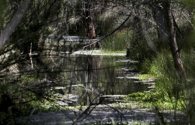
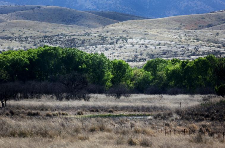
Cienega Creek is the centerpiece of the Las Cienegas National Conservation Area. That’s a federally owned parcel of grasslands, pools, streams and cottonwood groves a few miles east of the mine site. It’s also the centerpiece of the debate over the Rosemont biological opinion and the computer models.
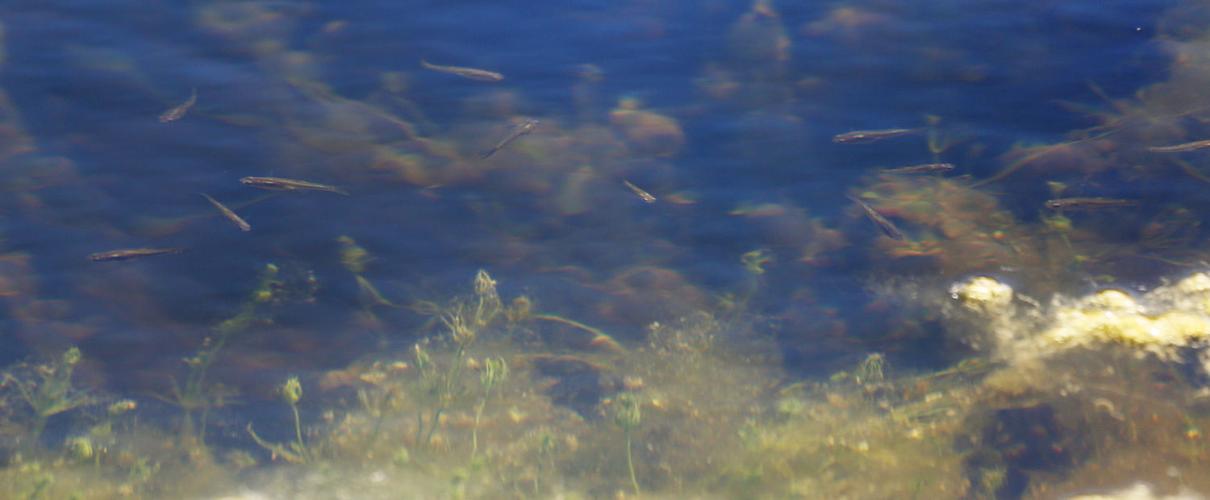
Cienega and its tributaries, wetlands and pools are home to eight of the 12 imperiled species studied. Of them, the endangered Gila topminnow is particularly dependent on the creek.
In 1998, the wildlife service wrote in a topminnow recovery plan that Cienega is the single largest topminnow habitat, stretching nearly six miles at the time although it has since shrunk some. Cienega holds by far the U.S.’s largest topminnow population, one of six natural populations (along with 40 that were reintroduced) and the only one left on public land, the service said in the Rosemont biological opinion.
The topminnow is abundant in upper Cienega Creek inside the BLM-owned conservation area. It has also been found in Pima County’s Cienega Creek Natural Preserve, downstream of Las Cienegas.
The concerns about Cienega arise because construction of the mine would require digging a half-mile-deep open pit. The pit would “function as a well,” pulling in surrounding groundwater, the biological opinion said.
That has raised concerns that the depleted aquifer would have less water to supply Cienega Creek.
The models that forecast how the groundwater would behave were produced by two Rosemont consultants — Tetra Tech and Montgomery & Associates — and by Tom Myers, a Nevada hydrologist hired by Pima County, whose officials oppose the mine.
Their analyses were refined by Forest Service reviews, ending with a supplemental biological analysis last year from that agency.
From there, the wildlife service’s opinion said two key stretches of the Upper Cienega would likely lose at most 11 percent of their streamflow after 150 years during June, the driest month. In two key stretches of Lower Cienega, the creek would still carry 98 percent and 89 percent of its June streamflow, respectively, the biological opinion said.
But for tributary Empire Gulch, a third of a mile stretch of perennial stream could start running only after storms, the opinion said.
Empire Gulch has no topminnows, although it does hold the threatened Chiricahua leopard frog, Western yellow-billed cuckoo and northern Mexican gartersnake, and the endangered Gila chub and Southwestern willow flycatcher.
Last week, the wildlife service’s Spangle noted that his agency based its conclusions on what could happen in 97.5 percent of all possible outcomes predicted by the Forest Service. While the biological opinion didn’t look at the worst-case scenario, it examined a wide range of possibilities, he said.
“The analogy is predicting the path of a hurricane,” he said. “When a news report tries to predict that, they have a pretty good idea of where it hits tomorrow but the farther out you go, the wider the range of possible outcomes. With the unpredictability of this going out a century or more, we felt we covered 97.5 percent of possible adverse effects.”
In consultant Prucha’s new report for the anti-mine biodiversity group, he took aim at assumptions used for the models and what he said was limited data collection from the Las Cienegas area. He said the models failed to use standard hydrological practices and did not account for Las Cienegas’ current groundwater flow to understand how the mine might affect it.
“They failed to use the best modeling science. They cherry picked the data, to secure the results they desired,” said Robin Silver, the biological diversity group’s conservation chairman.
GROUNDWATER IMPACTS
Spangle also said the wildlife service and Forest Service made extensive use of U.S. Geological Survey scientists in conducting their reviews, the mine’s impacts and the computer models. The Geological Survey is generally considered to be the most neutral agency involved in the mine dispute.
Not only did USGS scientists review the groundwater models, they also did separate reviews of three consultant reports that looked more closely at the mine’s impacts on Cienega, said Jason Douglas, a wildlife biologist for Fish and Wildlife.
“We needed professional interpretation of what those models would tell us,” Spangle said. “They believed that we were using the best models available.”
Mine opponent Silver criticized Spangle’s statement, since the USGS last year took issue with the Forest Service, outlining three steps it could take to “substantively improve” the model’s ability to simulate the area’s groundwater’s behavior, according to a Forest Service memo.
The Forest Service balked, saying none would likely change the models’ basic conclusions or bring significant gains in knowledge, the March 31, 2015, Forest Service memo said.
USGS’s Jim Leenhouts said he can’t recall his scientists making the “best models available” statement verbally or find written comments to that effect. Leenhouts, director of the survey’s Arizona Water Sciences Center, added that it’s possible such a comment was made: “Those are the available models.”

