

Stop your shivering and sniveling.
This winter has been neither abnormally cold nor overly wet — current conditions notwithstanding.
On Monday, forecasters said it will be below freezing on Tuesday, Wednesday and Thursday mornings, with a hard-freeze watch in effect for overnight Tuesday.
With the first two months of meteorological winter in the books, Tucson is 0.4 degrees below normal for temperature and just a smidge wetter than average.
Forecasters still hold out hope that a weather pattern caused by the warm waters of the Pacific Ocean, part of a very strong El Niño pattern, will reassert itself in the coming months.
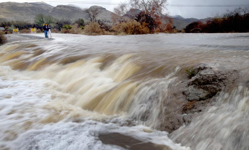
That pattern, which brings moisture across Southern California and into Arizona and beyond, dumped prolific amounts of rain and snow across the state on Jan. 4 and Jan. 7, and more modest moisture on Sunday night and Monday.
It made for a wetter-than-average January that combined with a dry December for a winter rainfall total in Tucson of 2 inches, just 0.13 inch above normal.
Monday’s short-lived storm didn’t account for much, though the snow piled up in higher elevations. The next couple weeks will be dry and warm, said Mike Crimmins, a climate specialist at the University of Arizona.
The weather folks have said all along that a strong El Niño, which we’re still experiencing, usually brings extra rain, but sometimes does not.
They still hold out hope that February, March and even April will be wetter than normal.
Crimmins helped author a CLIMAS report last month that said the second half of winter might be wetter. Now, with the February long-term forecast looking a bit sere, he’s not so sure. It certainly won’t be the soggy winter he once envisioned. “In my imagination, we had rain every day, waterfalls everywhere and gray skies,” he said.
The reality was short bursts of storms in December and January, followed by dry days
“I’m going to be a perpetual pessimist for the rest of the event, because it will never meet my expectations,” said Crimmins, a climate science extension specialist.
The lack of moisture led to temperature extremes as the desert cooled off quickly after dark. Warm days were followed by cool nights. January’s temperature extremes were 81 degrees and 31 degrees.
Overall, Tucson averaged a very normal 52 degrees for the first two months of winter, according to the climate report compiled monthly by John Glueck of the National Weather Service in Tucson.
Models hint at a return of a more typical pattern, with maybe a burst of rainfall later in February, and a wetter than average March, Crimmins said. “El Niño still has its hold on our climate,” he said.
The other good news is the snowpack, he said. “The stations in the mountains are in amazing shape, way ahead of average for this time of year.”
Most of the state is out of drought. “These are the best conditions we’ve had in five years,” he said.
Monday’s storm gives way Tuesday to clear skies and lower temperatures. A hard-freeze watch is in effect for Tuesday night and Wednesday morning, when the Tucson temperature will drop to around 26 degrees, said Greg Mollere, meteorologist with the National Weather Service. It will be even colder elsewhere in Southern Arizona.
No rain is forecast for the next seven to 10 days, Mollere said. Temperatures will rise gradually, with highs in the 70s by the weekend.

