

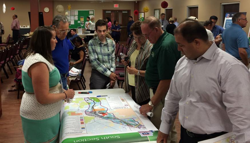

Options for a new interstate in Arizona were presented to a packed audience Wednesday during the first public hearing on the proposed Interstate 11.
Project engineer Jay Van Echo said the goal of the I-11 corridor is access-controlled, north-south transportation that connects U.S. metropolitan areas with Mexico and Canada.
He said the final corridor could be one entirely new route or several new routes, connected to improved existing routes.
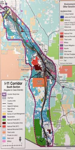
The maps unveiled Wednesday show alternatives for the interstate run west of Interstate 10 from Wickenburg south to Casa Grande. There, the southern options are east or west of I-10, connecting to Arizona 189 in Nogales with access to the international port.
An earlier proposal by Pima County had I-11 connecting to the existing Interstate 19 for southbound travel.
The Arizona Department of Transportation said no specific alignments are under consideration at this early stage.
The study area for the proposed route is about 280 miles long and between 5 and 25 miles wide.
Representatives from ADOT and the Federal Highway Administration were on hand at Wednesday’s hearing in Casa Grande to answer questions from residents.
In order to record all concerns, comments were taken in writing or by a court reporter for those who preferred to verbally share their thoughts.
“I’d start it tomorrow,” said Casa Grande resident Louis Wagner, who attended the meeting to see if land he owns would be impacted. “I’m open to it.”
Mike Henderson, also from Casa Grande, called himself a “big fan of north-south commerce.”
He said he had advised officials to coordinate with parallel efforts along the corridor.
“It fascinates me that some of these things go so slowly,” Henderson said.
The hearing served as a kickoff to a three-year environmental study, in accordance with the National Environmental Policy Act, ADOT’s Van Echo said.
An Environmental Impact Statement will evaluate corridor alternatives, including segments that could be independent projects.
A no-build alternative also will be evaluated.
No funding for the project has been identified.
ADOT will collect data for the next year and come back to the public with specific route alternatives, Van Echo said.
Double-decking
“still on table”
I-11 began as the Canamex Corridor.
As defined by Congress in the 1995 National Highway Systems Designation Act, the corridor is a joint effort involving Arizona, Nevada, Idaho, Utah and Montana.
It calls for the development of a continuous four-lane roadway from Mexico through the U.S. into Canada to facilitate trade among the three countries and minimize traffic and congestion.
The federal government has spent about $500 million on the Mariposa Port of Entry in Nogales and the Hoover Bypass Bridge in Northern Arizona. I-11 would be the connection between the two.
Proponents believe the interstate would expedite southbound exports to Mexico and — from the Port of Guaymas — to markets in Latin America, Europe and Asia.
Northbound imports could avoid city traffic and connect from I-19 to the Port of Tucson or move to markets on the East Coast via I-10.
Opponents have said widening I-10 and double-decking parts in Pima County would serve the same purpose without additional infrastructure in the desert.
John Moffatt, Pima County’s director of strategic planning, said all ideas will be evaluated.
“It’s still on the table,” he said of double-decking parts of I-10. He said the county continues to collect feedback from residents potentially affected by the new interstate and to work with tribal and state land officials to propose a route with minimum impact.
“We are trying to be sensitive,” Moffatt said.
I-10 Coalition formed
Meanwhile, in a separate east-west interstate project, ADOT and the transportation directors from California, New Mexico and Texas entered into an agreement earlier this week to create an I-10 Corridor Coalition to address the movement of goods between California ports and the Texas market.
“For Arizona, the partnership is designed to remove what transportation officials refer to as “friction” — such as the variety of commercial vehicle permitting and inspection practices in each state along I-10 — that makes the movement of goods less efficient than it could be,” ADOT said in a statement announcing the partnership. “If the four states were combined, the region would have the 10th largest economy in the world.”
The coalition is modeled after a coalition involving 15 states that govern Interstate 95 between Florida and Maine.
“We want to see the day when a truck or a noncommercial vehicle can travel the 1,700 miles between Los Angeles ports and Houston ports — safely, efficiently and without delay,” said John Halikowski, ADOT director.
“Someday we want the I-10 corridor to be filled with truck platoons and connected vehicles, weigh-in-motion sensors and automated truck parking lots.”
In Pima County, officials hope to build a 26-mile connection between I-10 and I-19 as a bypass for northbound I-19 and westbound I-10 drivers, especially commercial vehicles.
The Sonoran Corridor would run roughly from Rita Road on the southeast side to about Pima Mine Road south of Tucson.

