


Trail runner Lydia Jennings decided to celebrate completing her doctorate with a 50-mile run on the Arizona Trail. A member of the Pascua Yaqui Tribe and an environmental microbiologist, she also did the run to honor 50 Indigenous scientists.
She planned to start at the U.S.-Mexico border and run north — a goal she was forced to change.
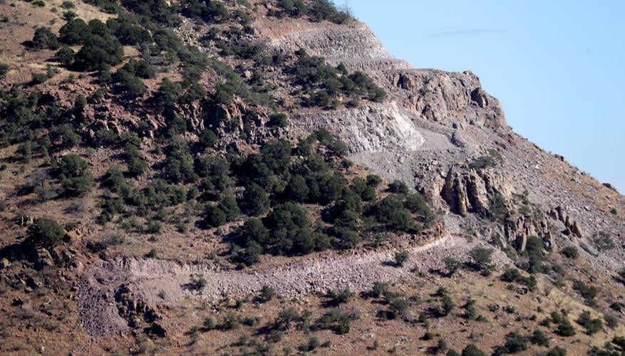
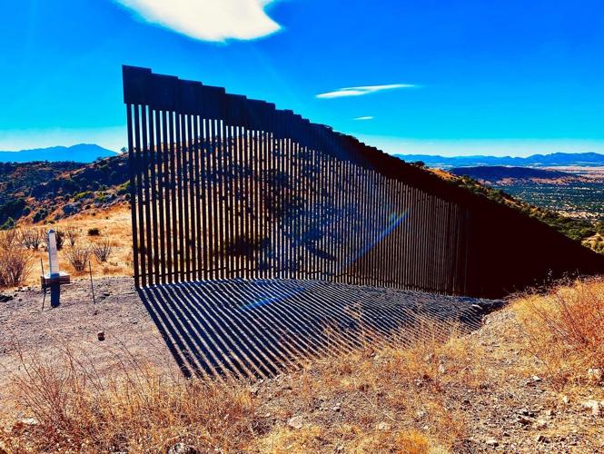
The southern terminus of the Arizona Trail, which ends at the Coronado National Memorial, was closed a year ago as construction crews built a 200-foot island of border wall in the days before President Donald Trump left office.
The trail is now set to reopen in the coming week, likely on Jan. 1, although the opening will probably be temporary, and trail advocates are concerned environmental damage from the wall construction will continue to be an issue.
The Department of Homeland Security announced on Dec. 20 that it will address issues left by unfinished border wall projects across parts of the southern border, with a large majority of projects located in the Tucson Sector.
Park officials have said no construction will take place at the southern terminus of the Arizona Trail for the next three to six months, but once construction restarts, the closure will probably resume.
The National Park Service isn’t officially announcing when the closed part of the trail will open until next week, and the plan for what sort of construction will eventually resume hasn’t been decided.
The Arizona Trail is one of 11 National Scenic Trails in the country and one of three that is complete, without any detours.
The end of the trail is now marked with access roads carved by dynamite into the mountainside and the free-standing section of wall — “an expensive, offensive art project,” says Matt Nelson, executive director of the Arizona Trail Association.
Historians believe that the terminus of the trail is where Spaniards first crossed into what is now the U.S., an event marked by the Coronado memorial marker. The wall stops just a few feet short of reaching that marker.

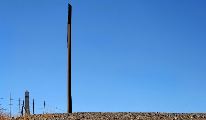
An orphan stretch of new wall on the U.S.-Mexico border, about 200 feet long, stands near border marker 102 at the southern end of the Arizona Trail.
It’s also on Indigenous people’s ancestral land, says the Trail Association’s website, as Native Americans have inhabited Arizona for more than 10,000 years.
Not being able to start her run there was a meaningful loss to Jennings.
“Native people have always been using these different trail passages to connect our communities from south of the border to north of the border,” she said. “I’m a member of the Pascua Yaqui Tribe, and our tribe is a binational-border tribe. And so I really wanted to highlight that by starting at the U.S.-Mexico border.”
Other hikers also felt the loss over the last year. As Jennings was training, she ran into hikers who said they didn’t feel like they were doing the full trail because they didn’t start at the beginning.
“People just feeling disappointed that they don’t have that and then also really reflecting on what a disservice it is to this amazing trail system that attracts so many,” she said.

The view to the south along Joe's Canyon Trail near Coronado Peak in the Coronado National Memorial.
Wall likely to remain
The border wall at the terminus of the Arizona Trail is part of a burst of construction that took place in the waning weeks of Trump’s presidency, work that came to a halt when President Joe Biden took office.
Between Jan. 4 and Jan. 8, Customs and Border Protection began construction on 12 additional miles of border wall, the New York Times reported.
Although places like the Arizona Trail are protected by the National Trail System Act, the government has the power to override that federal law in the name of national security, according to The Associated Press.
Customs and Border Protection did not provide information on the cost of this specific project at the southern terminus of the Arizona Trail. But Southwest Valley Constructors, an affiliate of the construction giant Kiewit, was awarded $524 million in March of 2020 to build about 24 miles of wall in Cochise County, where the site is.
The National Park Service closed the last mile of the Arizona Trail right before the construction.
Last week, Secretary of Homeland Security Alejandro Mayorkas authorized U.S. Customs and Border Protection to use border barrier funds to address “life, safety, environmental, and remediation requirements” for border barrier projects.
A news release said the projects include but are not limited to:
Completing and/or installing drainage to prevent flooding.
Erosion control to ensure the safety and stability of structures.
Completing prior construction of access roads by adding guardrails, signage and integrating existing roadways.
Remediating temporary use areas that have been affected by construction.
Disposing of residual materials.
Closing small gaps that remain open from prior construction activities and remediating incomplete gates.
The border wall in Arizona has many gaps, which in some places are just a few feet or a few yards. Construction materials left when contractors suddenly stopped working are still piled up in some places in the Southern Arizona desert.
Removal of incomplete segments of wall was not listed in the border remediation projects announced Monday.
“I don’t see immediate benefits from this decision for the Arizona Trail, but I will remain hopeful,” said Nelson, with the Trail Association.
Nelson recently took staff members of U.S. Rep. Ann Kirkpatrick, an Arizona Democrat, to the southern terminus of the Arizona Trail. Her team said it was a priority area for restoration, Nelson said.

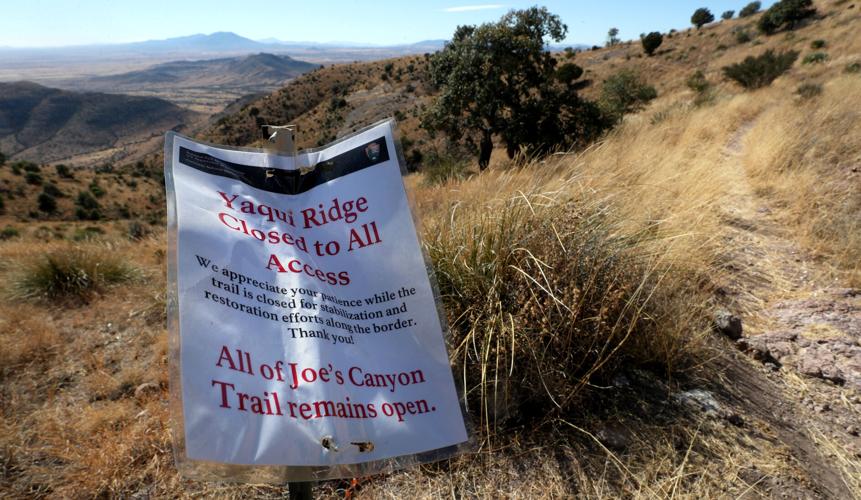
A sign warns hikers that the Yaqui Ridge Trail is closed, cutting off access to the southernmost portion of the Arizona Trail.
Her team was able to see some of the drainage concerns the area faces due to “haphazardly constructed roads built for construction vehicles” next to the very short “hastily built” section of wall, Kirkpatrick wrote in her November newsletter to constituents.
Nelson says a border wall never made sense in that remote part of the desert that no vehicles can get to and is miles away from the nearest town.
“It is perfectly reasonable to assume that technology can be used to keep the border safe in this area without compromising scenic resources and the physical landscape,” he said.
The Arizona Trail Association would like to see that wall removed, restoration of the surrounding land and the trail reopened as soon as it can be deemed safe.

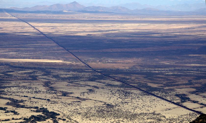
The border wall stretches east from the Coronado National Memorial south of Sierra Vista.
Some ignore the closure
Disobeying the closure of the Yaqui Ridge Trail — the southernmost mile of the Arizona Trail — is punishable by a fine of up to $5,000 or up to six months imprisonment.
But some hikers have been choosing to risk it in order to complete a trek that in some cases they planned for years. The Park Service hasn’t charged anyone who’s ignored the closure.
If trail walkers and runners disregard the closure, that’s telling the National Park Service they don’t care about their rules, said Steven Terry, a member of the Trail Association and a steward for the Rincon Mountains section of trail.
Terry hiked the entire trail in 2021, except the last 1.9 miles. Terry stopped at the Montezuma Pass parking lot, 2 miles from the terminus, although hikers can still do 1 mile of that before reaching the closure.
“If we as a community are going to disregard this closure order, it is going to make it harder when the Arizona Trail Association or a steward like myself reaches out to the Park Service to get something done and to get future trail access,” Terry said.
Terry finished the trail this month, after hiking it throughout the year in 11 separate sections. He saved the southern section for last, hoping the terminus might open.
“Did I plan to go from Utah to Mexico when I hatched this project last year? Sure I did,” Terry said. “But it was more important to do the right thing for the greater good and for the Arizona Trail Association and for the trail’s integrity itself than it was to just do something that would stoke my ego and give me some temporary likes on Instagram.”
Jake Eberspacher finished the 800-mile hike in fall of 2019, just months before the southern terminus closed. He’s also a volunteer steward for a remote part of the trail between Phoenix and Payson.

An orphan piece of border wall stands near marker No. 102. Work on the wall came to a halt when President Joe Biden took office.

The island of border wall stops just a few feet short of the marker, left, at Coronado National Memorial.
“I feel so fortunate to have done it when I did because I got to do the full trail all the way to the actual southern terminus, which is also historically significant,” he said.
When Eberspacher was there, there were just a few strands of barbed wire. But in the desert to the east he could see border wall cutting through the wild desert, stretching to the mountains far beyond.
“You can see this black line just kind of separating the desert. On either side of the wall, it’s the same vegetation,” he said. “You could tell deer would run through that landscape if the wall weren’t there. It’s one natural area, and there’s just this arbitrary line that we decided needs to go there.”
Photos of the U.S. – Mexico border fence
U.S. – Mexico border near Douglas, Ariz.
Updated
A dog stands on a road commonly used by Border Patrol near Slaughter Ranch Museum Thursday, Sept. 27, 2019.
U.S. – Mexico border near Douglas, Ariz.
Updated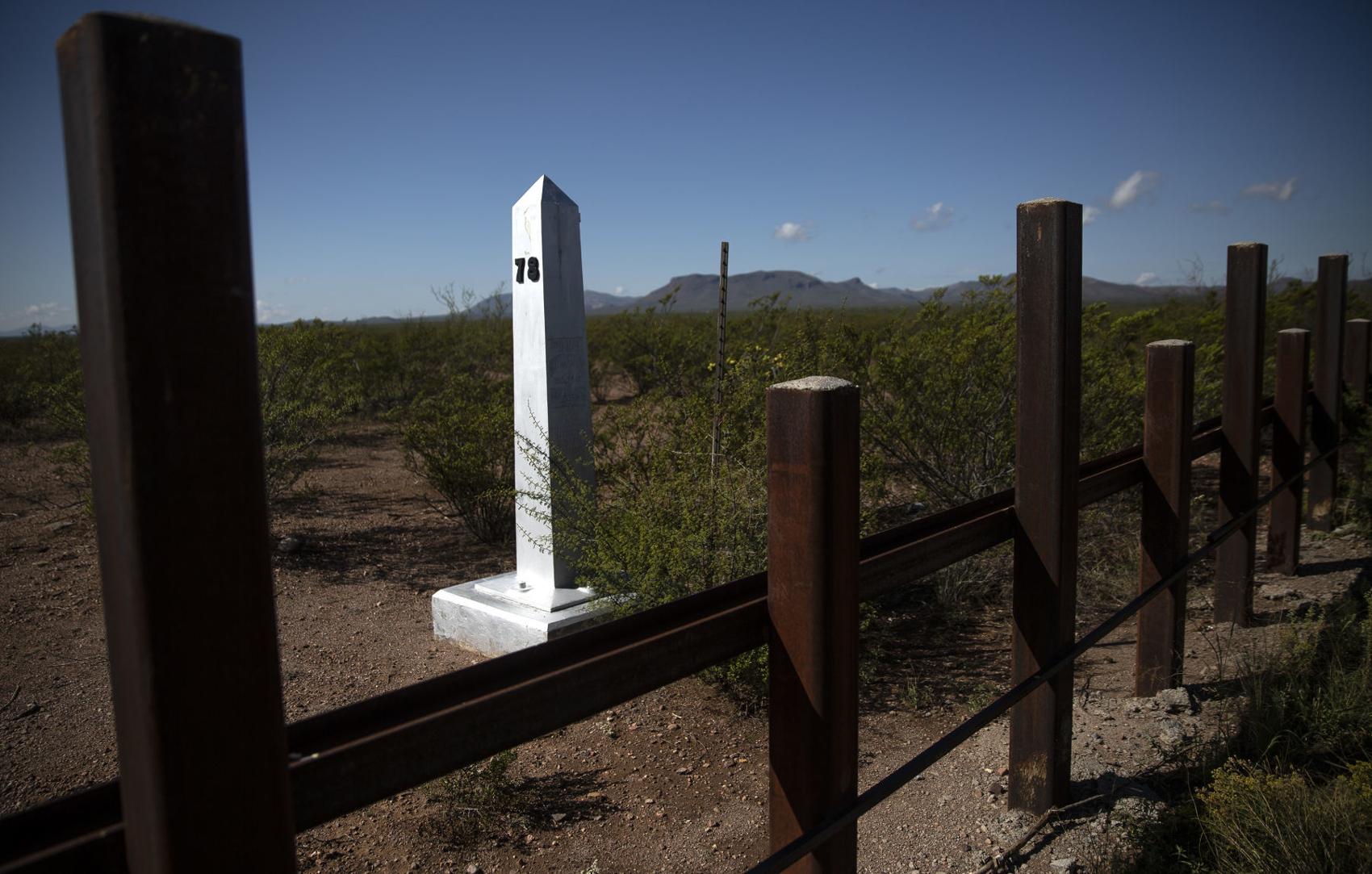
A border monument on the Mexico side of the border seen east of Douglas Thursday, Sept. 27, 2019.
U.S. – Mexico border near Douglas, Ariz.
Updated
The San Bernardino National Wildlife Refuge sits on the U.S. side of the border with Mexico east of Douglas Thursday, Sept. 27, 2019.
U.S. – Mexico border near Douglas, Ariz.
Updated
A bull and cow graze near the site of new wall construction east of Douglas Thursday, Sept. 27, 2019.
U.S. – Mexico border near Douglas, Ariz.
Updated
The border seen stretching from hills east of Douglas into the Guadalupe Mountains Thursday, Sept. 27, 2019.
U.S. – Mexico border near Douglas, Ariz.
Updated
Flowers grow around border fencing near the San Bernardino National Wildlife Refuge Thursday, Sept. 27, 2019.
U.S. – Mexico border near Douglas, Ariz.
Updated
Construction equipment set up at the site of new border wall construction on the US/Mexico border east of Douglas Thursday, Sept. 27, 2019.
U.S. – Mexico border near Douglas, Ariz.
Updated
A Border Patrol tower on the hills east of Douglas Thursday, Sept. 27, 2019.
U.S. – Mexico border near Douglas, Ariz.
Updated
Memorials place on graves at Julia Page Memorial Park in Douglas which sits along the U.S./Mexico border Thursday, Sept. 27, 2019.
U.S. – Mexico border near Douglas, Ariz.
Updated
A car drives through Douglas on a road parallel to the U.S./Mexico border wall Thursday, Sept. 27, 2019.
U.S. – Mexico border near Douglas, Ariz.
Updated
The Slaughter Ranch homestead Thursday, Sept. 27, 2019.
U.S. – Mexico border near Douglas, Ariz.
Updated
A lake on the Slaughter Ranch Thursday, Sept. 27, 2019.
U.S. – Mexico border near Douglas, Ariz.
Updated
A toy rocking horse placed on the side of East Geronimo Trail with a sign advertising five minute pony rides for 25 cents Thursday, Sept. 27, 2019.
U.S. – Mexico border near Douglas, Ariz.
Updated
Highway 2 in Mexico winds its way to Agua Prieta Thursday, Sept. 27, 2019.
U.S. – Mexico border near Douglas, Ariz.
Updated
The vehicle in a ditch was driven through the international border fence in Agua Prieta, Mex., into Douglas, Arizona in July 1987.
U.S. – Mexico border near Douglas, Ariz.
Updated
Mexican citizens run back into Agua Prieta, Mexico through a hole in the border fence at Douglas, Ariz., after the U.S. Border Patrol scared them back across the border in 1997.
U.S. – Mexico border near Douglas, Ariz.
Updated
The Raul Hector Castro Port of Entry on May 1, 2018, in Douglas, Ariz.
U.S. – Mexico border near Douglas, Ariz.
Updated
The Douglas, Ariz., border crossing in 1968.
U.S. – Mexico border near Lochiel, Ariz.
Updated
U.S./Mexico border fencing next to a old church building in Lochiel Tuesday, Oct. 1, 2019.
U.S. – Mexico border near Lochiel, Ariz.
Updated
Old border posts line the U.S./Mexico line near Lochiel Tuesday, Oct. 1, 2019.
U.S. – Mexico border near Lochiel, Ariz.
Updated
A Soal Off Roading sticker placed on a U.S./Mexico border post near Lochiel Tuesday, Oct. 1, 2019.
U.S. – Mexico border near Lochiel, Ariz.
Updated
Mountains in Santa Cruz County seen from Duquesne Road between Nogales and Lochiel seen Tuesday, Oct. 1, 2019.
U.S. – Mexico border near Lochiel, Ariz.
Updated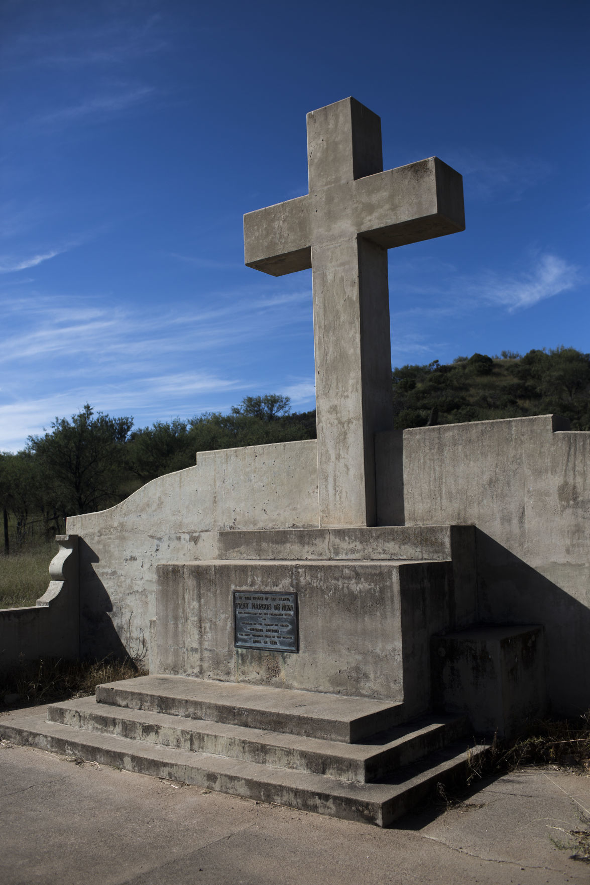
A monument in Lochiel marking where Fray Marcos De Niza entered Arizona Tuesday, Oct. 1, 2019.Tuesday, Oct. 1, 2019.
U.S. – Mexico border near Lochiel, Ariz.
Updated
Brothers Ramon and Ed De La Ossa mend fencing on their family's ranch in Lochiel after moving cattle Tuesday, Oct. 1, 2019. The ranch which used to span both sides of the U.S./Mexico border has been in the family for three generations.
U.S. – Mexico border near Lochiel, Ariz.
Updated
Ed De La Ossa mends fencing on his family's ranch in Lochiel Tuesday, Oct. 1, 2019. The ranch which used to span both sides of the U.S./Mexico border has been in the family for three generations.
U.S. – Mexico border near Lochiel, Ariz.
Updated
Ed De La Ossa moves cattle on his family's ranch in Lochiel Tuesday, Oct. 1, 2019.
U.S. – Mexico border near Lochiel, Ariz.
Updated
U.S. Customs inspector Helen Mills, right, greets Mexican counterpart Raymundo Aguirre Castillo at the U.S. - Mexican border station at Lochiel, Ariz., in 1979.
U.S. – Mexico border near Lochiel, Ariz.
Updated
The US Customs building, right, at Lochiel, Ariz., is just a short distance away from the international border in May 1972. For ten years, Mills has been managing the port of entry, which is mostly made up of five houses, a school and an vacant church, inspecting vehicles as they head into the US. During the week, from Monday through Saturday, Mills opens the border gate from 8 am to 10 am and from 4 pm to 6 pm. On Sunday the gate is open from 8 am to 6 pm. In that time barely a dozen vehicles make their way across the border but it is a major convenience to the local residents.
U.S. – Mexico border near Nogales, Ariz.
Updated
Pedestrians walk to the Nogales port of entry Tuesday, Oct. 1, 2019.
U.S. – Mexico border near Nogales, Ariz.
Updated
A pedestrian walks across North Grand Avenue in Nogales near the U.S./Mexico port of entries Tuesday, Oct. 1, 2019.
U.S. – Mexico border near Nogales, Ariz.
Updated
U.S. Customs and Border Protection officer R. Hernandez uses a density-measuring device on the rear quarter-panel of a Mexico-bound passenger vehicle at the DeConcini Port of Entry on Nov. 2, 2016, in Nogales, Ariz.
U.S. – Mexico border near Nogales, Ariz.
Updated
A Customs and Border Protection officer makes a visual check of a man's identification at the DeConcini Port of Entry on Feb. 15, 2017, in Nogales, Ariz. Busts of fraudulent border-crossing documents and the use of someone else's documents plummeted in Arizona and the rest of the border in the past decade.
U.S. – Mexico border near Nogales, Ariz.
Updated
Northbound commercial truck traffic lined up for inspection at the Mariposa Port of Entry on March 28, 2017, in Nogales, Ariz.
U.S. – Mexico border near Nogales, Ariz.
Updated
In the commercial lanes a semi truck stops between the lanes looking for the first available opening at the Mariposa Port of Entry in 2015.
U.S. – Mexico border near Nogales, Ariz.
Updated
Javier Castillo inspects a north-bound Mexican tractor-trailer at the Arizona Department of Transportation's inspection facility at the Mariposa Port of Entry on Sept. 19, 2017, in Nogales, Ariz. ADOT's International Border Inspection Qualification program, led by ADOT's Border Liaison Unit, teaches commercial truck drivers what to expect during safety inspections when they enter Arizona ports of entry.
U.S. – Mexico border near Nogales, Ariz.
Updated
A Border Patrol truck parked near the commercial port of entry in Nogales.
U.S. – Mexico border near Nogales, Ariz.
Updated
An illegal alien scales the U.S.-Mexico fence back toward Sonora after a Nogales Police Department officer, right, spotted him west of the Mariposa Port of Entry, Nov. 15, 2018, in Nogales, Ariz.
U.S. – Mexico border near Nogales, Ariz.
Updated
Kory's, a store catering to wedding, quincea–era and formal gowns, located at 15 N Morley Ave, Nogales, Ariz., sits katty corner to the Morley Gate Border Station on January 30, 2019.
U.S. – Mexico border near Nogales, Ariz.
Updated
Sun shines through the U.S.-Mexico bollard fence west of the Mariposa Port of Entry, Nov. 15, 2018, in Nogales, Ariz.
U.S. – Mexico border near Nogales, Ariz.
Updated
Children from Nogales, Sonora, climb through a hole in the international border fence to trick-or-treat in Nogales, Arizona, on Halloween in 1987.
U.S. – Mexico border near Sasabe and Lukeville, Ariz.
Updated
Border monument #166 is seen on the right as construction continues on the new 30-foot tall bollard fence that replaces old U.S./Mexico border fence two miles east of the Lukeville, Arizona port of entry on October 8, 2019. Photo taken from Sonoyta, Sonora, Mexico.
U.S. – Mexico border near Sasabe and Lukeville, Ariz.
Updated
Construction continues on the new 30-foot tall bollard fence along the U.S./Mexico border two miles east of the Lukeville, Arizona port of entry on October 8, 2019. Photo taken from Sonoyta, Sonora, Mexico.
U.S. – Mexico border near Sasabe and Lukeville, Ariz.
Updated
A Mexican worker rides his horse along a road south of the U.S./Mexican border wall on his way back into Sonoyta Wednesday, Aug. 28, 2019.
U.S. – Mexico border near Sasabe and Lukeville, Ariz.
Updated
New paneling of border wall seen about three miles east of the Lukeville/Sonoyta port of entry seen from the Mexico side of the border line Wednesday, Aug. 28, 2019.
U.S. – Mexico border near Sasabe and Lukeville, Ariz.
Updated
Old mesh paneling is removed in preparation for new wall to be built about three miles east of the Lukeville/Sonoyta port of entry seen from the Mexico side of the border line Wednesday, Aug. 28, 2019.
U.S. – Mexico border near Sasabe and Lukeville, Ariz.
Updated
A construction worker prepares cables to lift a piece of the 30-foot tall bollard fence along the U.S./Mexico border fence two miles east of the Lukeville, Arizona port of entry on October 8, 2019. Photo taken from Sonoyta, Sonora, Mexico.
U.S. – Mexico border near Sasabe and Lukeville, Ariz.
Updated
Border Patrol Officers to the side of a worksite about three miles east of the Lukeville/Sonoyta port of entry where new border wall is being installed seen from the Mexico side of the border line Wednesday, Aug. 28, 2019.
U.S. – Mexico border near Sasabe and Lukeville, Ariz.
Updated
Old wall east of the Lukeville/Sonoyta port of entry seen from the Mexico side of the border line Wednesday, Aug. 28, 2019.
U.S. – Mexico border near Sasabe and Lukeville, Ariz.
Updated
Raised wall east of the Lukeville/Sonoyta port of entry seen from the Mexico side of the border line Wednesday, Aug. 28, 2019.
U.S. – Mexico border near Sasabe and Lukeville, Ariz.
Updated
A work site east of the Lukeville/Sonoyta port of entry seen from the Mexico side of the border line Wednesday, Aug. 28, 2019.
U.S. – Mexico border near Sasabe and Lukeville, Ariz.
Updated
Normandy fencing placed against a section of border fence west of Lukeville Wednesday, Aug. 28, 2019.
U.S. – Mexico border near Sasabe and Lukeville, Ariz.
Updated
A semi passes by Quitobaquito Springs as it drives along Highway 2 in Mexico Wednesday, Aug. 28, 2019.
U.S. – Mexico border near Sasabe and Lukeville, Ariz.
Updated
An area referred to as "flood gate" along the U.S./Mexico border near Sasabe, Ariz. is on the list of the Department of Homeland Security’s priorities for building a border wall, but no funding has been allocated yet. September 16, 2019.
U.S. – Mexico border near Sasabe and Lukeville, Ariz.
Updated
Vehicle barriers mark the U.S./Mexico border within the Buenos Aires National Wildlife Refuge in Sasabe, Ariz. on September 16, 2019.
U.S. – Mexico border near Sasabe and Lukeville, Ariz.
Updated
A portion of the U.S./Mexico bollard border fence ends on the right and vehicle barriers begin within the Buenos Aires National Wildlife Refuge in Sasabe, Ariz. on September 16, 2019.
U.S. – Mexico border near Sasabe and Lukeville, Ariz.
Updated
A U.S. Customs and Border Protection Integrated Fixed Tower, left, near Sasabe, Ariz. on September 16, 2019.
U.S. – Mexico border near Sasabe and Lukeville, Ariz.
Updated
The new 30-foot tall bollard fence that replaced old U.S./Mexico border fence can be seen on the left. It's located about miles east of the Lukeville, Arizona port of entry on October 8, 2019. Photo taken from Sonoyta, Sonora, Mexico.
U.S. – Mexico border near San Luis, Ariz.
Updated
A US Border Patrol vehicle seen next to a section of new 30 foot high wall along the US/Mexico border near the commercial port of entry in San Luis Thursday, Aug. 8, 2019.
U.S. – Mexico border near San Luis, Ariz.
Updated
Old fencing is taken down along the United States/Mexico border seen from the northern end of San Luis, Mexico, Aug. 7, 2019.
U.S. – Mexico border near San Luis, Ariz.
Updated
A security guard stand in a construction site where a new fence will be placed on the United States/Mexico border seen from the northern end of San Luis, Mexico, Aug. 7, 2019.
U.S. – Mexico border near San Luis, Ariz.
Updated
Old fencing against new fencing along the United States/Mexico border seen from the northern end of San Luis, Mexico on Aug. 7, 2019.
U.S. – Mexico border near San Luis, Ariz.
Updated
Crews prepare ground for a new fence to be placed on the United States/Mexico border seen from the northern end of San Luis, Mexico on Aug. 7, 2019.
U.S. – Mexico border near San Luis, Ariz.
Updated
Vehicles in line to enter the United States from San Luis, Mexico on Aug. 7, 2019.
U.S. – Mexico border near San Luis, Ariz.
Updated
New fencing along the United States/Mexico border seen from the northern end of San Luis, Mexico on Aug. 7, 2019.
U.S. – Mexico border near San Luis, Ariz.
Updated
A new section of fencing on the U.S. - Mexico border in California, just west of Yuma, Ariz., in 1993.
U.S. – Mexico border near San Luis, Ariz.
Updated
Sand drifts through the "floating fence" that marks the border running through the dunes, Wednesday, July 25, 2018, west of San Luis, Ariz.
U.S. – Mexico border near San Luis, Ariz.
Updated
A sign warns of the dangers of trying to swim the All-American Canal just north of the Mexican border, Wednesday, July 25, 2018, west of San Luis, Ariz.
U.S. – Mexico border near San Luis, Ariz.
Updated
A long string of lights illuminate the no-man's land between the triple fencing of the Mexican border, Wednesday, July 25, 2018, San Luis, Ariz.
U.S. – Mexico border near San Luis, Ariz.
Updated
The border fence comes to an abrupt end at the currently dry Colorado River, Thursday, July 26, 2018, west of San Luis Rio Colorado, Sonora.