


Editor's note: This is the fifth of six stories for "Colorado River reckoning: Not enough water," an investigative series by the Arizona Daily Star that observes, at length, the future of the Colorado River.
Flows on the Colorado River, already crippled by warm, dry weather since the turn of the century, seem likely to get lower still in the coming decades.
Warming weather will continue to bring more evaporation and early melting of snowpack. It will keep drying out the river basin's soils, so they'll keep soaking up melted snow that otherwise would flow into the river and its tributaries.
And while it's not clear if the river basin will get more or less rain and snow over the coming decades than is falling now, even the extra precipitation won't be enough to counteract the impacts of continued warming weather.

Bonito Bend on the Colorado River between Labyrinth and Stillwater Canyons, from the John Wesley Powell expedition in 1871. About 150 years later, "We are in a period of warming and the climate is going places where we don’t have past experience. We’re doing an uncontrolled experiment on the Earth," says David Tarboton of Utah State University's Water Research Laboratory.
These are among the concerns raised by results of five recent studies. They suggest that continued declines in river flows could or will occur for as long as another 80 years, on top of a nearly 20% decline the river has suffered since 2000. A sixth study projects flows staying roughly at their post-2000 average from 2023 through 2060.
Such warm weather and diminished flows would make it more difficult than it already is for the federal government to keep Lakes Mead and Powell from falling so low that their accompanying dams can no longer generate electricity, or that they hit "dead pool," at which no water can be pulled from them.
One new study specifically warns that "considerable periods" lay ahead in which Powell could fall below its minimum power-generating level of 3,490 feet.
The seven Colorado River Basin states, including Arizona, are now enmeshed in tense negotiations to try to meet a U.S. Bureau of Reclamation directive to cut their take from the river by up to 28% by next year. Cuts of that scale likely will be enough to stabilize the reservoirs at or near their current elevations, if river flows stay at currently depressed levels, says a seventh recent study, this one from Utah State University's Center for Colorado Studies.
But if flows keep declining, states will have to curb their take from the river even more, said Kevin Wheeler, one of the Utah State study's co-authors and a University of Oxford senior research fellow.
That study, published in Science magazine, assumed an equal probability of the number of dry years occurring on the river with the number that occurred from 2000 to 2018, Wheeler said.
The problem is, the last few years on the river have been significantly drier than the average flows over the 23-year period of drought that began in 2000.
Since 2000, the river has averaged about 12.1 million acre-feet a year of flows at the federal gauging station at Lee's Ferry, just downstream of Glen Canyon Dam. That compares to a 20th century average annual flow of about 15 million acre-feet.
After more than a decade of construction, Glen Canyon Dam was officially dedicated by First Lady Ladybird Johnson on Sept. 22, 1966.
Since 2018, however, average annual flows have plunged to about 10.41 million acre-feet a year, or nearly 50% lower than in the 20th century. the second worst period for the river on record since Lake Powell started filling in the 1960s.
The worst-case scenarios for future flows identified in two of the recent studies would give the basin 7.4 million to 9 million acre-feet a year — numbers that Colorado climate scientist Brad Udall calls totally unsustainable.
"At 12 million since 2000, it’s not sustainable. At 9 million acre-feet, we'll need a complete rethink of who gets what water," said Udall, a native Tucsonan and a senior water and climate scientist at Colorado State University's Colorado Water Center.
"In my mind a permanent 9.4 million acre-foot flow is not going to happen for awhile, but what do I know? In the near term, you could easily see 9.4 million acre-feet for an extended period of time, a five- to seven-year period.
"This is a dangerous game of predicting what Mother Nature is going to throw at us."
Wheeler acknowledged that conditions could certainly become worse than those assumed by researchers on the paper he worked, if already warming temperatures keep increasing. A series of five or 10 years like the last three years, in particular, "would require larger reductions than we had simulated," he said.

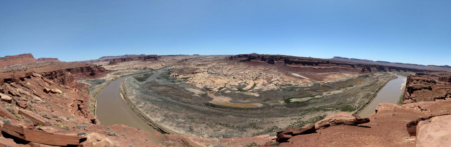
Several images combined show a panoramic view of the Colorado River where it runs through what once was Hite Marina on Lake Powell. Some studies foresee long periods of continued warm weather and diminished flows, raising worries the lake could hit "dead pool," at which no water could be pulled from it.
Imagine Rockies with SW weather
Of the recent studies, one from Los Alamos National Laboratory offers some of the most sweeping conclusions.
Published in April 2022, it predicted that by the end of the 21st century, continued warming will cause much of the wetter Upper Colorado River Basin to have less water and to more closely resemble the already arid Southwest's Lower Colorado River Basin. The study was published in the journal Earth and Space Science.
The authors found areas of Colorado, Utah and Wyoming — which today contribute most of the runoff to the Upper Colorado River feeding Lake Powell — could have much less water than today. Those states and New Mexico comprise the Upper Basin, while the Lower Basin includes Arizona, California and Nevada.
Using a form of artificial intelligence to analyze climate data, the study predicts spring snowmelt will disappear entirely in some sub-watersheds in the Upper Basin. Large snowpack losses will occur in others, particularly in higher elevation areas such as the Rocky Mountains, the study found.
More specifically, the study projects more arid conditions in the Green River Valley, near the borders of Utah, Colorado and Wyoming. That area includes the Flaming Gorge Reservoir, which has been a crucial recent source of river water to send downstream to prop up Lake Powell. Some mountainous areas in Arizona will also receive significantly less soil moisture, the study concluded.
Hotter temperatures will mean a lot more evapo-transpiration of snow into the air will occur, producing snowpack losses of up to 50% to 60% by 2099, said Katrina Bennett, a research scientist for the laboratory and one of the study's co-authors.
"That obviously translates to lower streamflow," Bennett said. "We saw lower soil moisture, especially in areas already dry, and that is indicative of this longer drought."
The study examined results of six computer models that estimated Colorado River Basin temperatures will rise by a range of 7.3 to 12.6 degrees Fahrenheit by the period 2079 to 2099, compared to 1970 to 1999. Of those six models, three showed increases in precipitation and three showed decreases.
The study also looked at other indicators of extreme drought, such as numbers of dry days, minimum soil moisture, maximum temperatures and evapo-transpiration figures and minimum runoff totals.
But whether the models predicted more or less precipitation, the ultimate outcome is, "we still see increased aridity, due to the increases in temperatures," said Bennett, a hydrologist.
Aridity is a term many scientists use as an alternative to drought. Drought typically implies a temporary lack of water, whereas aridity describes a long-term if not permanent change to a drier climate.
"As water cycles move through the system, if you have drier soils and increased evapotranspiration, that water, even if it’s falling in the form of precipitation, it simply runs off the landscape," Bennett said. "It falls in the summer as opposed to arriving in the system in winter as snowpack that can be released as snowmelt and is able to be absorbed into the groundwater system."
These future conditions are similar in some ways to conditions on the Colorado River today. For the past few years, average or near-average winter snowpack in the Upper Basin has translated to runoff well below normal, because the basin's increasingly arid soils soak up a lot of the snowpack, keeping it from reaching the river.
"But it's going to be more severe than now," Bennett said.
The study's computer modeling doesn't represent a crystal ball, laboratory officials noted.
"We observed significant uncertainty in drought behavior among the several climate models used," Bennett said.

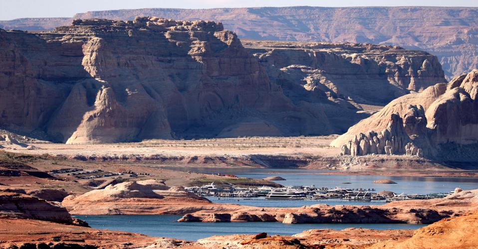
A view north from Wahweap Marina Overlook shows the shrunken waters in that part of Lake Powell near Page, Arizona. One new study warns "considerable periods" lay ahead in which Powell could fall below the level at which Glen Canyon Dam can generate electricity for its Western customers.
2nd century drought worse than ours
Two other recent studies looked at long-ago Colorado River droughts, using tree ring and other data, and found they were worse or much worse than today's drought.
The most dramatic finding came from a study that examined 2,000 years of Upper Basin tree ring records and other data. It found the lowest flows in that period came during the 2nd century, from 130 to 150. Besides tree ring data, the researchers used lake and cave sediments and sediments from bogs.
Historical river flow records have shown the current drought, measured from 2000 to 2021 but continuing today, is the worst on the Colorado since such records started being kept in 1906. Also, existing tree ring records show this period has had the lowest flows of any 22-year period dating back to 762, the study said.
Flows coming downriver from Lake Powell to Lake Mead since 2000 have averaged 84% of the river's average annual flow of 14.7 million acre-feet from 1906 to 2021.
Satellite imagery from Google Earth shows Lake Mead from 1984 to 2020. To see how the water body has changed over time, press the play button at the bottom of the image.
But from 129 to 150, the river only carried 68% of the 1906-2021 flows, or 10 million acre-feet a year, the study found.
This study's finding of worse conditions in the distant past is "alarming," Oxford researcher Wheeler said.
"This does suggest that the same conditions could reoccur anytime in the future, and with elevated CO2 and global temperatures than (there were) two millennia ago, this could occur with a greater frequency or magnitude," Wheeler said. "At the same time, we are in a new era of climate in which there is much we do not know, so periods of wetter years ahead certainly cannot be ruled out either."

Sightseers twenty or thirty feet above get photos of the low water levels of Lake Powell from the public boat ramp at Antelope Point Marina, Ariz.
In the 21st century, "it’s probably fair to say we could have a lower 22-year period of stream flows" than the 2nd century period, in part because of our warming temperatures, said Connie Woodhouse, a University of Arizona tree ring specialist and one of five-co-authors of this study. She is also a professor of geography and development and of dendrochronology.
The other authors work for UA, the U.S. Bureau of Reclamation, the U.S. Geological Survey and Northern Arizona University. The study was published in June in the journal Geophysical Research Letters.
"The tree-ring data support that this is within the realm of possibility," said Woodhouse of a longer future drought than in the 2nd century.
The gap between the second century's low flows and those since 2000 is "not a huge difference," she said.
But at the same time, the 2nd century's climate suggests we won't see an exact replica of those conditions today, Woodhouse said. Most important, climate records dating back thousands of years show a very slow wetting period over the last 2,000 or even 5,000 years, meaning the 2nd century had less precipitation than now, she said.
But also, today's climate is warmer than that of the 2nd century, she said.
"When we have a drought, it can be because there’s not much rain. But that can be exacerbated by warm temperatures and now we have decreases in flow not because we are not getting as much rain and snow," Woodhouse said. "It's because it’s warmer."
Looking back to look ahead
A study published in September by Utah State researchers took a similar tack, looking at tree-ring records of river flows over the past 600 years. The researchers then went a step farther, using those records to make future, drier flow projections.
"Guided by the idea that if it has happened in the past, it might happen again in the future, they found that future drought conditions could produce even lower flow conditions than the present drought," said a Utah State news release about the study. "This suggests the need for alternative management strategies for the Colorado River Basin."
Future scenarios indicate there could be "considerable periods" in which Lake Powell falls below the level at which its turbines can generate power, the study said.
That's "a critically low level for operation of the reservoir and supply of water" to the Lower Basin states.
The study looked specifically at three dry periods, ranging from 19 to 25 years long, dating from the 15th to the 20th centuries.
One lasted from 1576 to 1600, a second ran from 1953 to 1977, and a third covered most of the current drought period from 2000 through 2018. By far the worst period was the earliest, during which the river carried 11.76 million acre-feet a year from 1576 to 1600. That' almost 20% less water than the depressed flows recorded in the basin since 2000. The most recent dry period before now came from the 1950s to the 1970s, averaging 12.89 million a year.
The 11.76 million figure is "dire," said Professor David Tarboton, a study co-author and director of Utah State University's Water Research Laboratory. Looking at shorter periods in that time span, "you could get down maybe as low as 9 to 10 million acre-feet a year over 10 years," he said.
The co-authors included three Utah State researchers, one from Colorado State University and one from the University of Oxford. It was published by the Journal of the American Water Resources Association.
The researchers used climate computer models to project future river flows, based on records randomly selected from each drought period. They created 100 sets of low-flow scenarios for the river based on individual droughts. The scenarios are "extreme but plausible," Tarboton said.
Looking to 2060, the river could see average annual flows a little bit less or a little bit more than the 11.76 million figure, he said.
"While it is tempting to suppose that the current drought is an extraordinarily rare occurrence that should not evoke any permanent change, this research pushes back against that notion. Results suggest that the (water-saving) measures we now may think of as temporary may need to become permanent," the Utah State news release said.
Study: Possible flow decline of up to 41%
One of the few recent studies to make specific projections for how much water the river will lose due to climate change came out of the U.S. Geological Survey in early 2020.
It warned that just considering rising temperatures' impacts, river flows could drop 14% to 31% from 2036 through 2065 from an annual average flow of 14.8 million acre-feet from 1913 through 2017.
If precipitation is also considered, the range of impacts grows much wider, from a 3% increase to a 41% decrease over the same period. The range of possible flows is wider when precipitation is considered, because some computer models predict climate change will increase precipitation while others predict decreases. If the 41% decrease occurred over a long period, that could produce annual flows as low as 9 million acre-feet.
Looking strictly at the projections that consider precipitation and "given the drought you've been experiencing, one might tend to believe the more pessimistic climate models ... making the 41% decrease more credible than the 3% increase," said study co-author Christopher Milly, a just-retired USGS research hydrologist.
Milly called the prospect of a 9 million acre-foot river plausible although not the most likely outcome. Probably the most likely scenario lies between the extremes, he said.
But he said he would strongly recommend that public officials and water managers consider the possibility of annual flows as low as 9 million within the next 30 years.
"In this scenario, the new normal would be 9 million acre-feet, and things would be even drier in drought years," Milly said. "Furthermore, what's 'normal' would likely continue to decrease over subsequent decades."
"Those flows below 12 million acre-feet are going to continue to put this system in a really bad place. If it goes much lower than that, to 9-10-11 million-acre feet, it just speeds up the crash of the system," said researcher Udall, who wasn't part of this study.
ASU study is less pessimistic
A still unpublished although publicly discussed study from Arizona State University, among other parties, offers a bit more hope.
That study used computer models to project the river's annual average flow from 2023 through 2060 will be 12.39 million acre-feet. That's very slightly more than the river's average flow since 2000,while still representing a significant decline from the historic flow of 14.76 million acre-feet, from 1906 through 2019.
The study was financed by a $1.1 million grant from NASA, and the Central Arizona Project participated in the research with ASU.
"It’s clear that the amount of snow and soil water will decrease. The precipitation future is very variable. Some years it’s high, some years low," one of the study's co-authors, Arizona State University Professor Enrique Vivoni told a September CAP board meeting in Phoenix.
"The key message is no matter what we're having of years of high rainfall, it cannot offset the warming effect. The warming effect is here to stay. The Colorado River will have less water in the 21st century," said Vivoni, of ASU's School of Sustainable Engineering and the Built Environment.

Jake Quilter, an environmental advocate with the Glen Canyon Institute, walks down the newly cut banks of Clear Creek just outside the Cathedral in the Desert formation near the Utah border with Arizona. The sand is silt left behind by the receding waters of Lake Powell.
Plus, he pointed to the study's finding of a 10% chance that the annual river flow could average as little as 7.4 million acre-feet throughout the study period — less than half the river's historic average flow of the 20th century.
This forecast offers the river's "best case" scenario, noted Eric Kuhn, an independent water researcher and author.
"There’s no doubt we are currently within a dry cycle within a dry period. There's no doubt we are going to get some big winters, because climate change, it juices the atmosphere," said Kuhn, former general manager for the Colorado River District in Glenwood Springs, Colo.
"There’s also probably going to be some periods like we going through now, that are really dry for an extended period. In my view, if that study is right, if that happens, it would would be a good thing. It just means we have to cut a lot of water to survive at the river level we are at today."
Utah State's Tarboton said the 12.39 acre-foot forecast by the ASU-CAP study is entirely consistent with his study's scenarios.
But he wouldn't be surprised if annual flows fall below 12.4 million acre-feet even as soon as the next 20 years, he said.
"We are in a period of warming and the climate is going places where we don’t have past experience," he said. "We’re doing an uncontrolled experiment on the Earth."
Longtime Arizona Daily Star reporter Tony Davis talks about the Colorado River system being "on the edge of collapse" and what it could mean for Arizona.

Photos: The receding waters of Lake Powell, Glen Canyon National Recreation Area

Tom Wright hikes past the beached marker for Willow Canyon where it joins with the Escalante River, Glen Canyon National Recreation Area, Utah.

A big horn sheep stands with the moon as a backdrop, looking over Fiftymile Creek, Glen Canyon National Recreation Area, Utah.
Tom Wright walks through the shaft of light peeking through the narrow openings of the formation called the Subway in Fiftymile Creek, accessible since the waters of Lake Powell have fallen dramatically.

A narrow sliver of sky is visible overhead through the narrow opening of the formation called the Subway, Fiftymile Creek, accessible since the waters of Lake Powell have fallen dramatically.

The dark streaking, called Desert Varnish, is from the seepage of oxidation in the rocks, and is beginning to erase the "bathtub ring", the lighter colored marks left by the waters of Lake Powell on canyon walls, Fiftymile Creek, Glen Canyon National Recreation Area, Utah.

The remains of a small boat, underwater for years, reemerges due to receding water levels of Lake Powell in the Glen Canyon National Recreation Area, Utah.
Frank Colver makes his way over the dried and cracking silt left where the Escalante River joins Lake Powell, Glen Canyon National Recreation Area, Utah. The receding water of the lake has the river cutting through the decades of accumulated silt to form a delta where it meets the lake.

A warning buoy sits high and dry far from the end of the closed public boat ramp at Bullfrog Bay, Glen Canyon National Recreation Area.

A line of tires that were once breakwaters at Bullfrog Bay Marina are now stranded on the rocky landscape high above the current water levels at the Glen Canyon National Recreation Area, Utah.
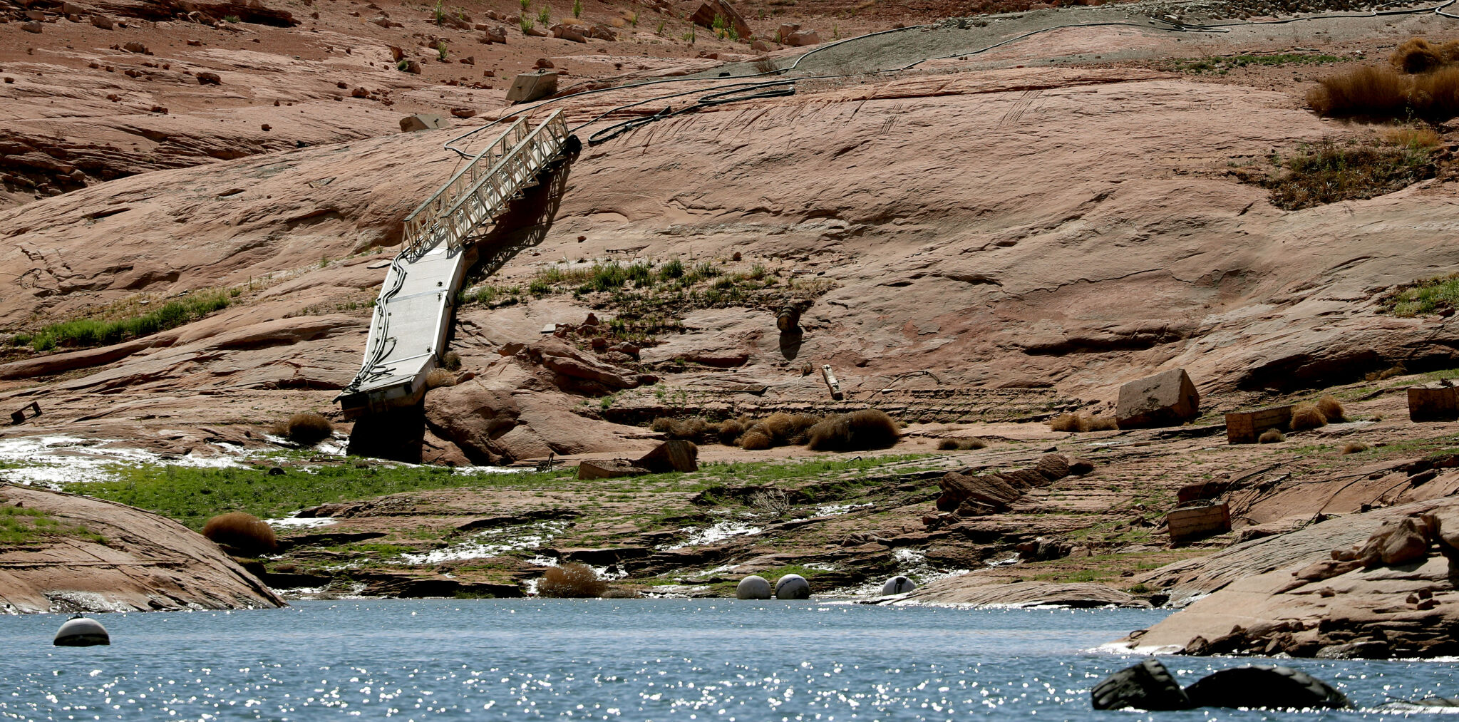
A pedestrian ramp lies well above the water levels at Bullfrog Bay in the Glen Canyon National Recreation Area, Utah.

A stranded wakeless zone buoy sits on the cracking silt outside the new shores of the Bullfrog Bay Marina, Glen Canyon National Recreation Area, Utah.

The end of the ferry ramp ends well short of the new water levels of Bullfrog Bay on the Glen Canyon National Recreation Area, Utah.

An early riser watches the sun come over the low waters of Bullfrog Bay Marina, Glen Canyon National Recreation Aria, Utah. The lighter colored areas on the canyon wall mark previous water levels.

A group of river rafters drift west on the current of the San Juan River outside Mexican Hat. The San Juan feeds Lake Powell.

The tops of a few cottonwood trees begin to poke out of shrunken water of Lake Powell, Fiftymile Creek, Glen Canyon National Recreation Area, Utah.

The remaining large water craft and house boats are crowded together in one of the last areas of water deep enough to support them at Wahweap Mariana, Glen Canyon National Recreation Area, Page, Ariz.

The waters of Lake Powell are twenty to thirty feet below the end of the public boat ramp at Wahweap Mariana, Glen Canyon National Recreation Area, Page, Ariz. Personal non-powered craft still use the ramp to unload, but must be carried up and down the banks to reach the water.

A view north from the Wahweap Marina Overlook show the shrunken waters around the marina in Glen Canyon National Recreation Area, Page, Ariz.

The underside of Gregory Natural Bridge, passable for the first time in almost 50 years, over the Fiftymile Creek, Glen Canyon National Recreation Area, Utah.

The moon rises over Gregory Natural Bridge, passable for the first time in almost 50 years, over the Fiftymile Creek, Glen Canyon National Recreation Area, Utah.

The exposed penstocks (intakes to the power turbines) on Glen Canyon Dam in the Glen Canyon National Recreation Area, Page, Ariz. The water level is at its lowest since 1967, when the dam was still being initially filled.

A group of sightseers get a look at the Glen Canyon Dam during a boat tour of Lake Powell, Glen Canyon National Recreation Area, Page, Ariz.

A small fishing boat ties up on the breakwater just outside the intakes for the Glen Canyon Dam, Glen Canyon National Recreation Area, Page, Ariz.. The penstocks (water intakes to the power turbines) are revealed for the first time since 1967 when the Lake Powell was being filled.

Swimmers and bathers use the jagged shores of the newly exposed banks of Lake Powell just above the Glen Canyon Dam, Glen Canyon National Recreation Area, Page, Ariz.

The Glen Canyon Bridge lies in front of electrical towers with feeder lines rising from the hydroelectric plant in the Glen Canyon Dam, Page, Ariz.

Glen Canyon Dam from Glen Canyon Bridge, Page, Ariz.

Small power boats on the Colorado River head upstream just below the Glen Canyon Dam, Page, Ariz.

Wade Quilter walks through the remains of cottonwood and Russian olive trees washed down and joined with silt to form a natural dam where Willow Canyon joins with the Escalante River, Glen Canyon National Recreation Area, Utah,

The remains of a big mouth bass lay in the silt just above where the Escalante River joins Lake Powell, Glen Canyon National Recreation Area, Utah.

The formation known as The Cathedral in the Desert on Clear Creek, Glen Canyon National Recreation Area, Utah. The re-emergence of the formation is drawing sightseers after being submerged for some 50 years.

Tom Wright feels the water oozing from the rocks in the formation known as Cathedral in the Desert on Clear Creek, Glen Canyon National Recreation Area, Utah. The re-emergence of the formation is drawing sightseers after being submerged for some 50 years.

Frank Colver takes a quiet moment and plays a handmade flute near the waterfall in the formation known as Cathedral in the Desert on Clear Creek, Glen Canyon National Recreation Area, Utah. The re-emergence of the formation is drawing sightseers after being submerged for some 50 years.

Jake Quilter walks down the newly cut banks of Clear Creek just outside Cathedral in the Desert, Glen Canyon National Recreation Area Utah. The sand is silt left behind by the receding waters of Lake Powell.

The tops of cottonwood trees that used to be under a hundred feet of water in Lake Powell are visible again in Clear Creek, Glen Canyon National Recreation Area, Utah. The deep water preserved the remains of the trees.

Boaters have to zig-zag through the rocks emerging due to receding waters of Lake Powell, Glen Canyon National Recreation Area, Page, Ariz.

Several images combined for a panoramic view of the Colorado River where it runs through the what once was Hite Marina in the Glen Canyon National Recreation Area, Utah.

A couple of sightseers take in the view from Hite Overlook over the Colorado River and the closed Hite Marina, Glen Canyon National Recreation Area, Utah.

Lone Rock, jutting out of the dry bed, would usually be surrounded by Lake Powell but is now well clear of the water, Glen Canyon National Recreation Area, Utah.

Tires that used to hold the lines well below the surface of Lake Powell are suspended over the water at Antelope Point Marina, Ariz.

Sightseers twenty or thirty feet above get photos of the low water levels of Lake Powell from the public boat ramp at Antelope Point Marina, Ariz.

The pedestrian access ramp ends abruptly twenty feet over the new Lake Powell surface at Antelope Point Marina, Ariz.

The entrance to the pedestrian access ramp of the Antelope Point Marina is taped off after being cutoff from the docks due to receding waters of Lake Powell.

