


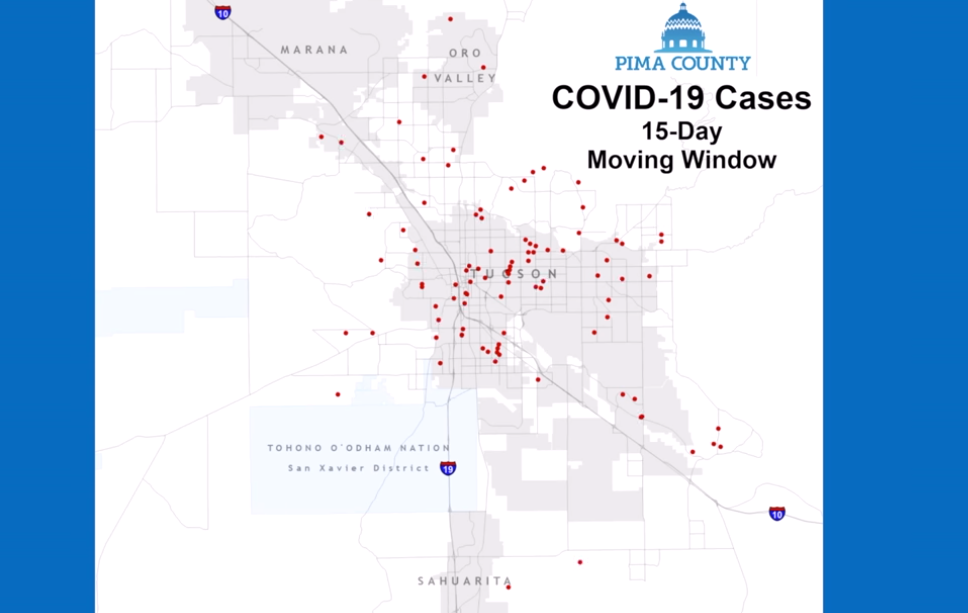
Pima County released a map Wednesday showing the approximate location of positive COVID-19 tests to show how the virus has spread throughout the Tucson community.
A dot on the map represents each case and those dots drop off after 15 days to show the community-wide spread based on a 15-day infection period, the Pima County Health Department said in a Facebook post.
The first dot appears on February 22, on the far southwest side of the county. A second case appears two days later in Tucson's south side.
From there, several more cases start to appear all over the map, covering almost every populated area in Pima County with the exception of the two Indian reservations in southwest Tucson.
Pima County released a map Wednesday showing the approximate location of positive COVID-19 tests to show how the virus has spread throughout the Tucson community.
The map includes a disclaimer saying the cases on the map include 1,086 out of 1,136 cases not located on Indian reservations. They are based on home addresses and cover test collection dates through April 24.
As cases on the map start to disappear, they don't seem to make much of a difference on the amount of cases across the county, meaning, the drop off of cases is minimal compared to the overall number of cases.
More information and resources to help during the COVID-19 pandemic in Pima County can be found at pima.gov/COVID19.
Photos for April 23: Tucson gets by during Coronavirus Pandemic
Tucson, coronavirus
Updated
Erika Munoz, owner of Seis Kitchen, hands over a bag of meals to Michael Gallagher Carondelet, a registered nurse at St. Joseph's Hospital, to distribute to other nurses and hospital workers, on April 23, 2020. The donation was made in conjunction with A+C (Athletes/Artists+Causes) Foundation's “Project Frontline.” In two deliveries, 400 meals (200 poc chuck chicken and 200 puerco verde burritos) will be given to medical personnel at Carondelet St. Joseph’s Hospital. The particular donation was made possible by the Houston Astros' Pitching Coach Brent Strom, who lives in Tucson.
Tucson, coronavirus
Updated
Hospital workers wheel in carts full of catered meals donated by Seis Kitchen to Carondelet St. Joseph's Hospital, on April 23, 2020. The donation was made in conjunction with A+C (Athletes/Artists+Causes) Foundation's “Project Frontline.” In two deliveries, 400 meals (200 poc chuck chicken and 200 puerco verde burritos) will be given to medical personnel at Carondelet St. Joseph’s Hospital. The particular donation was made possible by the Houston Astros' Pitching Coach Brent Strom, who lives in Tucson.
Tucson, coronavirus
Updated
Kristi Hall, a sixth grade teacher at Desert Sky Middle School, participates in planning a lesson with a fellow teacher on Zoom, at her home on April 17, 2020. Schools in the Vail School District are supposed to open in July due to their year-round school calendar. Plans are being made for the possibility of students returning to the physical classroom.
Tucson, coronavirus
Updated
Bry Kelley, a warehouse assistant, places a pallet filled with food down next to other items donated to the Community Food Bank of Southern Arizona on on April 21, 2020. Forty-one thousand pounds of flour, pasta and canned goods were donated by The Church of Jesus Christ of Latter-day Saints. The donation is part of an ongoing global effort by the church to address immediate needs of people and orgainzations due to the coronavirus disease (COVID-19) pandemic.
Tucson, coronavirus
Updated
A pallet of food is placed down next to other items donated to the Community Food Bank of Southern Arizona on on April 21, 2020. Forty-one thousand pounds of flour, pasta and canned goods were donated by The Church of Jesus Christ of Latter-day Saints. The donation is part of an ongoing global effort by the church to address immediate needs of people and orgainzations due to the coronavirus disease (COVID-19) pandemic.
Tucson, coronavirus
Updated
Christian Bergman, 4th year University of Arizona medical student, takes the temperature of a patient outside the Z Mansion, 288 N. Church Ave., in Tucson, Ariz., on April 19, 2020. Medical students from the University of Arizona and other universities volunteer to help the homeless population with the growing concerns of Coronavirus Disease (COVID-19) within the homeless population. “This is a vulnerable population in our community; they can’t defend themselves in a society already running short on supplies and resources,” said Bergman. Medical students and medical personal help by giving out food, drinks with electrolytes and masks to the homeless. Those who are sick, medically impaired or have been exposed to those with COVID-19 are isolated outdoors in tents on the property. As of Sunday April 19, there were 13 individuals whom are isolated in tents.
Tucson, coronavirus
Updated
Lekha Chesnick, 1st year medical student at Burrell College of Osteopathic Medicine, talks with a homeless man (whom choose to not give his name) outside of the Z Mansion, 288 N. Church Ave., in Tucson, Ariz., on April 19, 2020. Medical students from the University of Arizona and other universities volunteer to help the homeless population with the growing concerns of Coronavirus Disease (COVID-19) within the homeless population. Medical students and medical personal help by giving out food, drinks with electrolytes and masks to the homeless. Those who are sick, medically impaired or have been exposed to those with COVID-19 are isolated outdoors in tents on the property. As of Sunday April 19, there were 13 individuals whom are isolated in tents.
Tucson, coronavirus
Updated
Christian Bergman, 4th year University of Arizona medical student, checks on a patient outside the Z Mansion, 288 N. Church Ave., in Tucson, Ariz., on April 19, 2020. Medical students from the University of Arizona and other universities volunteer to help the homeless population with the growing concerns of Coronavirus Disease (COVID-19) within the homeless population. “This is a vulnerable population in our community; they can’t defend themselves in a society already running short on supplies and resources,” said Bergman. Medical students and medical personal help by giving out food, drinks with electrolytes and masks to the homeless. Those who are sick, medically impaired or have been exposed to those with COVID-19 are isolated outdoors in tents on the property. As of Sunday April 19, there were 13 individuals whom are isolated in tents.
Tucson, coronavirus
Updated
Elliott Dumont, owner of Roadrunner Bicycles, 6177 E. Broadway Blvd., works on a customer's bike on April 22, 2020. The coronavirus disease (COVID-19) has not slowed down bike shops. With many people at home, they are bringing bicycles for repairs and buying new ones for exercise. Dumont says he's booked out till the first week of May for tuneups on bikes.
Tucson, coronavirus
Updated
Elliot DuMont, owner of Roadrunner Bicycles, 6177 E. Broadway Blvd., far left, helps Ethan Sasz, far right, and his son, Evan, 10, with a mountain bike purchase on April 22, 2020. The coronavirus disease (COVID-19) has not slowed down bike shops. With many people at home, they are bringing bicycles for repairs and buying new ones for exercise. Dumont says he's booked out till the first week of May for tuneups on bikes.
Tucson, coronavirus
Updated
Marcella Montoya waits in her vehicle as general manger David Kessler brings out her order, as Bear Canyon Pizza serving their customers despite COVID-19 restrictions, April 22, 2020, Tucson, Ariz.
Tucson, coronavirus
Updated
Kitchen manger Koa Hoffmann tosses dough while working up a crust for a call-in order as he and few others keep cooking at Bear Canyon Pizza despite COVID-19 restrictions, April 22, 2020, Tucson, Ariz.
Tucson, coronavirus
Updated
Alvaro Enciso, a local artist, works in one of his studios at his home on April 9, 2020. Every Tuesday Enciso travels into the Sonoran desert to post crosses where migrants have died after crossing illegally over the U.S./Mexico border as part of a project he's titled Donde Mueren Los Suenos / Where Dreams Die. With the outbreak of the coronavirus disease his six year project is on hold and instead he works on other artwork at home.
Tucson, coronavirus
Updated
Dolly Spalding works on a pen and ink drawing in her apartment at the Redondo Tower Apartments on April 7, 2020. During her quarantine, Spalding has been creating drawings of all the Greek goddesses. She is collaborating with Emlyn Boyle, an artist from Ireland, and plans to publish a book with Boyle's writings.

