

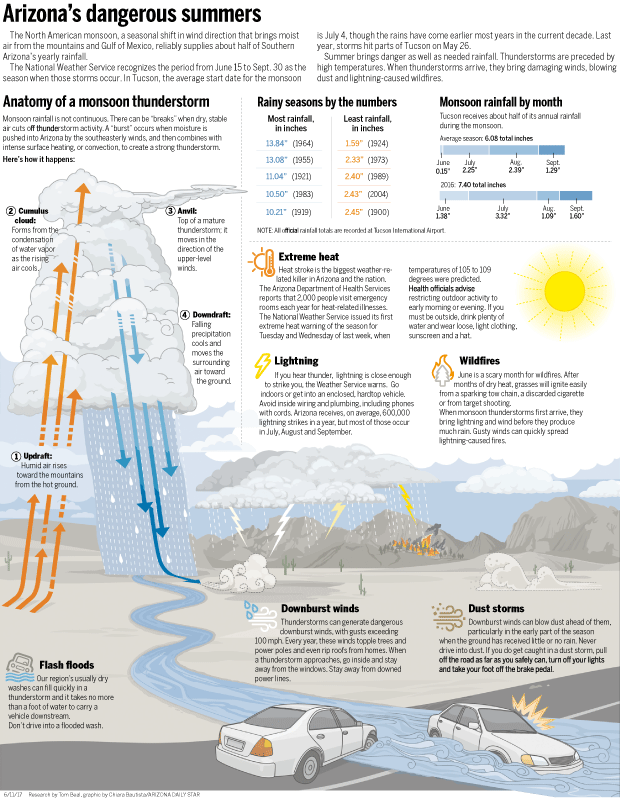
It’s time again for the summer weather forecast in Tucson: hot, then hotter, then hot and muggy followed by dangerously stormy.
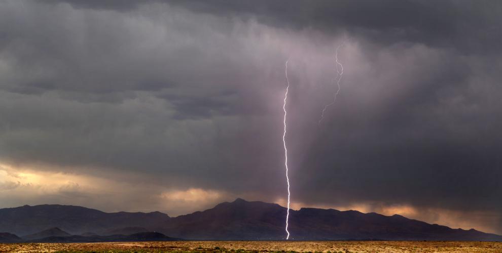
The monsoon — a seasonal shift in wind patterns — reliably brings Tucson half its annual rainfall in dramatic rounds of thunderstorms, whose location and intensity is notoriously difficult to predict.
The official National Weather Service monsoon season begins Thursday, June 15, but the meteorologists won’t hazard a guess about when the summer rains will arrive or how prolific they may be.
The National Climate Prediction Service looked at a half-dozen models to conclude that there are equal chances of above-average, below-average and average precipitation this summer, said Glenn Lader of the Tucson office of the National Weather Service in his monsoon preview.
Climatologist Mike Crimmins, in his monthly podcast for the University of Arizona’s CLIMAS website, fell back on climate data to boldly predict an average monsoon that will start July 4 or so.
Last week, as days of triple-digit high pressure yielded to moist air and a series of thunderstorms southeast of Tucson, it almost seemed the monsoon had arrived early.
Emily French of the NWS in Tucson said Thursday that the storms that started wildfires in Cochise County and dropped up to an inch of rain in southeastern Pima County on Wednesday do not count.
“That was a little bit of a false start,” French said. Official monsoon precipitation falls between June 15 and Sept. 30. “We’ll usually have one or two of these false events.”
“You can get patterns in May and June that are ‘monsoon-like’ for sure, and certainly this week was like that,” said atmospheric scientist Christopher Castro.
Castro, a UA associate professor of atmospheric sciences, has studied the North American Monsoon for 17 years.
He said these early bouts of thunderstorms “tend to be more dry thunderstorms associated with lightning and heavy downburst winds as the precipitation evaporates into the dry air. Those are ideal conditions to both trigger and spread wildfire.”
The most critical period for wildfires in Arizona is now until the actual monsoon shift that saturates the atmosphere and dampens fire spread.
For that to happen, said Castro, the high pressure that brings us such hot June temperatures needs to move north, setting up a “so-called monsoon ridge.”
That allows moist air from the south to stream into the region, where the mountain ranges act like thunderstorm factories, convecting that moist air into the upper atmosphere and forming the storm clouds that can blow off into the valleys.
Where that moist air comes from is still a subject of debate, Castro said.
“If it’s remote, it’s coming from oceanic sources in the Gulf of California and the Gulf of Mexico. The traditional perspective is that the upper-level moisture mainly comes from the Gulf of Mexico, but the lower level can come from the Gulf of California and the Pacific.”
Once the mountains begin receiving rain, they too, become a factor, Castro said.
“We really don’t understand, still, the effect of rapid green-up of vegetation. That becomes more important during the latter part of the monsoon.”
The monsoon’s arrival, whenever it occurs, decreases the fire danger, but brings other perils with it.
Last year, it hit Tucson early. A wet microburst dumped 3 inches of rain on midtown June 26, flooding streets and knocking down trees and power lines with winds up to 70 mph.
No rain is in the immediate forecast, French said. Temperatures should moderate beginning Sunday, with highs back in the double digits. Higher heat returns later in the week.
“We need that heat to get the monsoon moisture up here and start cranking out thunderstorms,” French said.

