


It began with a lightning strike on a parched mountainside above Oro Valley one year ago Saturday.
Over the next seven weeks, the Bighorn Fire consumed almost 120,000 acres, the largest blaze ever recorded in the Catalina Mountains or anywhere else in Pima County.
It took more than 1,000 wildland firefighters to contain the windblown flames in a landscape baked by record heat and crushing drought. Hundreds of residents were chased from their homes on and around the mountain, but not a single building burned.
A year later, the air tankers and Hotshot crews have been replaced by researchers, who have fanned out across the Catalinas to see how the landscape is recovering and how much more punishment it can take.
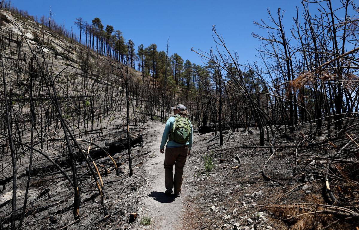
University of Arizona research scientist Jim Malusa spent three days last week hiking through some of the hardest hit areas.
His 15-mile trek to see what he called “the worst of the burn” took him 4,300 vertical feet down the northside of Mount Lemmon to the headwaters of the Cañada del Oro and back up again along Red Ridge. The same area was also severely burned during the Aspen Fire in 2003.
Along the way, Malusa sought out “photo points” where he could match old pictures of the forest — one of his, maybe, or something from the internet — to what the landscape looks like now, one year to the day that the Bighorn Fire began.
The trails he walked remain closed to the general public due to the risk of flash floods and falling debris. “This is easily the most burned up part of the mountain and also the hardest to get to — only trail access and it’s a long way down,” he said. “It takes effort to get down there.”
The Bighorn Fire in June-July, 2020, burned through the Santa Catalina Mountains. Video produced by Rick Wiley / Arizona Daily Star
The vegetation ecologist with the UA School of Natural Resources and the Environment made the trip on behalf of the Coronado National Forest and the Pima County Regional Flood Control District, which wanted to know what the burn scar looked like one year later.
The answer depends on what was growing there before the fire and how badly it burned, Malusa said.
In one of his before-and-after pictures, looking down toward Romero Canyon, you can see a transition in progress: the remnants of pine trees destroyed by the Aspen Fire, opening the ground to a thorny, fire-adapted shrub called Fendler’s ceanothus and eventually oak.
“Now the oaks are scorched, but they are very quickly resprouting,” Malusa said. “Even with last year’s miserable monsoon, they still have the resources to come back.”
Another photo shows a different patch of silverleaf oak that burned last year but now sports 3 to 4 feet of new growth.
“You’re looking at pictures here that are examples of quick recovery and resilience in an ecosystem,” he said. “You can’t believe how quickly it goes back to looking like it was before.”

The Bighorn Fire breaks onto the southern slopes of the Santa Catalina Mountains and burns over a pair of homes in the foothills just west of the Finger Rock Trailhead last year.
But that isn’t true of all plants or places.
Near one photo point, along the trail to Shovel Springs, Malusa snapped a picture of a Douglas fir that burned at the roots and toppled over last year. The tree was 4 feet across and more than 100 feet tall, and it had lived on the mountain above Tucson for several hundred years.
“Fire is very capricious. Sometimes it picks out all the small things … but sometimes it picks the grandpas and grandmas,” he said. “That’s what happens with these Doug firs a lot. These magnificent old trees, they look like they’re armored, but they’re not.”
Fire then flood
Some of the worst damage and biggest surprises Malusa saw came along the west fork of the Cañada del Oro.
The creek runs year-round there, giving rise to an unusual stand of trees. Douglas fir don’t usually grow so low on the mountain, but the combination of permanent water and a north-facing slope allowed them to take hold.
“It was a very diverse and lovely place,” Malusa said, right up until June 17, when a wall of flame roared up the canyon. “It all went in that one day. It was like a volcano on the mountain,” he said.
Even there, though, life goes on.
“This is poison ivy, which is really not what I expected,” Malusa said, pointing at a picture of leafy green plants erupting from the rocky bottom of the canyon. He also saw geraniums, another deep forest plant not common to a canyon like that, particularly after a high-severity fire.

A heavy-lift helicopter passes through the Bighorn Fire burning along Pusch Ridge in Coronado National Forest north of Tucson on June 6, 2020.
“That’s what keeps scientists going: Always being reminded with every trip that you don’t know nothing,” he said.
At first, Malusa was encouraged by the amount of new growth he saw in CDO canyon. Where there used to be “just sticks,” roughly 25% percent of the ground is now covered, mostly by silverleaf oak.
Then he spoke to a hydrologist, who told him that the chances of a serious slope failure are still high, despite the addition of those young sprouts. There’s only so much a few oaks can do for a canyon raked by intense fire twice in 20 years.
Braced for impacts
The Pima County Regional Flood Control District wanted Malusa up on the mountain to help predict what might come down.
The verdict: There hasn’t been enough rain since the fire to move much of the debris up there or spur enough growth to heal the watershed.
Officials believe there is still a huge risk of flash floods and landslides from the hardest hit areas.
“It’s almost like that year hasn’t passed,” said Brian Jones, who heads up the district’s floodplain management division. “We’re definitely in the mode of preparing for significant impacts.”

Keith Lencke of the Blue Ridge Hotshots watches the air attack on the Bighorn Fire in the Cobblestone Estates neighborhood near the Santa Catalina Mountains on June 11, 2020.
Later this month, the district will send out informational postcards to the owners of almost 1,000 homes and businesses considered at risk of flooding from the Bighorn Fire.
The Cañada del Oro, Pima Wash, Finger Rock Wash and Ventana Wash seem to pose the greatest threats, Jones said.
The agency will soon start work on improvements to the culverts that carry Pima Wash underneath Ina Road. The roughly $80,000 project was launched after computer models showed how increased runoff from the burn scar could overwhelm the current structure, sending water over the road and down into neighborhoods and businesses to the southwest.
A contractor has been hired for the job, but the work can’t start until the district gets approval for a federal grant to pay for it. “We’re pushing it a little close,” Jones said, but they hope to have the project finished before the heaviest rains arrive.
In anticipation of trouble on the CDO, district crews have been cleaning out and shoring up the channel wherever possible. “We want to give it as much room as we can give it so it doesn’t come out of its banks,” Jones said.
The district has also tried to get a jump on work elsewhere in the county so it will have plenty of resources available this summer in the event of an active storm season over the Catalinas.
That was one good thing about last year’s disappointing monsoon, Jones said: “It gave us a chance to get ahead of the game.”
Rating resilience
Malusa’s work is part of a larger scientific collaboration aimed at predicting the future of Southern Arizona’s most visited mountain and other sky islands like it.
“We are interested in whether forests will be resilient to things like wildfires and climate change,” said Don Falk, a fire ecologist and UA professor of natural resources.

Dark smoke from the Bighorn Fire in the upper elevations of Pima Canyon obscures the rising sun above the Santa Catalina Mountains in Coronado National Forest last year.
Those things are connected, because climate change is making winters warmer and drier and extending the length of fire seasons, he said. Meanwhile, the same hot, dry conditions that make fires more likely to start can also reduce the success rate of seedlings, slowing post-fire recovery.
To chart changes to the landscape, Falk and his team are revisiting scientific plots set up all over the mountain by other researchers dating back as far as the 1980s. There are 80 plots in all across a range of different plant communities. Some are in areas that also burned in 2003, 2002 or both.
Field work just got underway on the project, which is being led by UA graduate student Emily Fulé and researcher Rebecca Beers.
“We’re looking at the ecological impacts of the Bighorn Fire and the impact of reburns,” Fulé said on Wednesday, during an informational webinar hosted by the university’s Arizona Institutes for Resilience.
Understanding how our mountain ecosystems respond to fire and other stresses should help in the development of management strategies to make them more resilient, she said.
People assume all 119,978 acres within the Bighorn burn area were reduced to ash, Falk said, but large swaths of forest were unburned or saw only low intensity fire activity.
“Much of the mountain is already starting to recover,” he said.

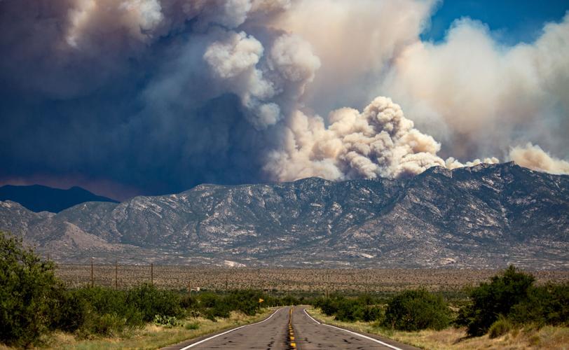
Smoke billows from the Santa Catalinas as the Bighorn Fire continues to burn as seen from Highway 79, on June 17, 2020.
Transition zone
According to estimates by the U.S. Forest Service, less than one-third of the land within in the fire perimeter sustained even moderate burn damage, while just 4% burned hot enough and long enough to consume almost all plants and litter, char roots and fuse the soil into a water resistant shell.
Recovery time in such high severity burn areas can be significant, especially in conifer forests where trees sprout from seeds.
Falk said it’s impossible to say how long it will take for the Catalinas to heal, because the landscape and the damage are both so variable. A patch of forest with moderate damage might show few scars from the fire a decade from now. A high severity burn area might not recover for 100 years or more.
And some areas won’t come back at all. They will be “reorganized” instead, Falk said. What was there before will be replaced by something else — a shrubland where a forest used to be — in a process known as type conversion.
“The whole place will look different, but it will still be an ecosystem. It will still be habitat for wildlife,” he said. “The birds will still be singing, even if they’re singing in a different forest.”
In some circles, this qualifies Falk as an optimist. He said several of his colleagues have a bleaker view of where the Catalinas are headed, but he believes “there is a future for these mountains.”
All that’s required is some additional forest management and a serious, global campaign to curb the human causes of climate change, Falk said. “I think we should be clear-eyed about what needs to be done and get down to the business of doing it.”

The Bighorn Fire burning along Pusch Ridge in Coronado National Forest north of Tucson on June 6, 2020.

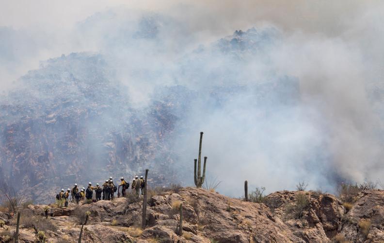
A Hotshot fire crew fighting the Bighorn Fire hikes on ridge near Finger Rock Canyon in the foothills of the Santa Catalina Mountains on June 11, 2020.
The Bighorn Fire in photos
A look back at the Bighorn Fire in photos
Bighorn Fire in the Santa Catalina Mountains, 2020
Updated
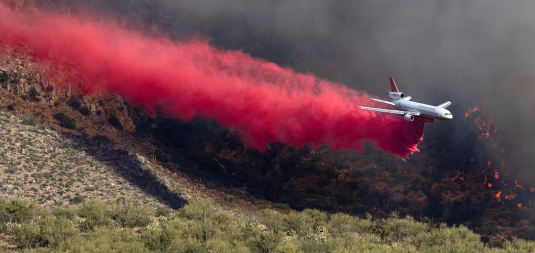
A DC-10 air tanker or VLAT (Very Large Air Tanker) dumps thousands of gallons of retardant on the Bighorn Fire burning along Pusch Ridge in Coronado National Forest east of Rams Canyon subdivision on June 6, 2020.
Bighorn Fire - Arizona
Updated
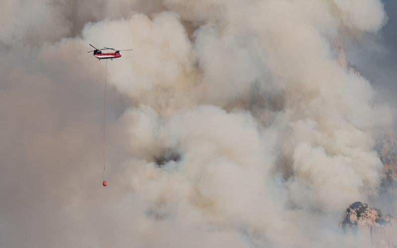
A Chinook heavy lift helicopter passes smoke from the Bighorn Fire burning along Pusch Ridge in Coronado National Forest north of Tucson on June 6, 2020.
Bighorn Fire in the Santa Catalina Mountains, 2020
Updated
Smoke from the Bighorn Fire shrouds granite formations of Pusch Ridge in Coronado National Forest north of Tucson on June 6, 2020.
Bighorn Fire - Arizona
Updated
People watch the aerial ballet of helicopters and air tankers on the Bighorn Fire from the safety of Oro Valley Marketplace on June 7, 2020.
Bighorn Fire - Arizona
Updated
A DC-10 air tanker spreads a line of retardant high atop Pusch Ridge as fire managers tried in vain to keep the the Bighorn Fire confined to the West end of the Santa Catalina Mountains in Coronado National Forest north of Tucson on June 6, 2020.
Bighorn Fire - Arizona
Updated
The Bighorn Fire burning above Catalina State Park in the Santa Catalina Mountains in Coronado National Forest north of Tucson on June 7, 2020.
Bighorn Fire - Arizona
Updated
Dark smoke from the Bighorn Fire in the upper elevations of Pima Canyon obscures the rising sun above the Santa Catalina Mountains in Coronado National Forest north of Tucson on June 9, 2020.
Bighorn Fire in the Santa Catalina Mountains, 2020
Updated
A helicopter dips into Rose Canyon Lake for water while fighting the Bighorn Fire still burning in the west end fo the Santa Catalina Mountains on June 9, 2020.
Bighorn Fire - Arizona
Updated
The Bighorn Fire consumes thick vegetation in crags above Pima Canyon within the Santa Catalina Mountains in Coronado National Forest north of Tucson on June 9, 2020.
Bighorn Fire in the Santa Catalina Mountains, 2020
Updated
A Chinook helicopter drops a load of water on the Bighorn Fire as is moves into the top of Finger Rock Canyon and up Mount Kimball, on June 10, 2020.
Bighorn Fire in the Santa Catalina Mountains, 2020
Updated
The Bighorn Fire burns up into juniper, mesquite and heavier fuel as it approaches Mt. Kimball in the Santa Catalina Mountains, Tucson, Ariz., June 10, 2020.
Bighorn Fire - Arizona
Updated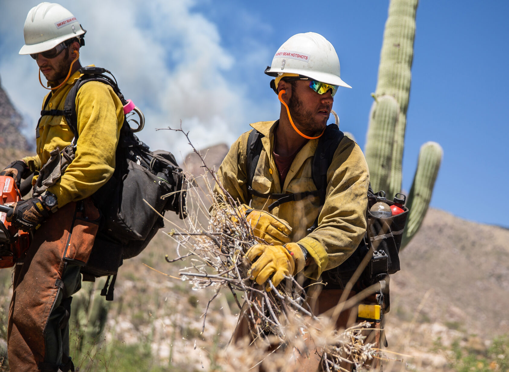
Adam Hutton with the Smokey Bear Hotshots of Ruidoso, New Mexico tosses away brush being cut near the mouth of Finger Rock Canyon as a precaution against the growing Bighorn Fire being fought in the Santa Catalina Mountain Range, on June 10, 2020.
Bighorn Fire in the Santa Catalina Mountains, 2020
Updated
The Bighorn Fire breaks onto the southern slopes of the Santa Catalina Mountains and burns over a pair of homes in the foothills just west of the Finger Rock Trailhead, Tucson, Ariz., June 10, 2020.
Bighorn Fire - Arizona
Updated
The Bighorn Fire churns through brush, creating a smoky mess in Pima Canyon and Finger Rock Canyon in the Santa Catalina Mountains north of Tucson on June 11, 2020.
Bighorn Fire in the Santa Catalina Mountains, 2020
Updated
A DC-10 air tanker (VLAT) drops fire retardant behind homes in the Cobblestone Estate during the Bighorn Fire in the Santa Catalina Mountains on June 11, 2020.
Bighorn Fire in the Santa Catalina Mountains, 2020
Updated
Residents watch a Neptune Aviation air tanker drop fire retardant behind the Santa Catalina foothills north of Tucson, Ariz. on June 11, 2020.
Bighorn Fire - Arizona
Updated
A hot shot fire crew hikes a ridge near Finger Rock Canyon in the Santa Catalina Mountains during the Bighorn Fire on June 11, 2020.
Bighorn Fire in the Santa Catalina Mountains, 2020
Updated
Keith Lencke of the Blue Ridge Hotshots watches the air attack on the Bighorn Fire in the Cobblestone Estates neighborhood in the Santa Catalina foothills on June 11, 2020.
Bighorn Fire in the Santa Catalina Mountains, 2020
Updated
Qin Chen talks with Tom Lemmons of the Pima County Sheriff's Office Auxiliary, about "Go" orders given to evacuate her home in the Cobblestone Estates neighborhood due to the Bighorn Fire in the Santa Catalina Mountains on June 11, 2020.
Bighorn Fire in the Santa Catalina Mountains, 2020
Updated
A Chinook helicopter dumps water on a slope during the Bighorn Fire in the Santa Catalina Mountains on June 11, 2020. Pinkish-red fire retardant coats the rock faces of the mountain range.
Bighorn Fire - Arizona
Updated
A DC-10 air tanker (VLAT) drops a line of retardant on a ridge above homes east of Pima Canyon in the Santa Catalina foothills during the Bighorn Fire on June 11, 2020.
Bighorn Fire in the Santa Catalina Mountains, 2020
Updated
A DC-10 VLAT makes a final drop in the fading light over the homes in the area between Swan and Alvernon during the daylong struggle to keep the Bighorn Fire out of the neighborhoods of the Santa Catalina Mountain foothills, Tucson, Ariz., June 11, 2020.
Bighorn Fire in the Santa Catalina Mountains, 2020
Updated
People watch from Oracle Road just north of the entrance to Catalina State Park as Chinook helicopters drop water on the Bighorn Fire which is burning for its seventh day in the western Santa Catalina mountain range, on June 12, 2020.
Bighorn Fire in the Santa Catalina Mountains, 2020
Updated
Smoke billows from the Bighorn Fire burning in the Pusch Ridge Wilderness, on June 12, 2020.
Bighorn Fire in the Santa Catalina Mountains, 2020
Updated
Two firefighting helicopters maneuver around one another while recharging at a dip site as the battle moves to the north to keep the Bighorn Fire from spreading, Oro Valley, Ariz., June 11, 2020.
Bighorn Fire in the Santa Catalina Mountains, 2020
Updated
A DC-10 VLAT drops below the ridge line as the aerial battle moves to the northwest and crews work to keep the Bighorn Fire from spreading through Catalina State Park, Oro Valley, Ariz., June 11, 2020.
Bighorn Fire in the Santa Catalina Mountains, 2020
Updated
A Chinook helicopter drops water on the line of flames advancing through grasslands at the northwestern foot of the Santa Catalinas as crews work to keep the Bighorn Fire from spreading through Catalina State Park, Oro Valley, Ariz., June 11, 2020.
Bighorn Fire in the Santa Catalina Mountains, 2020
Updated
The Bighorn Fire's northwestern front looms over homes as it burns into the central Santa Catalina Mountains, Oro Valley, Ariz., June 13, 2020.
Bighorn Fire in the Santa Catalina Mountains, 2020
Updated
A group of friends hangout on a high rock at Windy Point Vista while smoke from the Bighorn Fire flows over Mount Lemmon north of Tucson, Ariz. on June 14, 2020.
Bighorn Fire in the Santa Catalina Mountains, 2020
Updated
A Pima County Sheriff Auxiliary Volunteer motions for a four-wheel drive Type 3 fire engine from Three Points FD to proceed to Mount Lemmon on the Catalina Highway on June 15, 2020..
Arizona Wildfires
Updated
A DC-10 air tanker drops fire retardant along Samaniego Ridge just west of Mt. Lemmon Sky Center during the Bighorn Fire burning west of Mt. Lemmon in the Santa Catalina Mountains north of Tucson on June 16, 2020.
Bighorn Fire in the Santa Catalina Mountains, 2020
Updated
A Sikorsky firefighting helicopter drops water along a ridge top as the flames from the Bighorn Fire work their way onto the northern slopes of the Santa Catalina Mountains, Tucson, Ariz., June 16, 2020.
Bighorn Fire in the Santa Catalina Mountains, 2020
Updated
The same wind whipping the flags outside the Fairfield Inn & Suites on Oracle Road is whipping up the flames and smoke of the Bighorn Fire, Oro Valley, Ariz., June 17, 2020.
Bighorn Fire in the Santa Catalina Mountains, 2020
Updated
Flames break through the smoke as a finger of the Bighorn Fire scorches its way through a canyon on the west side of the Santa Catalina Mountains above Oro Valley on June 17, 2020.
Bighorn Fire in the Santa Catalina Mountains, 2020
Updated
People use a wildlife exit along Oracle Road to get a view of the Bighorn Fire churning through heavy fuels like Ponderosa pines below Summerhaven on June 17, 2020.
Bighorn Fire in the Santa Catalina Mountains, 2020
Updated
The Bighorn Fire became of machine of heat and wind, consuming incinerating large stands of trees on June 17, 2020.
Bighorn Fire in the Santa Catalina Mountains, 2020
Updated
A firefighting helicopter flies over a smoke filled canyon as it shuttles water to a line between the Bighorn Fire and Oracle, Tucson, Ariz., June 18, 2020.
Bighorn Fire in the Santa Catalina Mountains, 2020
Updated
The Bighorn Fire burning in Ventana Canyon in the Santa Catalina Mountains as the fire became a daily spectacle, viewable from nearly anywhere in Tucson, on June 18, 2020.
Bighorn Fire in the Santa Catalina Mountains, 2020
Updated
Traffic on Sabino Canyon Road drives under the glow of he Bighorn Fire as it claims Ventana Canyon on the south slopes of the Santa Catalina Mountains on June 19, 2020.
Bighorn Fire in the Santa Catalina Mountains, 2020
Updated
Flames on the outer eastern walls of Ventana Canyon as the Bighorn Fire continues burning the Santa Catalina Mountains on June 20, 2020.
Bighorn Fire in the Santa Catalina Mountains, 2020
Updated
Smoke would lay-in over the city on days with calm winds as the Bighorn Fire methodically progressed through he Santa Catalina range. Photo taken on June 21, 2020 from "A" Mountain.
Bighorn Fire in the Santa Catalina Mountains, 2020
Updated
Flames from the Bighorn Fire climb over a ridge near Esperero Canyon, silhouetting a stand of Saguaros as the blaze marches east on June 23, 2020.
Bighorn Fire in the Santa Catalina Mountains, 2020
Updated
Smoke from the Bighorn Fire clings to the foothills of the eastern slopes of the Santa Catalina and Rincon mountains and the cottonwood-willow forest and mesquite bosque running along the San Pedro River Valley, Cascabel, Ariz., June 30, 2020.
Bighorn Fire in the Santa Catalina Mountains, 2020
Updated
Bighorn Fire scar area: Cañada del Oro basin looking south at Sanmaniego Ridge in the Santa Catalina Mountains north of Tucson on July 1, 2020. The summit of Mt Lemmon is at left.
Bighorn Fire in the Santa Catalina Mountains, 2020
Updated
Bighorn Fire scar area: Looking from East Ski Run toward Oracle Ridge, left, and Sanmaniego Ridge, right, in the Santa Catalina Mountains north of Tucson on July 10, 2020.
Bighorn Fire in the Santa Catalina Mountains, 2020
Updated
Summerhaven sits like an island surrounded Bighorn Fire scar and Aspen Fire scar from 2003 in these aerial photos from July 15, 2020. The Mt. Lemmon Fire Station and control road jut out from a U-shaped turn of Mt. Lemmon Highway at upper left.
Bighorn Fire in the Santa Catalina Mountains, 2020
Updated
Bighorn Fire scar area: Charred debris from the Bighorn Fire moves down the Cañada del Oro Wash after a monsoon storm on July 15, 2020.
Bighorn Fire in the Santa Catalina Mountains, 2020
Updated
A burned section of the Catalina Mountains seen near Aspen Vista Point, on Aug. 1, 2020.
Bighorn Fire in the Santa Catalina Mountains, 2020
Updated
Deymo Fernandez, left, and Sara Hernandez, look at a burn scar from the Bighorn Fire on the North side of Mount Lemmon outside the Iron Door Restaurant in Mount Lemmon on August 2, 2020..
Bighorn Fire in the Santa Catalina Mountains, 2020
Updated
The burn scar from the Bighorn Fire on a portion of the North side of Mount Lemmon, as seen from the Mount Lemmon Fire Station on August 2, 2020.
Bighorn Fire in the Santa Catalina Mountains, 2020
Updated
Gregg Sasek, dispersed recreation manager for the Coronado National Forest Santa Catalina Ranger District, demonstrates how ground along the Palisade Trail has been burnt out making it easy for hikers to sink a leg into the soil, on Aug. 12, 2020. Various dangers are still being accessed throughout the Coronado National Forest as a result of the Bighorn Fire.
Bighorn Fire in the Santa Catalina Mountains, 2020
Updated
A sign at the entrance to the Pima Canyon Trail warns hikers of dangers after the Bighorn Fire damages hiking areas on September 30, 2020.
Bighorn Fire in the Santa Catalina Mountains, 2020
Updated
Snow covers a burn scar from the Bighorn Fire in the Santa Catalina Mountains outside of Summerhaven, Ariz. on Nov. 9, 2020. The Mt. Lemmon General Store in Summerhaven got about 1-2 inches of snow early Monday, according to the National Weather Service.
Bighorn Fire in the Santa Catalina Mountains, 2020
Updated
Damage from the Bighorn Fire can be seen along the Marshall Gulch Trail on Mt. Lemmon in Tucson, Ariz. on May 25, 2021.
Bighorn Fire in the Santa Catalina Mountains, 2020
Updated
Rosalind Perera walks along the Aspen Trail where damage from the Bighorn Fire can be seen on Mt. Lemmon in Tucson, Ariz. on May 25, 2021.
Bighorn Fire in the Santa Catalina Mountains, 2020
Updated
Damage from the Bighorn Fire can be seen along the Aspen Trail on Mt. Lemmon in Tucson, Ariz. on May 25, 2021.